File:Area_code_302.png
From Wikipedia, the free encyclopedia
No higher resolution available.
Area_code_302.png (100 × 200 pixels, file size: 3 KB, MIME type: image/png)
| This is a file from the Wikimedia Commons. Information from its description page there is shown below. Commons is a freely licensed media file repository. You can help. |
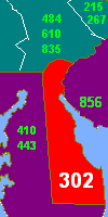
| DescriptionArea code 302.png | Area code map for Delaware in red. | |||
| Date | 28 February 2006 (original upload date) | |||
| Source | Transferred from en.wikipedia to Commons. | |||
| Author | The original uploader was Rfc1394 at English Wikipedia. | |||
| Permission (Reusing this file) |
|

|
This locator map image could be re-created using vector graphics as an SVG file. This has several advantages; see Commons:Media for cleanup for more information. If an SVG form of this image is available, please upload it and afterwards replace this template with
{{vector version available|new image name}}.
It is recommended to name the SVG file “Area code 302.svg”—then the template Vector version available (or Vva) does not need the new image name parameter. |
| This image relies on colours to convey information. However, the colours used make it difficult or even impossible for people with colour blindness to read the information. Please consider changing the colours to meet the needs of a wider audience.
English ∙ British English ∙ Español ∙ français ∙ македонски ∙ português do Brasil ∙ русский ∙ українська ∙ 中文(简体) ∙ 中文(繁體 ∙ +/− |
Original upload log
The original description page was here. All following user names refer to en.wikipedia.
- 2006-02-28 21:48 Rfc1394 100×200×8 (3487 bytes) Area code map for Delaware in red. {{Pd-user|Rfc1394}}
| This file was uploaded with e-mail permission before the introduction of OTRS (now VRT) in 2006; it is a grandfathered old file. |
Captions
Add a one-line explanation of what this file represents
Items portrayed in this file
depicts
image/png
8f5153d564e332bce85e2a2a1531100d92e5a719
3,487 byte
200 pixel
100 pixel
File history
Click on a date/time to view the file as it appeared at that time.
| Date/Time | Thumbnail | Dimensions | User | Comment | |
|---|---|---|---|---|---|
| current | 05:23, 5 August 2007 | | 100 × 200 (3 KB) | Fran Rogers | {{Information |Description=Area code map for Delaware in red. |Source=Originally from [http://en.wikipedia.org en.wikipedia]; description page is/was [http://en.wikipedia.org/w/index.php?title=Image%3AArea_code_302.png here]. |Date=2006-02-28 (original up |
File usage
The following pages on the English Wikipedia use this file (pages on other projects are not listed):
Global file usage
The following other wikis use this file:
- Usage on es.wikipedia.org
Retrieved from "https://en.wikipedia.org/wiki/File:Area_code_302.png"