File:Anwoth_Old_Kirk_and_Kirkyard_-_geograph.org.uk_-_890377.jpg
From Wikipedia, the free encyclopedia
No higher resolution available.
Anwoth_Old_Kirk_and_Kirkyard_-_geograph.org.uk_-_890377.jpg (640 × 480 pixels, file size: 87 KB, MIME type: image/jpeg)
| This is a file from the Wikimedia Commons. Information from its description page there is shown below. Commons is a freely licensed media file repository. You can help. |
Summary
| DescriptionAnwoth Old Kirk and Kirkyard - geograph.org.uk - 890377.jpg |
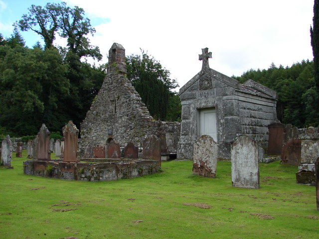
English: Anwoth Old Kirk & Kirkyard The old kirk ruins (1626) retains a medieval bell and has a Samuel Rutherford plaque over the doorway. Interesting gravestones include table stones and a cross-slab. The 2.4m/7.9ft-high granite Gordon mausoleum was built 1878. |
| Date | |
| Source | From geograph.org.uk |
| Author | Chris Newman |
| Attribution (required by the license) InfoField | Chris Newman / Anwoth Old Kirk & Kirkyard / |
InfoField | Chris Newman / Anwoth Old Kirk & Kirkyard |
| Camera location | 54° 52′ 49″ N, 4° 12′ 40″ W | View this and other nearby images on: OpenStreetMap |
|---|
| Object location | 54° 52′ 50″ N, 4° 12′ 38″ W | View this and other nearby images on: OpenStreetMap |
|---|
Licensing

|
This image was taken from the Geograph project collection. See this photograph's page on the Geograph website for the photographer's contact details. The copyright on this image is owned by Chris Newman and is licensed for reuse under the Creative Commons Attribution-ShareAlike 2.0 license.
|
This file is licensed under the Creative Commons Attribution-Share Alike 2.0 Generic license.
Attribution: Chris Newman
- You are free:
- to share – to copy, distribute and transmit the work
- to remix – to adapt the work
- Under the following conditions:
- attribution – You must give appropriate credit, provide a link to the license, and indicate if changes were made. You may do so in any reasonable manner, but not in any way that suggests the licensor endorses you or your use.
- share alike – If you remix, transform, or build upon the material, you must distribute your contributions under the same or compatible license as the original.
Captions
Add a one-line explanation of what this file represents
Items portrayed in this file
depicts
some value
20 July 2008
54°52'48.94"N, 4°12'39.96"W
54°52'49.94"N, 4°12'38.16"W
image/jpeg
ff5bf2bdb3dcdce06525f1b14f6b4d81c0ba506f
89,541 byte
480 pixel
640 pixel
File history
Click on a date/time to view the file as it appeared at that time.
| Date/Time | Thumbnail | Dimensions | User | Comment | |
|---|---|---|---|---|---|
| current | 15:14, 21 February 2011 | | 640 × 480 (87 KB) | GeographBot | == {{int:filedesc}} == {{Information |description={{en|1=Anwoth Old Kirk & Kirkyard The old kirk ruins (1626) retains a medieval bell and has a Samuel Rutherford plague over the doorway. Interesting gravestones include table stones and a cross-slab. The 2 |
File usage
The following pages on the English Wikipedia use this file (pages on other projects are not listed):
Global file usage
The following other wikis use this file:
- Usage on de.wikipedia.org
- Usage on eu.wikipedia.org
- Usage on gd.wikipedia.org
- Usage on vi.wikipedia.org
- Usage on www.wikidata.org
Metadata
This file contains additional information, probably added from the digital camera or scanner used to create or digitize it.
If the file has been modified from its original state, some details may not fully reflect the modified file.
| _error | 0 |
|---|