File:2010PichilemuShakeMapUSGS.png
From Wikipedia, the free encyclopedia
Size of this preview: 479 × 599 pixels. Other resolutions: 192 × 240 pixels | 384 × 480 pixels | 614 × 768 pixels | 1,200 × 1,501 pixels.
Original file (1,200 × 1,501 pixels, file size: 1,013 KB, MIME type: image/png)
| This is a file from the Wikimedia Commons. Information from its description page there is shown below. Commons is a freely licensed media file repository. You can help. |
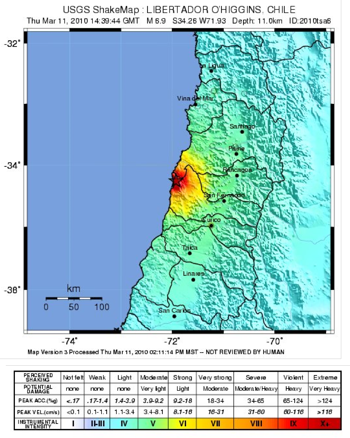
Summary
| Description2010PichilemuShakeMapUSGS.png |
English: Map showing the intensity of shaking from the 2010 Pichilemu earthquake, produced by the USGS |
| Date | |
| Source | USGS [1] |
| Author | USGS |
Licensing
| Public domainPublic domainfalsefalse |
This image is in the public domain in the United States because it only contains materials that originally came from the United States Geological Survey, an agency of the United States Department of the Interior. For more information, see the official USGS copyright policy.
Bahasa Indonesia ∙ català ∙ čeština ∙ Deutsch ∙ eesti ∙ English ∙ español ∙ français ∙ galego ∙ italiano ∙ Nederlands ∙ português ∙ polski ∙ sicilianu ∙ suomi ∙ Tiếng Việt ∙ Türkçe ∙ български ∙ македонски ∙ русский ∙ മലയാളം ∙ 한국어 ∙ 日本語 ∙ 中文 ∙ 中文(简体) ∙ 中文(繁體) ∙ العربية ∙ فارسی ∙ +/− |
Captions
Add a one-line explanation of what this file represents
Items portrayed in this file
depicts
11 March 2010
image/png
cc8d4f26dad3ed1c4f041603b1992e1f8da45a11
1,037,304 byte
1,501 pixel
1,200 pixel
File history
Click on a date/time to view the file as it appeared at that time.
| Date/Time | Thumbnail | Dimensions | User | Comment | |
|---|---|---|---|---|---|
| current | 21:01, 20 January 2011 | | 1,200 × 1,501 (1,013 KB) | Mikenorton | {{Information |Description={{en|1=Map showing the intensity of shaking from the 2010 Pichilemu earthquake, produced by the USGS}} |Source=USGS [http://earthquake.usgs.gov/earthquakes/shakemap/global/shake/2010tsa6/] |Author=USGS |Date=2010-03-11 |Permissi |
File usage
The following pages on the English Wikipedia use this file (pages on other projects are not listed):
Global file usage
The following other wikis use this file:
- Usage on es.wikipedia.org
- Usage on ja.wikipedia.org
- Usage on sco.wikipedia.org
- Usage on simple.wikipedia.org
- Usage on th.wikipedia.org
Metadata
This file contains additional information, probably added from the digital camera or scanner used to create or digitize it.
If the file has been modified from its original state, some details may not fully reflect the modified file.
| Horizontal resolution | 78.74 dpc |
|---|---|
| Vertical resolution | 78.74 dpc |
| Software used |
Retrieved from "https://en.wikipedia.org/wiki/File:2010PichilemuShakeMapUSGS.png"