File:Plymouth_buildings_-4-_(geograph_7633033).jpg
From Wikipedia, the free encyclopedia
Size of this preview: 450 × 600 pixels. Other resolutions: 180 × 240 pixels | 360 × 480 pixels | 576 × 768 pixels | 768 × 1,024 pixels | 1,536 × 2,048 pixels | 3,174 × 4,232 pixels.
Original file (3,174 × 4,232 pixels, file size: 2.22 MB, MIME type: image/jpeg)
| This is a file from the Wikimedia Commons. Information from its description page there is shown below. Commons is a freely licensed media file repository. You can help. |
Summary
| DescriptionPlymouth buildings -4- (geograph 7633033).jpg |
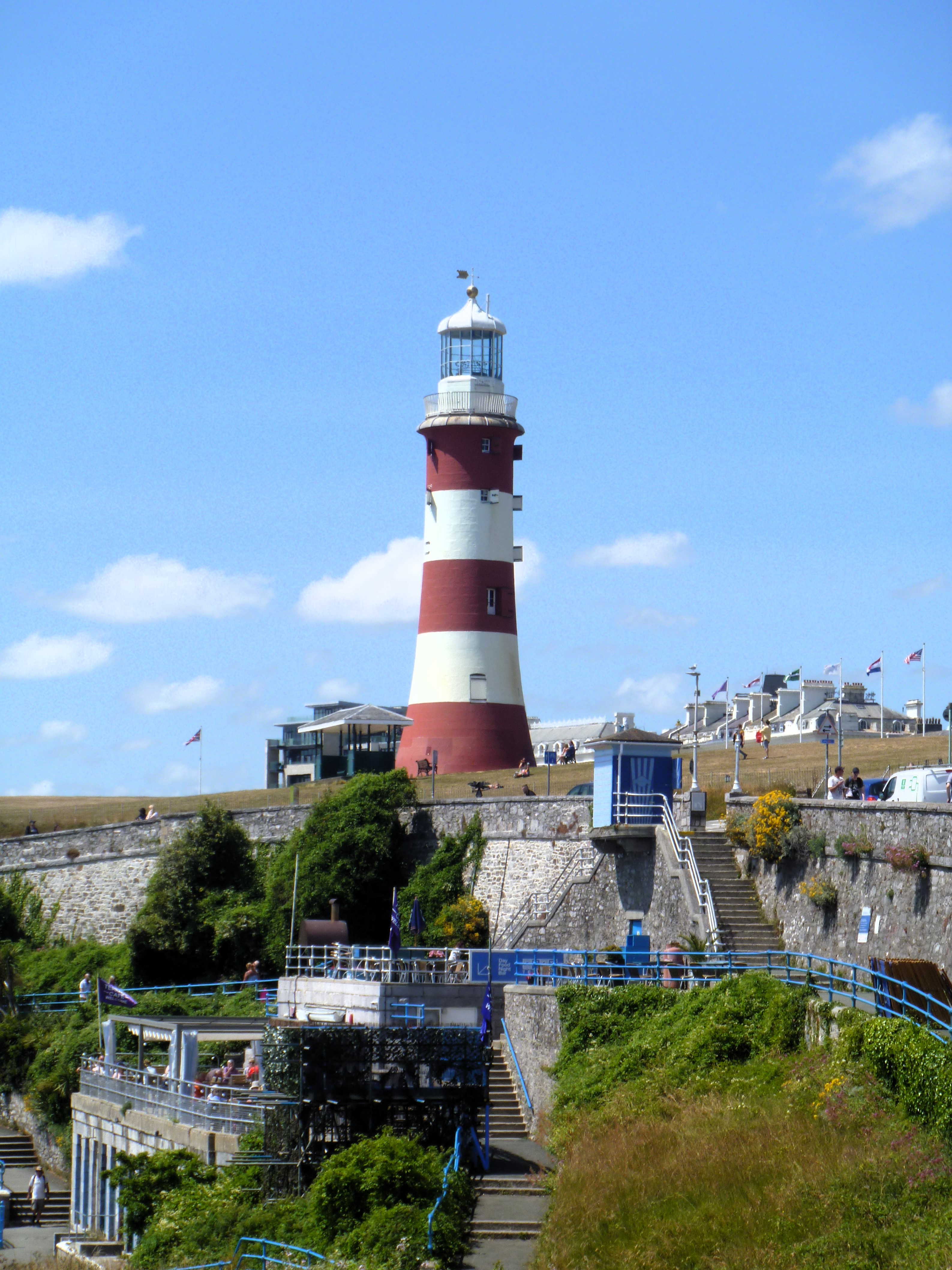
English: Smeaton's Tower on The Hoe is the upper part of the former Eddystone Lighthouse, built in 1759 by John Smeaton, erected here on a new base in 1882. It comprises a circular tapered tower of painted granite ashlar. The tower is listed, grade I, with details at: LinkExternal link. The Hoe is on the Register of Historic Parks and Gardens, grade II.
Plymouth is a port city on the south coast of Devon, some 36 miles (58 km) southwest of Exeter. Settlement in the area dates back into the Bronze Age and it was a Roman trading post. The city became an important shipping port, handling imports and passengers from the Americas, and exporting local minerals. A Royal Navy dockyard was constructed in 1690 at nearby Devonport, now incorporated into Plymouth, which, today, is the largest operational naval base in Western Europe. During World War II, this important naval presence led to the German military targeting and partially destroying the city by bombing. |
| Date | |
| Source | From geograph.org.uk |
| Author | Michael Dibb |
| Permission (Reusing this file) |
Creative Commons Attribution Share-alike license 2.0 |
| Attribution (required by the license) InfoField | Michael Dibb / Plymouth buildings [4] / |
InfoField | Michael Dibb / Plymouth buildings [4] |
| Camera location | 50° 21′ 48.6″ N, 4° 08′ 20″ W | View this and other nearby images on: OpenStreetMap |
|---|
| Object location | 50° 21′ 51.66″ N, 4° 08′ 30.6″ W | View this and other nearby images on: OpenStreetMap |
|---|
Licensing

|
This image was taken from the Geograph project collection. See this photograph's page on the Geograph website for the photographer's contact details. The copyright on this image is owned by Michael Dibb and is licensed for reuse under the Creative Commons Attribution-ShareAlike 2.0 license.
|
This file is licensed under the Creative Commons Attribution-Share Alike 2.0 Generic license.
Attribution: Michael Dibb
- You are free:
- to share – to copy, distribute and transmit the work
- to remix – to adapt the work
- Under the following conditions:
- attribution – You must give appropriate credit, provide a link to the license, and indicate if changes were made. You may do so in any reasonable manner, but not in any way that suggests the licensor endorses you or your use.
- share alike – If you remix, transform, or build upon the material, you must distribute your contributions under the same or compatible license as the original.
Captions
Add a one-line explanation of what this file represents
Items portrayed in this file
depicts
29 June 2023
50°21'48.650"N, 4°8'20.472"W
image/jpeg
af58f6cca89bf848411373f770eac7d864c4aa27
2,332,696 byte
4,232 pixel
3,174 pixel
50°21'51.660"N, 4°8'30.624"W
File history
Click on a date/time to view the file as it appeared at that time.
| Date/Time | Thumbnail | Dimensions | User | Comment | |
|---|---|---|---|---|---|
| current | 21:27, 23 April 2024 | | 3,174 × 4,232 (2.22 MB) | Chocolateediter | == {{int:filedesc}} == {{Information |Description={{en|1=Smeaton's Tower on The Hoe is the upper part of the former Eddystone Lighthouse, built in 1759 by John Smeaton, erected here on a new base in 1882. It comprises a circular tapered tower of painted granite ashlar. The tower is listed, grade I, with details at: LinkExternal link. The Hoe is on the Register of Historic Parks and Gardens, grade II. Plymouth is a port city on the south coast of Devon, some 36 miles (58 km) southwest of Exete... |
File usage
The following pages on the English Wikipedia use this file (pages on other projects are not listed):
Global file usage
The following other wikis use this file:
- Usage on fa.wikipedia.org
- Usage on lv.wikipedia.org
Metadata
This file contains additional information, probably added from the digital camera or scanner used to create or digitize it.
If the file has been modified from its original state, some details may not fully reflect the modified file.
| Camera manufacturer | Panasonic |
|---|---|
| Camera model | DMC-FT10 |
| ISO speed rating | 80 |
| Date and time of data generation | 13:50, 29 June 2023 |
| Exposure Program | Landscape mode (for landscape photos with the background in focus) |
| Date and time of digitizing | 13:50, 29 June 2023 |
| Metering mode | Pattern |
| Light source | Unknown |
| Flash | Flash did not fire, compulsory flash suppression |
| DateTimeOriginal subseconds | 00 |
| DateTimeDigitized subseconds | 00 |
| White balance | Auto white balance |
| Focal length in 35 mm film | 101 mm |
.jpg)