File:1862_Johnson_Map_of_Minnesota_and_Dakota_-_Geographicus_-_MNDK-johnson-1862.jpg
From Wikipedia, the free encyclopedia
Size of this preview: 750 × 600 pixels. Other resolutions: 300 × 240 pixels | 600 × 480 pixels | 961 × 768 pixels | 1,280 × 1,024 pixels | 2,560 × 2,047 pixels | 3,000 × 2,399 pixels.
Original file (3,000 × 2,399 pixels, file size: 1.96 MB, MIME type: image/jpeg)
| This is a file from the Wikimedia Commons. Information from its description page there is shown below. Commons is a freely licensed media file repository. You can help. |
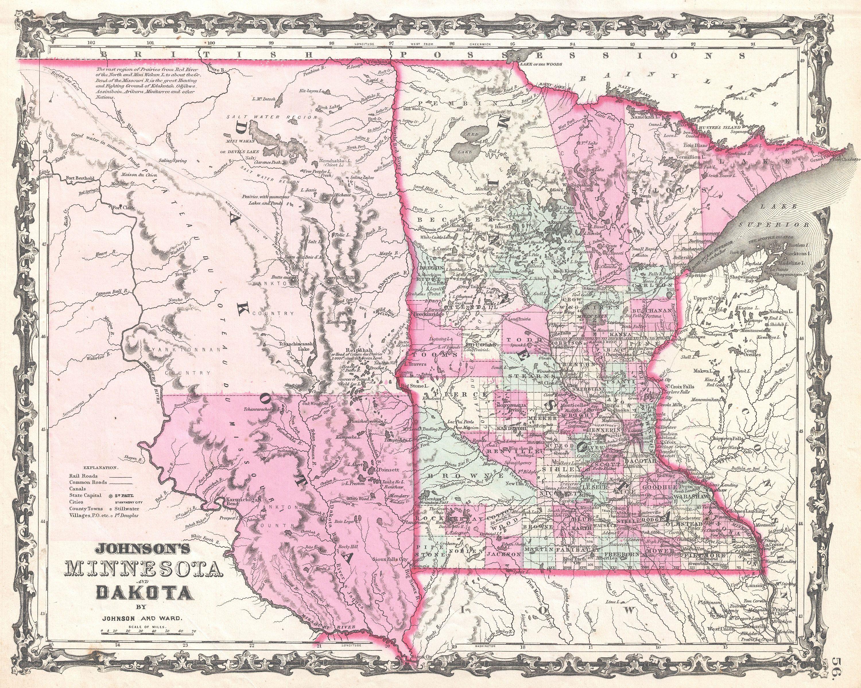
| Alvin Jewett Johnson: Johnson's Minnesota and Dakota.
( |
|||||||||||||||||||||||
|---|---|---|---|---|---|---|---|---|---|---|---|---|---|---|---|---|---|---|---|---|---|---|---|
| Artist |
artist QS:P170,Q18507750 |
||||||||||||||||||||||
| Title |
Johnson's Minnesota and Dakota. |
||||||||||||||||||||||
| Description |
English: A beautiful example of A. J. Johnson’s 1862 map of Minnesota and Dakota. Covers both states as well as adjacent parts of Wisconsin and Iowa. This map predates the splitting of the Dakotas and instead depicts them as a single great state bounded on the west by the Missouri River. The proposed northern route for the Pacific Railroad runs diagonally in a northwesterly direction across both Minnesota and Dakota. Offers color coding according to county and has notations for railways, forts, roadways, cities, towns, and river systems Also notes several American Indian nations including the Kdakotah, Odjibwe, Assiniboin, Aikara, Minitarree and others. Features the strapwork style border common to Johnson’s atlas work from 1860 to 1863. Published by A. J. Johnson and Ward as plate number 56 in the 1862 edition of Johnson’s New Illustrated Family Atlas . This is the first edition of the Family Atlas to bear the Johnson and Ward imprint. |
||||||||||||||||||||||
| Date | 1862 (undated) | ||||||||||||||||||||||
| Dimensions |
height: 12.5 in (31.7 cm); width: 16 in (40.6 cm) dimensions QS:P2048,12.5U218593 dimensions QS:P2049,16U218593 |
||||||||||||||||||||||
| Accession number |
Geographicus link: MNDK-johnson-1862 |
||||||||||||||||||||||
| Source/Photographer |
Johnson, A. J., Johnson's New Illustrated (Steel Plate) Family Atlas with Descriptions, Geographical, Statistical, and Historical. (1862 A. J. Johnson & Ward edition)
|
||||||||||||||||||||||
| Permission (Reusing this file) |
|
||||||||||||||||||||||
Captions
Add a one-line explanation of what this file represents
Items portrayed in this file
depicts
image/jpeg
17411231133217f0db7320670e8ad81d491bbfdb
2,059,189 byte
2,399 pixel
3,000 pixel
File history
Click on a date/time to view the file as it appeared at that time.
| Date/Time | Thumbnail | Dimensions | User | Comment | |
|---|---|---|---|---|---|
| current | 23:52, 22 March 2011 | | 3,000 × 2,399 (1.96 MB) | BotMultichillT | {{subst:User:Multichill/Geographicus |link=http://www.geographicus.com/P/AntiqueMap/MNDK-johnson-1862 |product_name=1862 Johnson Map of Minnesota and Dakota |map_title=Johnson's Minnesota and Dakota. |description=A beautiful example of A. J. Johnson’s 1 |
File usage
The following pages on the English Wikipedia use this file (pages on other projects are not listed):