File:St_Moritz_Muottas.jpg
維基百科,自由的 encyclopedia
原始文件 (1,920 × 1,280像素,文件大小:871 KB,MIME类型:image/jpeg)
摘要
| 描述St Moritz Muottas.jpg |
Беларуская (тарашкевіца): Від на Сьв. Морыц і возера з Муотас да Шлярыгна, Грысонз. Швайцарыя.
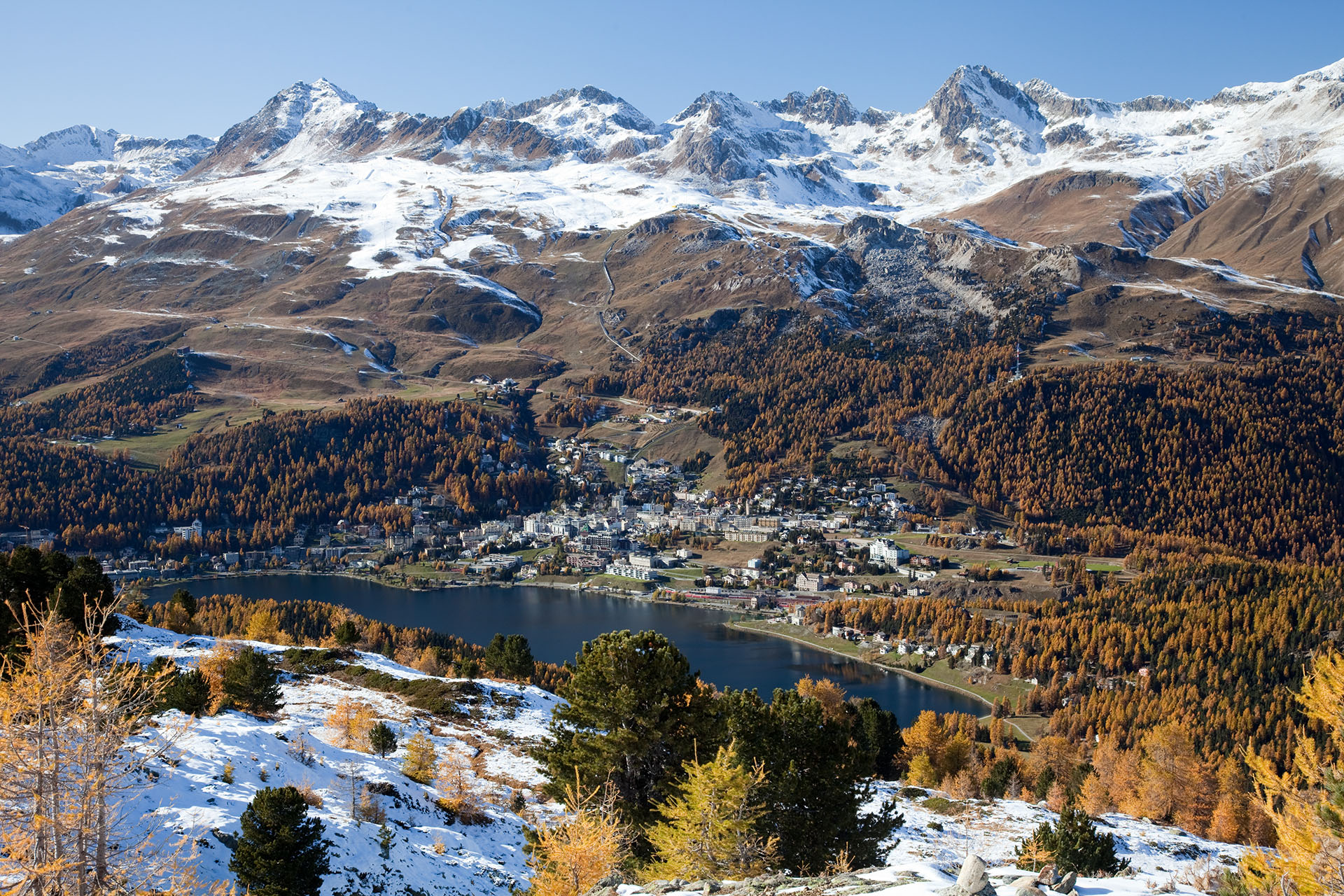
Deutsch: Blick auf St. Moritz, St. Moritzersee und Skigebiet Corviglia im Herbst von Muottas da Schlarigna – links Piz Nair (3056 m), Piz Grisch (3098 m) und Piz Corviglia (3060 m) in der Bildmitte, rechts der Piz Saluver (3159 m) und die Ausläufer des Piz Ot (3246 m) am Bildrand
English: View of St. Moritz and its lake, as seen from Muottas da Schlarigna, Grisons. Switzerland. On the left is Piz Nair (3056 m), to the right is Piz Saluver (3159 m)
Español: Vista de San Moritz y su lago. Tomado desde Muottas de Schlarigna, Grisones, Suiza.
Français : Vue sur Saint-Moritz et son lac, prise depuis Muottas da Schlarigna. Canton des Grisons (Suisse).
Rumantsch: Vista da Muottas da Schlarigna sin San Murezzan, il Lai da San Murezzan ed il territori da skis Corviglia. |
| 日期 | 2010年10月21日 (根据EXIF的数据) |
| 来源 | 自己的作品 |
| 作者 | Murdockcrc |
| 相机位置 | 46° 28′ 58.8″ 北, 9° 52′ 45.6″ 东 | 在以下服务上查看本图像和附近其他图像: OpenStreetMap |
|---|
|

English: View of St. Moritz and the lake, as seen from Muottas da Schlarigna, Grisons. Switzerland. 其他语言:
Deutsch: Aufnahme von St. Moritz mit St. Moritzersee, vom Muottas Muragl aus gesehen (Kanton Graubünden in der Schweiz) English: View of St. Moritz and the lake, as seen from Muottas da Schlarigna, Grisons. Switzerland. Español: Vista de Sankt Moritz y el lago desde Muottas da Schlarigna (Cantón de los Grisones, Suiza). Français : Saint-Moritz et son lac, vus de Muottas da Schlarigna, Grisons. Suisse. Nederlands: Panorama van St. Moritz en het Meer van Sankt Moritz, gezien vanaf Muottas da Schlarigna, Graubünden, Zwitserland. 中文: 瑞士圣莫里茨风景 |
|
العربية ∙ جازايرية ∙ беларуская ∙ беларуская (тарашкевіца) ∙ български ∙ বাংলা ∙ català ∙ čeština ∙ Cymraeg ∙ Deutsch ∙ Schweizer Hochdeutsch ∙ Zazaki ∙ Ελληνικά ∙ English ∙ Esperanto ∙ español ∙ eesti ∙ euskara ∙ فارسی ∙ suomi ∙ français ∙ galego ∙ עברית ∙ हिन्दी ∙ hrvatski ∙ magyar ∙ հայերեն ∙ Bahasa Indonesia ∙ italiano ∙ 日本語 ∙ Jawa ∙ ქართული ∙ 한국어 ∙ kurdî ∙ Lëtzebuergesch ∙ lietuvių ∙ македонски ∙ മലയാളം ∙ मराठी ∙ Bahasa Melayu ∙ Nederlands ∙ Norfuk / Pitkern ∙ polski ∙ português ∙ português do Brasil ∙ rumantsch ∙ română ∙ русский ∙ sicilianu ∙ slovenčina ∙ slovenščina ∙ shqip ∙ српски / srpski ∙ svenska ∙ தமிழ் ∙ తెలుగు ∙ ไทย ∙ Tagalog ∙ Türkçe ∙ toki pona ∙ українська ∙ vèneto ∙ Tiếng Việt ∙ 中文 ∙ 中文(简体) ∙ 中文(繁體) ∙ +/− |
许可协议

|
已授权您依据自由软件基金会发行的无固定段落及封面封底文字(Invariant Sections, Front-Cover Texts, and Back-Cover Texts)的GNU自由文件许可协议1.2版或任意后续版本的条款,复制、传播和/或修改本文件。该协议的副本请见“GNU Free Documentation License”。http://www.gnu.org/copyleft/fdl.htmlGFDLGNU Free Documentation Licensetruetrue |
- 您可以自由地:
- 共享 – 复制、发行并传播本作品
- 修改 – 改编作品
- 惟须遵守下列条件:
- 署名 – 您必须对作品进行署名,提供授权条款的链接,并说明是否对原始内容进行了更改。您可以用任何合理的方式来署名,但不得以任何方式表明许可人认可您或您的使用。
| 註解 InfoField | 該圖片含有註解:在維基媒體共享資源上查看註解 |
Piz Nair (3056 m)
Lake of St. Moritz (1768 m)
St. Moritz Train Station
Signalbahn (2130 m)
Piz Saluver (3161 m)
Sass da Muottas (2364 m)
Corviglia (2486 m)
Chantarella (2005 m)
Salastrains
Piz Grisch (3098 m)
Corn Suvretta (3072 m)
Piz Surgonda (3197 m)
Piz Bever (3230 m)
Munt da San Murezzan
Statzerwald
Piz Glüna (3102 m)
Piz Corviglia (3060 m)
Piz Grisch (3098 m)
Ils Chejels (2969 m)
Alp Giop
说明
此文件中描述的项目
描繪內容
某些值没有维基数据项目
GNU自由文档许可证1.2或更高版本 简体中文(已转写)
共享资源质量评价 简体中文(已转写)
摄影器材 简体中文(已转写)
21 10 2010
46°28'58.800"N, 9°52'45.599"E
曝光时间 简体中文(已转写)
0.03333333333333333333 秒
11
焦距 简体中文(已转写)
50 毫米
160
image/jpeg
文件历史
点击某个日期/时间查看对应时刻的文件。
| 日期/时间 | 缩略图 | 大小 | 用户 | 备注 | |
|---|---|---|---|---|---|
| 当前 | 2010年11月29日 (一) 10:09 | | 1,920 × 1,280(871 KB) | Murdockcrc | {{Information |Description={{en|1=View of St. Moritz and the lake, as seen from Muottas da Schlarigna, Grisons. Switzerland.}} {{es|1=Vista de San Moritz y su lago. Tomado desde Muottas de Schlarigna, Grisones, Suiza.}} |Source={{own}} |Author=[[User:Murd |
文件用途
全域文件用途
以下其他wiki使用此文件:
- ar.wikipedia.org上的用途
- arz.wikipedia.org上的用途
- be-tarask.wikipedia.org上的用途
- bn.wikipedia.org上的用途
- ceb.wikipedia.org上的用途
- crh.wikipedia.org上的用途
- cs.wikipedia.org上的用途
- cv.wikipedia.org上的用途
- da.wikipedia.org上的用途
- de.wikipedia.org上的用途
- en.wikipedia.org上的用途
- St. Moritz
- Talk:St. Moritz
- Wikipedia:Featured pictures/Places/Landscapes
- Wikipedia:Featured pictures thumbs/26
- Wikipedia:Featured picture candidates/December-2010
- Wikipedia:Featured picture candidates/St. Moritz - Muottas da Schlarigna
- User talk:Murdockcrc
- List of Olympic venues in cross-country skiing
- Wikipedia:Picture of the day/July 2012
- Template:POTD/2012-07-28
- Wikipedia:Main Page history/2012 July 28
- Piz Saluver
- User:Mandip Si
- es.wikipedia.org上的用途
- es.wikivoyage.org上的用途
- fa.wikipedia.org上的用途
- fi.wikipedia.org上的用途
- fr.wikipedia.org上的用途
- he.wikipedia.org上的用途
查看本文件的更多全域用途。
元数据
此文件中包含有扩展的信息。这些信息可能是由数码相机或扫描仪在创建或数字化过程中所添加。
如果此文件的源文件已经被修改,一些信息在修改后的文件中将不能完全反映出来。
| 图像标题 | St. Moritz and the lake. On the background: Piz Nair (3056m), Piz Corviglia (3060m), Piz Saluver. |
|---|---|
| 相机制造商 | Canon |
| 相机型号 | Canon EOS 5D Mark II |
| 曝光时间 | 1/30秒(0.033333333333333) |
| 光圈值 | f/11 |
| 感光度(ISO) | 160 |
| 数据生成日期时间 | 2010年10月21日 (四) 15:31 |
| 焦距 | 50 mm |
| 像素构成 | RGB |
| 方位 | 标准 |
| 水平分辨率 | 72 dpi |
| 垂直分辨率 | 72 dpi |
| 使用软件 | Adobe Photoshop CS4 Macintosh |
| 文件修改日期时间 | 2010年11月29日 (一) 11:02 |
| 曝光程序 | 光圈优先模式 |
| Exif版本 | 2.21 |
| 数字化日期时间 | 2010年10月21日 (四) 15:31 |
| APEX快门速度 | 4.9068908941756 |
| APEX光圈 | 6.9188626907074 |
| 曝光补偿 | 0 |
| 最大陆地光圈 | 4 APEX (f/4) |
| 测光模式 | 模式 |
| 闪光灯 | 闪光灯未点亮、闪光灯强制关闭 |
| 修改时间厘秒数 | 81 |
| 数据生成时间厘秒数 | 81 |
| 数字化时间厘秒数 | 81 |
| 色彩空间 | sRGB |
| 焦平面X分辨率 | 3,849.2115384615 |
| 焦平面Y分辨率 | 3,908.1418439716 |
| 焦平面分辨率单位 | 英寸 |
| 图像处理 | 标准处理 |
| 曝光模式 | 自动曝光 |
| 白平衡 | 自动白平衡 |
| 场景模式 | 标准 |
| 对比度 | 39 |
| 饱和度 | 标准 |
| 锐化 | 25 |
| 北纬或南纬 | 北纬 |
| 东经或西经 | 东经 |