File:Map_of_African_language_families.svg
維基百科,自由的 encyclopedia

此SVG文件的PNG预览的大小:635 × 600像素。 其他分辨率:254 × 240像素 | 508 × 480像素 | 813 × 768像素 | 1,084 × 1,024像素 | 2,169 × 2,048像素 | 1,525 × 1,440像素。
原始文件 (SVG文件,尺寸为1,525 × 1,440像素,文件大小:1.05 MB)
摘要
| 描述Map of African language families.svg |
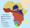
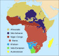
English: Map of the major African language families. Click on any language family in the image to view its respective Wikipedia article.
Bahasa Indonesia: Peta yang menampilkan rumpun bahasa utama di Afrika. Klik nama untuk setiap rumpun bahasa di gambar tersebut untuk melihat artikel yang terkait di Wikipedia.
Legend: |
| 日期 | |
| 来源 |
|
| 作者 | User:SUM1 |
| 其他版本 |
[编辑]
|
许可协议
我,本作品著作权人,特此采用以下许可协议发表本作品:
本文件采用知识共享署名-相同方式共享 4.0 国际许可协议授权。
- 您可以自由地:
- 共享 – 复制、发行并传播本作品
- 修改 – 改编作品
- 惟须遵守下列条件:
- 署名 – 您必须对作品进行署名,提供授权条款的链接,并说明是否对原始内容进行了更改。您可以用任何合理的方式来署名,但不得以任何方式表明许可人认可您或您的使用。
- 相同方式共享 – 如果您再混合、转换或者基于本作品进行创作,您必须以与原先许可协议相同或相兼容的许可协议分发您贡献的作品。
说明
添加一行文字以描述该文件所表现的内容
Map of the major language families of Africa
Mapa de les famílies primàries de llengües africanes
Karta över de största språkfamiljerna i Afrika
此文件中描述的项目
描繪內容
22 6 2017
文件历史
点击某个日期/时间查看对应时刻的文件。
| 日期/时间 | 缩略图 | 大小 | 用户 | 备注 | |
|---|---|---|---|---|---|
| 当前 | 2023年10月2日 (一) 20:52 | | 1,525 × 1,440(1.05 MB) | Xavier Dengra | File uploaded using svgtranslate tool (https://svgtranslate.toolforge.org/). Added translation for ca. |
| 2023年6月20日 (二) 02:11 |  | 1,525 × 1,440(1.04 MB) | Illchy | File uploaded using svgtranslate tool (https://svgtranslate.toolforge.org/). Added translation for id. | |
| 2017年7月15日 (六) 23:57 |  | 1,525 × 1,440(1.1 MB) | SUM1 | Fixed drop shadows glitch | |
| 2017年7月15日 (六) 23:43 |  | 1,525 × 1,440(1.13 MB) | SUM1 | Fixed Niger–Congo boundary | |
| 2017年7月12日 (三) 20:27 |  | 1,525 × 1,440(1.09 MB) | SUM1 | Fixed Kordofanian boundaries and overlaps | |
| 2017年7月6日 (四) 00:09 |  | 1,525 × 1,440(1.08 MB) | SUM1 | Shifted key closer to continent | |
| 2017年7月5日 (三) 17:14 |  | 1,525 × 1,440(1.08 MB) | SUM1 | Enlarged key | |
| 2017年6月28日 (三) 10:21 |  | 1,525 × 1,440(1.08 MB) | SUM1 | Closed gaps in continent, fixed overlaps, fixed rogue colours and removed excess nodes | |
| 2017年6月25日 (日) 01:38 |  | 1,525 × 1,440(1.16 MB) | SUM1 | Added drop shadows to bullets and islands | |
| 2017年6月22日 (四) 20:28 |  | 1,525 × 1,440(1.11 MB) | SUM1 | Made key circles smaller for readability |
文件用途
以下页面使用本文件:
全域文件用途
以下其他wiki使用此文件:
- cy.wikipedia.org上的用途
- en.wikipedia.org上的用途
- fa.wikipedia.org上的用途
- fi.wikipedia.org上的用途
- hy.wikipedia.org上的用途
- id.wikipedia.org上的用途
- mg.wikipedia.org上的用途
- mk.wikipedia.org上的用途
- ps.wikipedia.org上的用途
- sv.wikipedia.org上的用途
- tum.wikipedia.org上的用途
- uk.wikipedia.org上的用途
- www.wikidata.org上的用途
- zh-yue.wikipedia.org上的用途
元数据
此文件中包含有扩展的信息。这些信息可能是由数码相机或扫描仪在创建或数字化过程中所添加。
如果此文件的源文件已经被修改,一些信息在修改后的文件中将不能完全反映出来。
| 简短标题 | Blank map of the African continent |
|---|---|
| 宽度 | 1524.9999 |
| 高度 | 1439.9999 |