File:Caspian_Sea_from_orbit.jpg
維基百科,自由的 encyclopedia
本预览的尺寸:471 × 599像素。 其他分辨率:188 × 240像素 | 377 × 480像素 | 603 × 768像素 | 804 × 1,024像素 | 1,609 × 2,048像素 | 4,400 × 5,600像素。
原始文件 (4,400 × 5,600像素,文件大小:3.44 MB,MIME类型:image/jpeg)
摘要
| 描述Caspian Sea from orbit.jpg |
العربية: منظرٌ من مدار الأرض لِبحر قزوين. التعليق الأصلي: كما أوردته وكالة الناسا: ::"القسم الشمالي من بحر قزوين يُعاني من ظاهرةٍ تُعرف باسم التخثث أو إغناء الماء، وهي تلك الحالة التي تتسببُ فيها الأسمدة الزراعيَّة المُنسابة من خِلال مياه الري والأمطار بِنُمو الطحالب في المياه. يُؤدي نُفوق وتحلُّل تلك الطحالب إلى حرمان المياه من الأكسجين، ممَّا يُؤدي بِدوره إلى الإضرار بِالحياة البريَّة بِطبيعة الحال. هذه الصُورة لِبحر قزوين تُظهرُ بعض الدوَّامات الخضراء والزرقاء على مقرُبةٍ من مصب نهر الڤولغا (أعلى الوسط)، ممَّا يدُل على وُجود كميَّةٍ من الطحالب. اللون الأزرق اللامع في القسم الشمالي الشرقي من البحر قد يكون تولَّد نتيجة اختلاط بعض النباتات بِالترسُبات، نظرًا لِأنَّ هذا الموقع هو أكثر المناطق ضُحولةً في البحر.
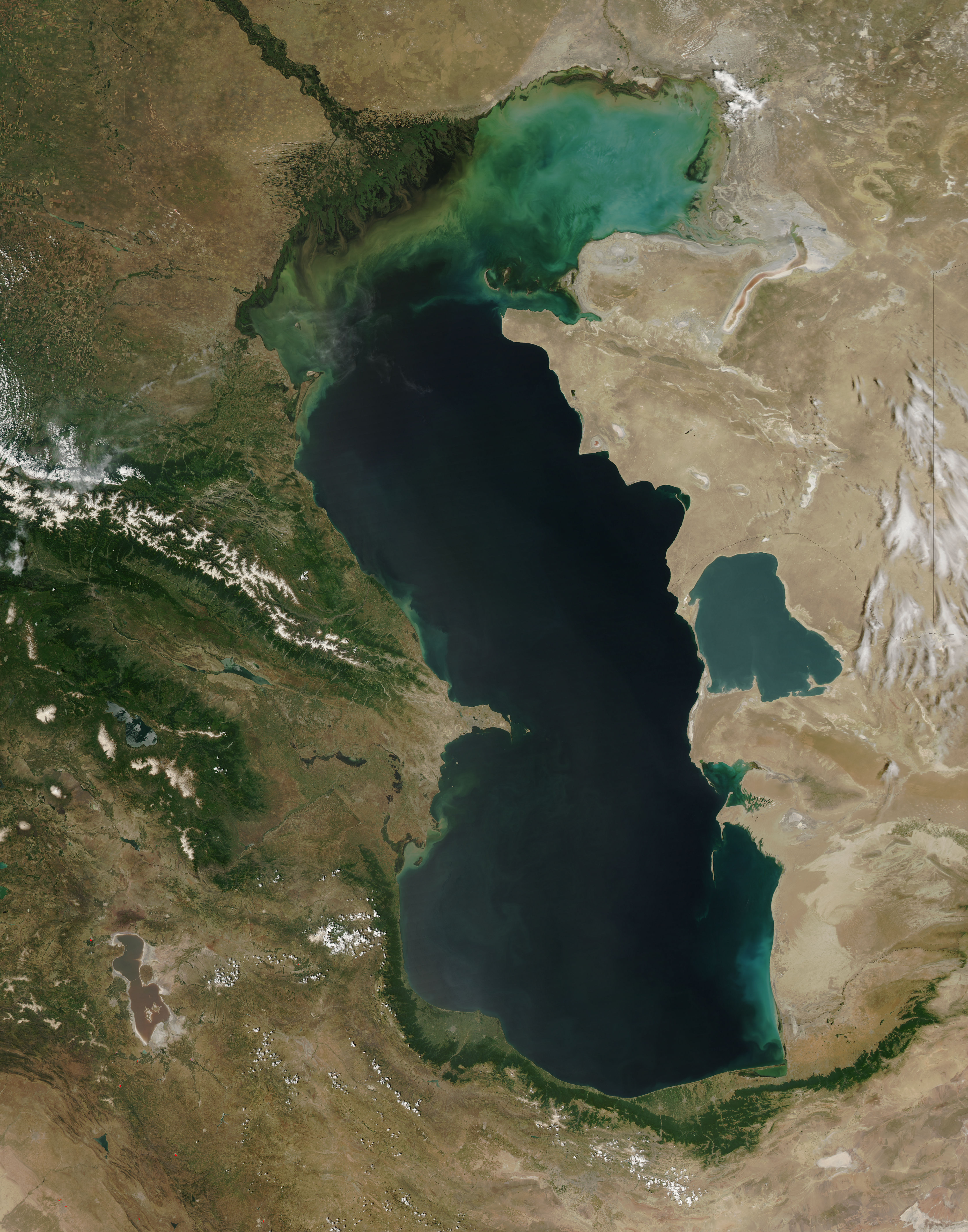
English: This is a view from orbit of the Caspian Sea as imaged by the MODIS sensor on the Terra satellite. Caption: The original caption from NASA: ::"The northern part of the Caspian Sea is plagued by a process called eutrophication, in which agricultural run-off rich in fertilizers stimulates rampant growth of algae in the water. The death and decay of these algae robs the water of oxygen, with obvious negative consequences for aquatic life. This image of the Caspian Sea shows swirls of green and blue near the mouth of the Volga River (top center), which indicate the presence of algae. The bright blue color of the northeastern part of the sea may be due to a mixture of plant life and sediment, for this is where the sea is most shallow. This image is from the Moderate Resolution Imaging Spectroradiometer (MODIS) on the Terra satellite on June 11, 2003.
Español: El Mar Caspio visto desde la órbita terrestre
فارسی: تصویر ماهوارهای از دریای خزر
Тоҷикӣ: Тасвири Баҳр Каспӣ аз осмон |
| 日期 | |
| 来源 |
http://visibleearth.nasa.gov/view_rec.php?id=5514
|
| 作者 | Jeff Schmaltz, MODIS Rapid Response Team, NASA/GSFC |
| 其他版本 | 此文件衍生的作品: Caspian Sea from orbit-NoRedLines.jpg |
|

|
根据最有价值图像标准,这张图像被评定为在Satellite images of the Caspian Sea范畴内最有价值的共享资源图像。你可以在Commons:Valued image candidates/Caspian Sea from orbit.jpg参看它的提名。 |
许可协议
| Public domainPublic domainfalsefalse |
| 本文件完全由NASA创作,在美国属于公有领域。根据NASA的版权方针,NASA的材料除非另有声明否则不受版权保护。(参见Template:PD-USGov/zh、NASA版权方针页面或JPL图片使用方针。) | ||
 |
警告:
|
说明
添加一行文字以描述该文件所表现的内容
Caspian Sea from orbit (here the image from MODIS of the Terra satellite on June 11, 2003)
Mar Cáspio.
Kaspisches Meer in der Satellitenansicht (hier das Bild von MODIS vom Satellit Terra am 11. Juni 2003)
XƏZƏR
تصویر ماهوارهای از دریای خزر
共享资源质量评价 简体中文(已转写)
11 6 2003
image/jpeg
3,608,474 字节
5,600 像素
4,400 像素
文件历史
点击某个日期/时间查看对应时刻的文件。
| 日期/时间 | 缩略图 | 大小 | 用户 | 备注 | |
|---|---|---|---|---|---|
| 当前 | 2010年6月14日 (一) 09:16 | | 4,400 × 5,600(3.44 MB) | Originalwana | higher res |
| 2005年2月8日 (二) 15:10 |  | 550 × 700(67 KB) | Pixeltoo | Caspian sea by space Nasa |
文件用途
以下5个页面使用本文件:
全域文件用途
以下其他wiki使用此文件:
- af.wikipedia.org上的用途
- als.wikipedia.org上的用途
- am.wikipedia.org上的用途
- ang.wikipedia.org上的用途
- an.wikipedia.org上的用途
- arc.wikipedia.org上的用途
- ar.wikipedia.org上的用途
- بحر قزوين
- ويكيبيديا:صور مختارة/الفضاء والكون/نظرة إلى الخلف
- ويكيبيديا:ترشيحات الصور المختارة/بحر قزوين
- ويكيبيديا:صورة اليوم المختارة/ديسمبر 2016
- قالب:صورة اليوم المختارة/2016-12-23
- مستخدم:قائمة أكبر البحيرات والبحار في المجموعة الشمسية
- ويكيبيديا:صورة اليوم المختارة/يوليو 2020
- قالب:صورة اليوم المختارة/2020-07-16
- ويكيبيديا:صورة اليوم المختارة/يوليو 2023
- قالب:صورة اليوم المختارة/2023-07-26
- arz.wikipedia.org上的用途
- ast.wikipedia.org上的用途
- as.wikipedia.org上的用途
- av.wikipedia.org上的用途
- azb.wikipedia.org上的用途
- az.wikipedia.org上的用途
- bat-smg.wikipedia.org上的用途
- be.wikipedia.org上的用途
- bew.wikipedia.org上的用途
- bg.wikipedia.org上的用途
- bh.wikipedia.org上的用途
- bn.wikipedia.org上的用途
- br.wikipedia.org上的用途
- bs.wikipedia.org上的用途
- bxr.wikipedia.org上的用途
- ca.wikipedia.org上的用途
- ce.wikipedia.org上的用途
- ckb.wikipedia.org上的用途
- co.wikipedia.org上的用途
- cs.wikipedia.org上的用途
查看本文件的更多全域用途。
元数据
此文件中包含有扩展的信息。这些信息可能是由数码相机或扫描仪在创建或数字化过程中所添加。
如果此文件的源文件已经被修改,一些信息在修改后的文件中将不能完全反映出来。
| _error | 0 |
|---|