File:Biafra_independent_state_map-en.svg
維基百科,自由的 encyclopedia

此SVG文件的PNG预览的大小:776 × 600像素。 其他分辨率:311 × 240像素 | 621 × 480像素 | 994 × 768像素 | 1,280 × 989像素 | 2,560 × 1,978像素 | 1,100 × 850像素。
原始文件 (SVG文件,尺寸为1,100 × 850像素,文件大小:472 KB)
| 此SVG檔案包含可翻譯至您的語言的内嵌文字,可以使用任何可用SVG編輯器、文本編輯器或SVG翻譯工具來翻譯。詳情請見:關於翻譯SVG檔案。 |
摘要
| 描述Biafra independent state map-en.svg |
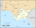
Català: Mapa de la república de Biafra en el maig 1967. English: Map of the secessionist state of the Republic of Biafra (1967 – 1970) as in May 1967. Note: The western boundary may not be accurate due to the low precision of the reference maps used which are also contradictory. Français : Carte en anglais de l'État sécessionniste de la République du Biafra (1967 – 1970) telle qu'en mai 1967. Note : La frontière Ouest peut ne pas être précise en raison de l'imprécision des cartes de référence qui sont aussi contradictoires. UTM projection ; WGS 84 datum |
||
| 日期 | September 2008 (new version) | ||
| 来源 |
Own work
|
||
| 作者 | Eric Gaba (Sting - fr:Sting) | ||
| 授权 (二次使用本文件) |
|
||
| 其他版本 |
[编辑]
|


| 此SVG檔案包含可翻譯至您的語言的内嵌文字,可以使用任何可用SVG編輯器、文本編輯器或SVG翻譯工具來翻譯。詳情請見:關於翻譯SVG檔案。 |
许可协议
我,本作品著作权人,特此采用以下许可协议发表本作品:

|
已授权您依据自由软件基金会发行的无固定段落及封面封底文字(Invariant Sections, Front-Cover Texts, and Back-Cover Texts)的GNU自由文件许可协议1.2版或任意后续版本的条款,复制、传播和/或修改本文件。该协议的副本请见“GNU Free Documentation License”。http://www.gnu.org/copyleft/fdl.htmlGFDLGNU Free Documentation Licensetruetrue |
| 本文件采用知识共享署名-相同方式共享 3.0 未本地化版本许可协议授权。 | ||
| ||
| 本许可协议标签作为GFDL许可协议更新的组成部分被添加至本文件。http://creativecommons.org/licenses/by-sa/3.0/CC BY-SA 3.0Creative Commons Attribution-Share Alike 3.0truetrue |
- 您可以自由地:
- 共享 – 复制、发行并传播本作品
- 修改 – 改编作品
- 惟须遵守下列条件:
- 署名 – 您必须对作品进行署名,提供授权条款的链接,并说明是否对原始内容进行了更改。您可以用任何合理的方式来署名,但不得以任何方式表明许可人认可您或您的使用。
- 相同方式共享 – 如果您再混合、转换或者基于本作品进行创作,您必须以与原先许可协议相同或相兼容的许可协议分发您贡献的作品。
您可以选择您需要的许可协议。
说明
添加一行文字以描述该文件所表现的内容
Map of the secessionist state of the Republic of Biafra (1967–1970) as in May 1967
Mapa de la república de Biafra el maig de 1967
此文件中描述的项目
描繪內容
知识共享署名-相同方式共享2.5通用 简体中文(已转写)
GNU自由文档许可证1.2或更高版本 简体中文(已转写)
知识共享署名-相同方式共享2.0通用 简体中文(已转写)
知识共享署名-相同方式共享1.0通用 简体中文(已转写)
image/svg+xml
483,714 字节
850 像素
1,100 像素
文件历史
点击某个日期/时间查看对应时刻的文件。
| 日期/时间 | 缩略图 | 大小 | 用户 | 备注 | |
|---|---|---|---|---|---|
| 当前 | 2023年9月15日 (五) 19:21 | | 1,100 × 850(472 KB) | Glrx | 256 kB workaround // Editing SVG source code using c:User:Rillke/SVGedit.js |
| 2023年9月15日 (五) 10:59 |  | 1,100 × 850(472 KB) | KajenCAT | File uploaded using svgtranslate tool (https://svgtranslate.toolforge.org/). Added translation for ca. | |
| 2008年9月3日 (三) 04:51 |  | 1,100 × 850(455 KB) | Sting | New version using the NGDC GSHHS and WDBII data ; new standard colors | |
| 2006年12月12日 (二) 17:54 |  | 1,100 × 850(163 KB) | Sting | {{Information| |Description=Map of the secessionist state of the Republic of Biafra (1967 – 1970) |Source=Own work<br/>Background reference map : Microsoft Encarta atlas (1999 edition)<br/>Biafra independent state borders reference maps : [http://www.bi |
文件用途
全域文件用途
以下其他wiki使用此文件:
- af.wikipedia.org上的用途
- ar.wikipedia.org上的用途
- ast.wikipedia.org上的用途
- azb.wikipedia.org上的用途
- be.wikipedia.org上的用途
- bn.wikipedia.org上的用途
- br.wikipedia.org上的用途
- ca.wikipedia.org上的用途
- cs.wikipedia.org上的用途
- da.wikipedia.org上的用途
- el.wikipedia.org上的用途
- en.wikipedia.org上的用途
- eo.wikipedia.org上的用途
- es.wikipedia.org上的用途
- et.wikipedia.org上的用途
- eu.wikipedia.org上的用途
- fa.wikipedia.org上的用途
- fr.wikipedia.org上的用途
- gl.wikipedia.org上的用途
- ha.wikipedia.org上的用途
- he.wikipedia.org上的用途
- hu.wikipedia.org上的用途
- hy.wikipedia.org上的用途
- id.wikipedia.org上的用途
- ig.wikipedia.org上的用途
- io.wikipedia.org上的用途
查看本文件的更多全域用途。
元数据
此文件中包含有扩展的信息。这些信息可能是由数码相机或扫描仪在创建或数字化过程中所添加。
如果此文件的源文件已经被修改,一些信息在修改后的文件中将不能完全反映出来。
| 宽度 | 1100 |
|---|---|
| 高度 | 850 |