Bestand:Mercator_world_map_(physical,_political,_population).jpg
Uit Wikipedia, de vrije encyclopedia
Grootte van deze voorvertoning: 800 × 511 pixels. Andere resoluties: 320 × 204 pixels | 640 × 408 pixels | 1.024 × 654 pixels | 1.280 × 817 pixels | 2.560 × 1.634 pixels | 6.944 × 4.432 pixels.
Oorspronkelijk bestand (6.944 × 4.432 pixels, bestandsgrootte: 7,28 MB, MIME-type: image/jpeg)
| Dit is een bestand van Wikimedia Commons. Onderstaande beschrijving komt van de beschrijving van het bestand daar. |
Beschrijving
| BeschrijvingMercator world map (physical, political, population).jpg |
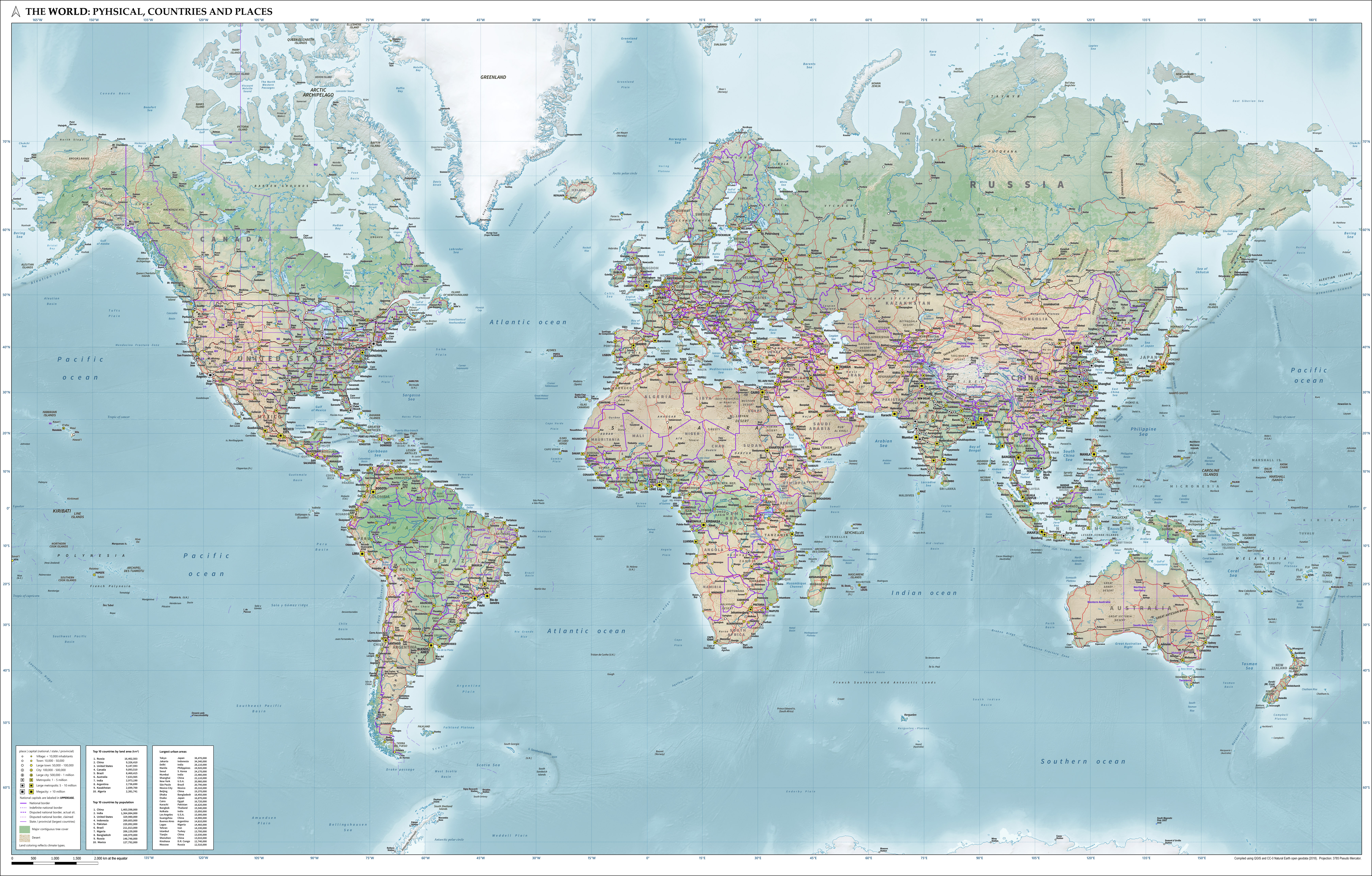
English: Combined map of the world in Pseudo Mercator projection showing physical, political and population characteristics, as per 2018. Compiled using QGIS and CC-0 Natural Earth data. Includes legend of symbols. |
| Datum | |
| Bron | Eigen werk |
| Auteur | Janwillemvanaalst |
Licentie
Ik, de auteursrechthebbende van dit werk, maak het hierbij onder de volgende licentie beschikbaar:
Dit bestand is gelicenseerd onder de Creative Commons Naamsvermelding 4.0 Internationaal licentie.
- De gebruiker mag:
- Delen – het werk kopiëren, verspreiden en doorgeven
- Remixen – afgeleide werken maken
- Onder de volgende voorwaarden:
- naamsvermelding – U moet op een gepaste manier aan naamsvermelding doen, een link naar de licentie geven, en aangeven of er wijzigingen in het werk zijn aangebracht. U mag dit op elke redelijke manier doen, maar niet zodanig dat de indruk wordt gewekt dat de licentiegever instemt met uw werk of uw gebruik van zijn werk.
Bijschriften
Kaart van de wereld met geografische, politieke en bevolkingskarakteristieken per 2018, in Mercator projectie, gebaseerd op CC0 Natural Earth geodata.
Map of the world showing physical, political and population characteristics as per 2018, in Mercator projection, based on CC-0 Natural Earth geodata.
Carte du monde montrant des caractéristiques physiques, politiques et démographiques selon 2018, en projection Mercator, basée sur les données CC-0 Natural Earth
Weltkarte mit physischen, politischen und Bevölkerungsmerkmalen gemäß 2018 in Mercator-Projektion, basierend auf den CC0 Geodaten Natural Earth.
Mapa del mundo con características físicas, políticas y poblacionales según 2018, en proyección Mercator, basado en geodatos CC0 Natural Earth.
Waarde zonder Wikidata-item
15 aug 2020
image/jpeg
Bestandsgeschiedenis
Klik op een datum/tijd om het bestand te zien zoals het destijds was.
| Datum/tijd | Miniatuur | Afmetingen | Gebruiker | Opmerking | |
|---|---|---|---|---|---|
| huidige versie | 4 okt 2020 08:13 | | 6.944 × 4.432 (7,28 MB) | Janwillemvanaalst | Added additional regional labels, a few more places, and renamed the capital of Kazakhstan from Astana to Nur-Sultan. |
| 19 sep 2020 09:03 |  | 6.944 × 4.432 (7,23 MB) | Janwillemvanaalst | Added ocean water region labels and trench depths in m, as well as some extra mountain peaks. | |
| 9 sep 2020 08:00 |  | 6.944 × 4.432 (7,11 MB) | Janwillemvanaalst | Corrected lakes and rivers outline styling; added African regional names; added settlements in Siberia and Canada; adjusted some place labels. | |
| 6 sep 2020 08:43 |  | 6.944 × 4.432 (7,06 MB) | Janwillemvanaalst | Added regional toponyms "Yucatán", "Sahel", "Sudd", "Anatolia", "Caspian Lowland", and included some extra places, in both densely populated and sparsely populated areas. Corrected size symbol for Surabaya (Indonesia) and Changsha (China), who both crossed the 5 million urban inhabitants threshold in 2018. | |
| 2 sep 2020 08:22 |  | 6.944 × 4.432 (7,03 MB) | Janwillemvanaalst | Improved balance of place names across the different parts of the world. | |
| 29 aug 2020 07:49 |  | 6.944 × 4.432 (6,95 MB) | Janwillemvanaalst | Some further label enhancements. Corrected Malaysia. Better Aleutian area. | |
| 27 aug 2020 09:27 |  | 6.944 × 4.432 (6,94 MB) | Janwillemvanaalst | Added some additional important places in the world, plus further optimization of label placement. | |
| 21 aug 2020 08:36 |  | 6.944 × 4.432 (6,9 MB) | Janwillemvanaalst | Corrected a few typos in the source data and added some omissions (especially in Canada, Greenland, Siberia, and Antarctica). Also, placement of some labels has been improved. | |
| 19 aug 2020 07:24 |  | 6.944 × 4.432 (6,87 MB) | Janwillemvanaalst | Update of previous improvements to the original screen resolution of 6944 x 4432. | |
| 18 aug 2020 11:33 |  | 6.613 × 4.221 (6,34 MB) | Janwillemvanaalst | Corrected a few place names (such as "Ujungpandang" to "Makassar") and improved the placement of a few other labels. |
Bestandsgebruik
Dit bestand wordt op de volgende pagina gebruikt:
Globaal bestandsgebruik
De volgende andere wiki's gebruiken dit bestand:
- Gebruikt op de.wikipedia.org
- Gebruikt op guw.wiktionary.org
- Gebruikt op hr.wikipedia.org
Metadata
Dit bestand bevat metadata met EXIF-informatie, die door een fotocamera, scanner of fotobewerkingsprogramma toegevoegd kan zijn.
| Gebruikte software | Adobe Photoshop Elements 15.0 (Windows) |
|---|---|
| Oriëntatie | Normaal |
| Horizontale resolutie | 200 dpi |
| Verticale resolutie | 200 dpi |
| Tijdstip laatste bestandswijziging | 3 okt 2020 08:18 |
| Kleurruimte | sRGB |
| Tijdstip digitalisering | 3 okt 2020 10:17 |
| Datum waarop de metadata het laatst zijn bewerkt | 3 okt 2020 10:18 |
| Uniek ID van het originele document | xmp.did:96d1befe-3a92-d541-89c8-70b63df5ea43 |
.jpg)