Bestand:Colonisation_1800.png
Uit Wikipedia, de vrije encyclopedia
Oorspronkelijk bestand (1.425 × 625 pixels, bestandsgrootte: 42 kB, MIME-type: image/png)
| Dit is een bestand van Wikimedia Commons. Onderstaande beschrijving komt van de beschrijving van het bestand daar. |
Beschrijving
| BeschrijvingColonisation 1800.png |
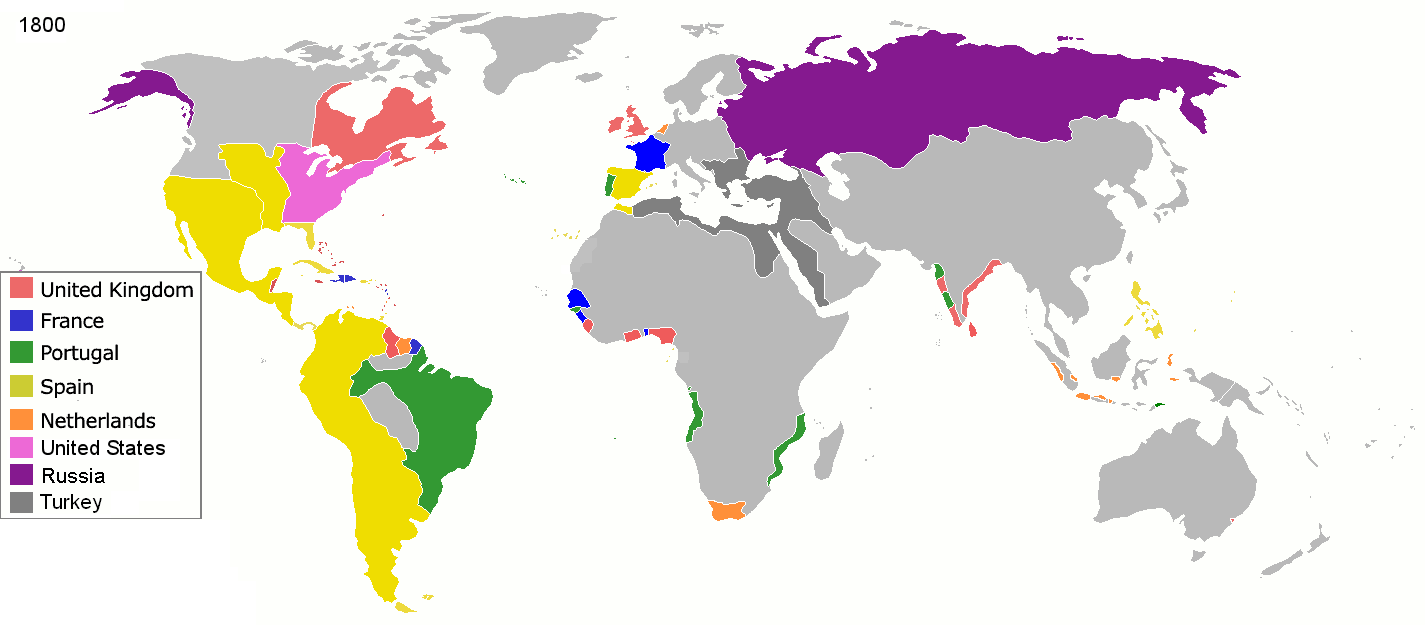
English: Colonial empires in 1800 Français : Empires coloniaux en 1800 Español: Imperios coloniales en 1800 Português: Impérios Coloniais em 1800
|
||||||||||||||||
| Datum | |||||||||||||||||
| Bron | Eigen werk | ||||||||||||||||
| Auteur | Jluisrs | ||||||||||||||||
| Toestemming (Hergebruik van dit bestand) |
|
||||||||||||||||
.jpg)
._LOC_2001620596.jpg)

|
Bestand:Colonial empires in 1800.svg is een vectorversie van dit bestand. Indien niet van slechtere kwaliteit dient deze gebruikt te worden in plaats van deze rasterafbeelding.
File:Colonisation 1800.png → File:Colonial empires in 1800.svg
Zie Help:SVG voor meer informatie.
|
 |
| Aantekeningen InfoField | Deze afbeelding is aangetekend: Bekijk de aantekeningen op Commons |
The extent of British influence in New Zealand in 1800 was the existence of whaling ships and flax traders. Americans and French were also present in New Zealand waters. Missionary presence had not even been established yet, and gun traders weren't significant until about the time of the Musket Wars. New Zealand not British prior to 1840 annexation. However, under the 1788 amended charter of the New South Wales colony, islands adjacent to that region of Australia within the bounds of 10°37'S and 43°39'S are included under it. This includes all but the Southern half of South Island. Recognizing this might be like recognizing the Treaty of Tordesillas on this map, but there is some basis for most of New Zealand being counted as a British colony on this map. (See: http://en.wikipedia.org/wiki/History_of_new_zealand#British_sovereignty, http://en.wikipedia.org/wiki/43rd_parallel_south) Nanib (talk) 19:08, 8 September 2011 (UTC)
Araucania and Patagonia not colonized or occupied by Europeans. Mapuche groups prevented Southward expansion by Spanish. Chile and Argentina began occupying the region from 1843-1902. http://en.wikipedia.org/wiki/Patagonia#Chilean_and_Argentine_expansion_.281843-1902.29
A Norwegian colony existed at Nuuk from 1728. It became Danish in 1814. http://en.wikipedia.org/wiki/Nuuk
Omanese colonies on East African coast from 1698. It might be good to include this, but if the focus of this map is European-related colonies, then it shouldn't be. http://en.wikipedia.org/wiki/Oman#Oman_and_East_Africa
British may have had further holdings in Bengal. http://en.wikipedia.org/wiki/Company_rule_in_India#Expansion_and_territory
Zeila, in Western Somililand, ruled by Ottomans from 1548. http://en.wikipedia.org/wiki/History_of_Somaliland#Ottoman_Somaliland
Dutch Gold Coast from 1598. It might be too small to show. http://en.wikipedia.org/wiki/Dutch_Gold_Coast
The Spanish East Indies in the Pacific. After its discovery in 1521, all of Micronesia was included in the Captaincy General of the Philippines of Spain, but his claim effectively began in 1885, the year in which the Micronesia partitioned between Spain and Germany.
In 1800 the French occupation lasted (http://en.wikipedia.org/wiki/French_campaign_in_Egypt_and_Syria)
Bijschriften
Items getoond in dit bestand
beeldt af
Waarde zonder Wikidata-item
1 mrt 2008
image/png
1c447d15b6569cd35e35abf1b38379514daaa313
42.860 byte
625 pixel
1.425 pixel
Bestandsgeschiedenis
Klik op een datum/tijd om het bestand te zien zoals het destijds was.
| Datum/tijd | Miniatuur | Afmetingen | Gebruiker | Opmerking | |
|---|---|---|---|---|---|
| huidige versie | 1 mei 2016 21:28 | | 1.425 × 625 (42 kB) | Mega-light | Dominican Republic was a French colonia between 1795 and 1808 through Treaty of Basilea. |
| 1 mei 2016 21:21 |  | 1.425 × 625 (42 kB) | Mega-light | Dominican Republic was a French colonia between 1795 and 1808. | |
| 28 sep 2014 01:55 |  | 1.425 × 625 (42 kB) | Leftcry | minor | |
| 16 mei 2013 07:48 |  | 1.425 × 625 (40 kB) | Kraj35 | British settlement in Australia - Sydney and Parramatta. | |
| 16 jan 2012 05:30 |  | 1.425 × 625 (52 kB) | Quigley | cleaner legend | |
| 29 apr 2010 16:07 |  | 1.425 × 625 (49 kB) | Kieran4 | Border changes | |
| 29 apr 2010 16:06 |  | 1.425 × 625 (49 kB) | Kieran4 | Dutch claims in Indonesia were exaggerated and Cape Colony was too small. | |
| 29 apr 2010 16:06 |  | 1.425 × 625 (49 kB) | Kieran4 | Dutch claims in Indonesia were exaggerated and Cape Colony was too small. | |
| 15 feb 2009 18:50 |  | 1.425 × 625 (49 kB) | EuroHistoryTeacher | lousiana was spanish in 1800, would be french officially in 1803 then sold to USA. no spanish settlement in western sahara, or spanish guinea. USA was not a colonisation power. | |
| 21 jan 2009 22:38 |  | 1.425 × 625 (49 kB) | TashkentFox | {{Information |Description= |Source= |Date= |Author= |Permission= |other_versions= }} |
Bestandsgebruik
Dit bestand wordt op de volgende 2 pagina's gebruikt:
Globaal bestandsgebruik
De volgende andere wiki's gebruiken dit bestand:
- Gebruikt op af.wikipedia.org
- Gebruikt op ast.wikipedia.org
- Gebruikt op av.wikipedia.org
- Gebruikt op az.wikipedia.org
- Gebruikt op ba.wikipedia.org
- Gebruikt op be.wikipedia.org
- Gebruikt op ca.wikipedia.org
- Gebruikt op ce.wikipedia.org
- Gebruikt op cs.wikipedia.org
- Gebruikt op da.wikipedia.org
- Gebruikt op en.wikipedia.org
- Gebruikt op eo.wikipedia.org
- Gebruikt op es.wikipedia.org
- Gebruikt op eu.wikipedia.org
- Gebruikt op fi.wikipedia.org
- Gebruikt op fr.wikipedia.org
- Gebruikt op gl.wikipedia.org
- Gebruikt op ha.wikipedia.org
- Gebruikt op he.wikipedia.org
- Gebruikt op hy.wikipedia.org
- Gebruikt op id.wikipedia.org
- Gebruikt op io.wikipedia.org
- Gebruikt op it.wikipedia.org
- Gebruikt op ja.wikipedia.org
- Gebruikt op ka.wikipedia.org
- Gebruikt op meta.wikimedia.org
Globaal gebruik van dit bestand bekijken.
Metadata
Dit bestand bevat metadata met EXIF-informatie, die door een fotocamera, scanner of fotobewerkingsprogramma toegevoegd kan zijn.
| Horizontale resolutie | 37,8 dpc |
|---|---|
| Verticale resolutie | 37,8 dpc |