Attēls:Italy_c_1810.png
From Wikipedia, the free encyclopedia
Šī priekšskata izmērs: 413 × 599 pikseļi. Citi izmēri: 165 × 240 pikseļi | 331 × 480 pikseļi | 529 × 768 pikseļi | 1 251 × 1 814 pikseļi.
Sākotnējais fails (1 251 × 1 814 pikseļi, faila izmērs: 90 KB, MIME tips: image/png)
| Šis fails ir no Vikikrātuves. Tā apraksts no attēla lapas Vikikrātuvē ir parādīts zemāk. Vikikrātuve ir brīvi licencēta failu krātuve. Tu vari tai palīdzēt. |
Satura rādītājs
Kopsavilkums
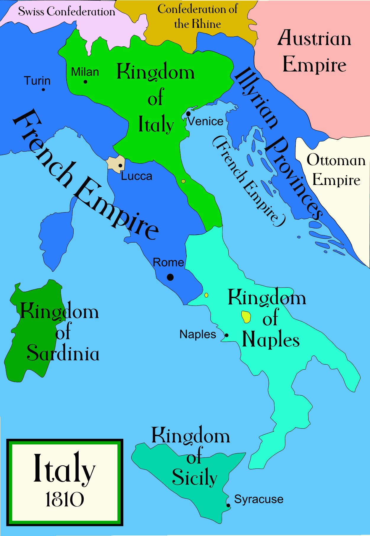
Political map of Italy in the years around 1810, during the Napoleonic era, created by MapMaster. This is a companion map to Image:Italy 1796.png and Image:Italy 1494_v2.png. An SVG version of this map (with Slovenian labels) can be found at Image:Italija_1810_Slovenscina.svg.
Spanish version: File:Italy c 1810-es.png, uploaded by Aibdescalzo

|
This historical map image could be re-created using vector graphics as an SVG file. This has several advantages; see Commons:Media for cleanup for more information. If an SVG form of this image is available, please upload it and afterwards replace this template with
{{vector version available|new image name}}.
It is recommended to name the SVG file “Italy c 1810.svg”—then the template Vector version available (or Vva) does not need the new image name parameter. |
References
- Bjorklund, Oddvar; Holmboe, Haakon; Rohr, Anders (1970) Historical Atlas of the World, Barnes & Noble, NY, SBN: 389-00253-4.
- Other maps, including Image:1french-empire1811.jpg from the 1912 Cambridge Modern History Atlas.
Licence
Es, šī darba autortiesību īpašnieks, publicēju to saskaņā ar šīm licencēm:

|
Ir dota atļauja kopēt, izplatīt un/vai pārveidot šo dokumentu saskaņā ar GNU brīvās dokumentācijas licences, versijas 1.2 vai jebkuras vēlākas versijas, ko publiskojis Brīvās programmatūras fonds nosacījumiem; bez nemainīgajām sadaļā, priekšējā un aizmugurēja'vāka tekstiem. Licences kopija ir iekļauta sadaļā ar nosaukumu GNU brīvās dokumentācijas licence.http://www.gnu.org/copyleft/fdl.htmlGFDLGNU Free Documentation Licensetruetrue |
| Šis fails tiek izplatīts saskaņā ar licences Creative Commons Atsauce-Līdzīgi Noteikumi 3.0 Vispārējiem noteikumiem. | ||
| ||
| This licensing tag was added to this file as part of the GFDL licensing update.http://creativecommons.org/licenses/by-sa/3.0/CC BY-SA 3.0Creative Commons Attribution-Share Alike 3.0truetrue |
Jūs varat izvēlēties licenci pēc jūsu vēlmes.
derivative works
Derivative works of this file:
-
 arābu
arābu -
 angļu
angļu -
 spāņu
spāņu -
 korejiešu


Captions
Pievieno vienas rindiņas aprakstu, ko šis fails attēlo
Šajā failā attēlotais
attēlo
Faila hronoloģija
Uzklikšķini uz datums/laiks kolonnā esošās saites, lai apskatītos, kā šis fails izskatījās tad.
| Datums/Laiks | Attēls | Izmēri | Dalībnieks | Komentārs | |
|---|---|---|---|---|---|
| tagadējais | 2009. gada 21. aprīlis, plkst. 04.32 | | 1 251 × 1 814 (90 KB) | Capmo | pallette reduction to 64 colours |
| 2006. gada 19. oktobris, plkst. 07.01 |  | 1 251 × 1 814 (385 KB) | MapMaster | Further improvements to bring it into line with Image:Italy 1796.png | |
| 2006. gada 13. oktobris, plkst. 15.41 |  | 1 251 × 1 814 (403 KB) | MapMaster | Map was slightly improved. | |
| 2006. gada 13. oktobris, plkst. 15.00 |  | 1 265 × 1 816 (402 KB) | MapMaster | Political map of Italy in the years around 1810, during the Napoleonic era, created by MapMaster. |
Faila lietojums
Šo failu izmanto šajā 1 lapā:
Globālais faila lietojums
Šīs Vikipēdijas izmanto šo failu:
- Izmantojums an.wikipedia.org
- Izmantojums be.wikipedia.org
- Izmantojums br.wikipedia.org
- Izmantojums ceb.wikipedia.org
- Izmantojums cs.wikipedia.org
- Izmantojums da.wikipedia.org
- Izmantojums de.wikipedia.org
- Izmantojums en.wikipedia.org
- Izmantojums eo.wikipedia.org
- Izmantojums es.wikipedia.org
- Izmantojums et.wikipedia.org
- Izmantojums fa.wikipedia.org
- Izmantojums fr.wikipedia.org
- Izmantojums he.wikipedia.org
- Izmantojums hi.wikipedia.org
- Izmantojums hr.wikipedia.org
- Izmantojums hu.wikipedia.org
- Izmantojums id.wikipedia.org
- Izmantojums is.wikipedia.org
- Izmantojums it.wikipedia.org
- Izmantojums ja.wikipedia.org
Skatīt šī faila pilno globālo izmantojumu.
Saturs iegūts no "https://lv.wikipedia.org/wiki/Attēls:Italy_c_1810.png"