File:The_Earth_seen_from_Apollo_17.jpg
Da Wikipedia, l'enciclopedia encyclopedia
File originale (3 000 × 3 002 pixel, dimensione del file: 6,21 MB, tipo MIME: image/jpeg)
| Questo file e la sua pagina di descrizione (discussione · modifica) si trovano su Wikimedia Commons (?) |
Dettagli
| Blue Marble
|
|||||||||||||||||||||||||||||||||||||||||||||||||||||||||||||||
|---|---|---|---|---|---|---|---|---|---|---|---|---|---|---|---|---|---|---|---|---|---|---|---|---|---|---|---|---|---|---|---|---|---|---|---|---|---|---|---|---|---|---|---|---|---|---|---|---|---|---|---|---|---|---|---|---|---|---|---|---|---|---|---|
| Autore |
NASA/Apollo 17 crew; taken by either Harrison Schmitt or Ron Evans |
.jpg) | |||||||||||||||||||||||||||||||||||||||||||||||||||||||||||||
| Fotografo |
|
||||||||||||||||||||||||||||||||||||||||||||||||||||||||||||||
| Titolo |
inglese: The Blue Marble Blue Marble label QS:Lar,"الگُلَّة (البلية) الزرقاء"
label QS:Len,"The Blue Marble" |
||||||||||||||||||||||||||||||||||||||||||||||||||||||||||||||
| Parte di |
Apollo 17 |
||||||||||||||||||||||||||||||||||||||||||||||||||||||||||||||
| Tipo di oggetto |
fotografia |
||||||||||||||||||||||||||||||||||||||||||||||||||||||||||||||
| Genere |
astrofotografia |
||||||||||||||||||||||||||||||||||||||||||||||||||||||||||||||
| Descrizione |
العربية: صورة الگُلَّة (البلية) الزرقاء الشهيرة التي تعتبر أول صورة لمنظر الأرض الكامل. إلتُقطت الصورة في 7 كانون الأوَّل (ديسمبر) 1972 بواسطة طاقم مركبة الفضاء الأمريكيَّة أپولو 17 عند مغادرتهم مدار الأرض لِلقمر من على بعد حوالي 29,400 كيلومتر عن سطح الأرض. إلتقط الطاقم صورة الكوكب الأزرق بِشكلٍ مُتقنٍ حيثُ كانت الشمس من ورائهم وهو ما سمح بِإضائة مُمتازة لِكوكب الأرض، حيثُ تظهر أفريقيا، والقارَّة القطبيَّة الجنوبيَّة (أنتاركتيكا) وشبه الجزيرة العربيَّة.
Deutsch: „Blue Marble“, die während des Fluges von Apollo 17 zum Mond am 7. Dezember 1972 entstandene Fotoaufnahme von der Erde
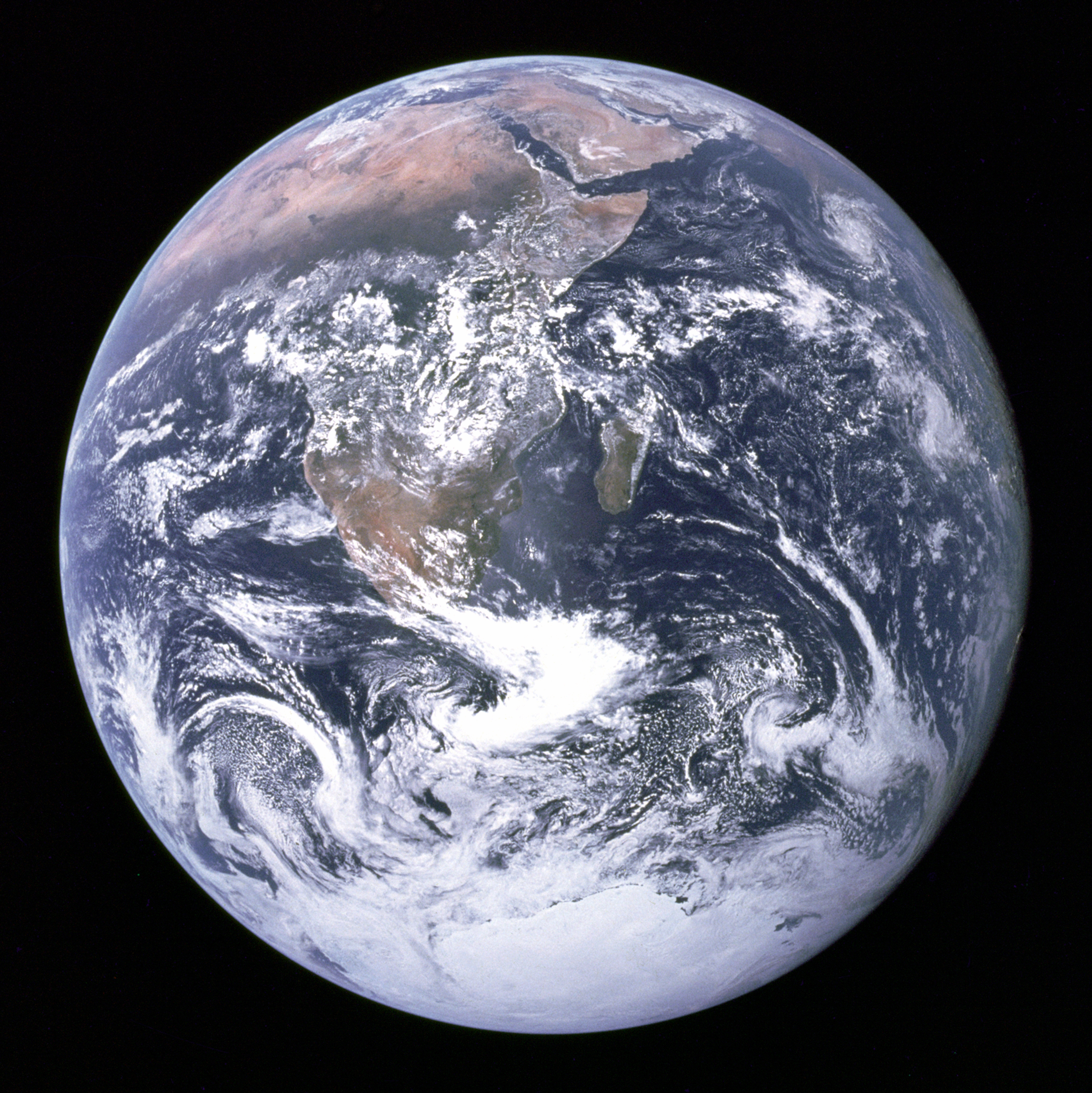
English: "The Blue Marble" is a famous photograph of the Earth taken on December 7, 1972, by the crew of the Apollo 17 spacecraft en route to the Moon at a distance of about 29,400 kilometres (18,300 mi). It shows Africa, Antarctica, and the Arabian Peninsula.
فارسی: «تیلهٔ آبی» تصویر معروفی از زمین که در ۷ دسامبر ۱۹۷۲ توسط خدمهٔ فضاپیمای آپولو ۱۷ در مسیر ماه در حدود ۲٬۹۰۰ کیلومتری زمین گرفته شده است و قسمتهایی از آفریقا، جنوبگان و شبه جزیرهٔ عرب را نشان میدهد.
Suomi: Sininen marmorikuula.
Français : «La bille bleue» : Photo de l'Afrique, de l'Antarctique et de la péninsule Arabique prise en route pour la lune par Harrison Schmitt ou Ron Evans lors de la mission Apollo 17 le 7 décembre 1972. Ce vol a été le dernier à quitter l'orbite terrestre, et le seul au cours duquel un géologue, Harrison Schmitt, s'est rendu sur la lune.
हिन्दी: "द ब्लू मार्बल" लगभग 29,400 kilometres (18,300 mi) की ऊँचाई पर चन्द्रमा की यात्रा पर गये अंतरिक्षयान अपोलो १७ के सदस्यों द्वारा दिसम्बर २००७ को लिया गया प्रसिद्ध चित्र है। इसमें अफ़्रीका, अंटार्कटिका और अरबी प्रायद्वीप दिखाई दे रहे हैं।
Italiano: Famosa fotografia della Terra ripresa il 7 dicembre 1972 dall'equipaggio della missione Apollo 17 diretta verso la Luna, da una distanza di circa 29.400 km.
Magyar: A „Kék üveggolyó”, egy híres fénykép a Földről, amelyet a Hold felé tartó Apollo–17 űrhajó legénysége készített 1972. december 7-én, mintegy 29 ezer kilométer távolságból. Jól látható rajta egész Afrika, az Arab-félsziget és az Antarktisz.
Македонски: „Сината џамлија“ е позната фотографија на Земјата направена на 7 декември 1972 од екипажот на вселенското летало Аполо 17 патувајќи кон Месечината. Сликана е на растојание од 29.400 километри, а на неа се гледаат Африка, Антарктикот и Арапскиот Полуостров.
Português: A Bolinha Azul é uma fotografia famosa da Terra tirada a 7 de dezembro de 1972 durante a missão Apollo 17, quando se encontrava a caminho da Lua e a 29,400 quilómetros da Terra.
Українська: Блакитна іграшкова куля — відома фотографія Землі, зроблена 7 грудня 1972 року командою космічного апарату «Аполлон-17».
中文:蓝色弹珠 是一张在1972年12月7日由阿波罗17号太空船船员所拍摄的著名地球照片。当时太空船正运行至距离地球29,400公里(18,300英里)之处。
日本語: ザ・ブルー・マーブルは、月へ向かうアポロ17号のクルーが1972年12月7日に撮影した有名な地球の写真。29,400km離れた距離から撮影された。アフリカ、アラビア半島、南極大陸、インド洋などを捉えている。
Čeština: Modrá skleněnka je fotografie planety Země, kterou 7. prosince 1972 pořídila posádka Apolla 17 ze vzdálenosti zhruba 29 400 kilometrů. |
||||||||||||||||||||||||||||||||||||||||||||||||||||||||||||||
| Data |
7 dicembre 1972 date QS:P571,+1972-12-07T00:00:00Z/11 |
||||||||||||||||||||||||||||||||||||||||||||||||||||||||||||||
| Fonte | https://web.archive.org/web/20160112123725/http://grin.hq.nasa.gov/ABSTRACTS/GPN-2000-001138.html (image link); see also https://www.nasa.gov/multimedia/imagegallery/image_feature_329.html | ||||||||||||||||||||||||||||||||||||||||||||||||||||||||||||||
| Altre versioni |
[modifica] Other versions:
Derivative works:
|
||||||||||||||||||||||||||||||||||||||||||||||||||||||||||||||


.jpg)
.jpg)


.jpg)


| Posizione del soggetto | 26° 19′ 49″ S, 37° 25′ 13″ E | Posizione di questa e altre immagini su: OpenStreetMap |
|---|
Questa immagine o filmato è stato catalogato dal Johnson Space Center della National Aeronautics and Space Administration (NASA) degli Stati Uniti d'Americacon il Photo ID: AS17-148-22727.Questo tag non indica lo status del copyright dell'opera ad esso associato. È quindi richiesto un normale tag di copyright. Vedi Commons:Licenze per maggiori informazioni. Altre lingue:
العربية ∙ беларуская (тарашкевіца) ∙ български ∙ català ∙ čeština ∙ dansk ∙ Deutsch ∙ English ∙ español ∙ فارسی ∙ français ∙ galego ∙ magyar ∙ հայերեն ∙ Bahasa Indonesia ∙ italiano ∙ 日本語 ∙ македонски ∙ മലയാളം ∙ Nederlands ∙ polski ∙ português ∙ русский ∙ sicilianu ∙ slovenščina ∙ Türkçe ∙ українська ∙ 简体中文 ∙ 繁體中文 ∙ +/− |
Questa immagine o filmato è stato catalogato tra le Great Pictures of NASA della National Aeronautics and Space Administration (NASA) degli Stati Uniti d'Americacon il Photo ID: GPN-2000-001138.Questo tag non indica lo status del copyright dell'opera ad esso associato. È quindi richiesto un normale tag di copyright. Vedi Commons:Licenze per maggiori informazioni. Altre lingue:
العربية ∙ беларуская (тарашкевіца) ∙ български ∙ català ∙ čeština ∙ dansk ∙ Deutsch ∙ English ∙ español ∙ فارسی ∙ français ∙ galego ∙ magyar ∙ հայերեն ∙ Bahasa Indonesia ∙ italiano ∙ 日本語 ∙ македонски ∙ മലയാളം ∙ Nederlands ∙ polski ∙ português ∙ русский ∙ sicilianu ∙ slovenščina ∙ Türkçe ∙ українська ∙ 简体中文 ∙ 繁體中文 ∙ +/− |
Riconoscimenti
|


|
This is one of the images forming part of the Valued image set: Earth from space on Wikimedia Commons. The image set has been assessed under the valued image set criteria and is considered the most valued set on Commons within the scope:
You can see its nomination at Commons:Valued image candidates/Earth from space. |
Questa immagine è stata selezionata come Immagine del giorno in data 20 agosto 2006. La didascalia era la seguente: Altre lingue:
Cymraeg: Y Ddaear, delwedd oddiwrth Apollo 17. Dansk: Jorden set fra Apollo 17 Deutsch: Blick auf die Erde von der Apollo 17. Français : La Terre vue depuis Apollo 17. Galego: The Blue Marble: Fotografía da Terra tomada, o 7 de decembro de 1972, pola tripulación do Apollo 17 na súa ruta cara a Lúa. Mostra África, a Antártida e a península Arábiga. Foi tomada a unha distancia de 45.000 km aproximadamente Português: A Terra vista desde a Apollo 17. Suomi: Apollo 17:n ottama kuva maapallosta. 閩南語 / Bân-lâm-gú: Tiàm Apollo 17-hō thài-kong pe-chûn téng-kôan, iōng thian-bûn-kiàⁿ khòaⁿ tē-kiû ê kéng-tì. العربية : الأرض كما شوهدت من ابولو 17. |
This image was selected as picture of the day on Vietnamese Wikipedia.
|
Questa immagine è stata selezionata come immagine del giorno nella Wikipedia in bengalese.
|
Licenza
| Public domainPublic domainfalsefalse |
| Questo file è nel pubblico dominio perché creato dalla NASA. La politica sul copyright della NASA afferma che «il materiale della NASA non è protetto da copyright a meno che non sia specificato altrimenti». (NASA copyright policy e JPL Image Use Policy). | ||
 |
Attenzione:
|
Additional information
Source: http://nssdc.gsfc.nasa.gov/imgcat/html/object_page/a17_h_148_22727.html
| “ | Earth - Apollo 17
Full Earth showing Africa and Antarctica Apollo 17 hand-held Hasselblad picture of the full Earth. This picture was taken on 7 December 1972, as the spacecraft traveled to the moon as the last of the Apollo missions. A remarkably cloud-free Africa is at upper left, stretching down to the center of the image. Saudi Arabia is visible at the top of the disk and Antarctica and the south pole are at the bottom. Asia is on the horizon is at upper right. The Earth is 12,740 km (7,920 mi) in diameter. (Apollo 17, AS17-148-22727) Location & Time Information |
” |
Didascalie
Elementi ritratti in questo file
raffigura
29 000 chilometro
7 dic 1972
image/jpeg
26°S, 37°E
229ec1e5d613a8c328a1d5955a7abc407e6968b1
6 511 067 byte
3 002 pixel
3 000 pixel
26°19'49.001"S, 37°25'13.001"E
Cronologia del file
Fare clic su un gruppo data/ora per vedere il file come si presentava nel momento indicato.
| Data/Ora | Miniatura | Dimensioni | Utente | Commento | |
|---|---|---|---|---|---|
| attuale | 22:35, 25 set 2020 | | 3 000 × 3 002 (6,21 MB) | Huntster | Reverted to version as of 07:45, 18 December 2012 (UTC); please upload signficantly different versions under a new filename. |
| 20:29, 25 set 2020 |  | 2 500 × 2 500 (8,56 MB) | D2Owiki | Taken from the recent scans from 2015, downloadable for free on the Project Apollo Archive's flickr account. the image is approx. 2500 px. resolution | |
| 09:45, 18 dic 2012 |  | 3 000 × 3 002 (6,21 MB) | Huntster | Reverted to version as of 02:25, 31 July 2005; please do not overwrite featured pictures with modified versions. | |
| 16:11, 17 dic 2012 |  | 2 400 × 2 400 (2,98 MB) | Adzo.1 | Image refaite directement à partir du fichier source NASA AS17-148-22727. | |
| 09:42, 17 ott 2010 |  | 3 000 × 3 002 (6,21 MB) | Huntster | Reverted to version as of 02:25, 31 July 2005; new image is (in my opinion) technically inferior to the July 2005 image, and is not the featured picture that was voted upon. Upload new image to another filename if desired. | |
| 08:16, 17 ott 2010 |  | 3 720 × 3 796 (10,46 MB) | Jeff G. | *Higher-quality and higher-resolution image: apollo17_earth.tiff as contained by ftp://nssdcftp.gsfc.nasa.gov/photo_gallery/hi-res/planetary/earth/apollo17_earth.tiff.gz and converted to JPEG with 100% quality using [[w:Paint.NET|Paint.NET v3.5 | |
| 04:25, 31 lug 2005 |  | 3 000 × 3 002 (6,21 MB) | Tom | larger image | |
| 00:41, 30 dic 2004 |  | 1 860 × 1 898 (762 KB) | Ed g2s | {{PD-USGov-NASA}} |
Pagine che usano questo file
Più di 100 pagine usano questo file. Di seguito sono elencate solo le prime 100 pagine che usano questo file. È disponibile un elenco completo.
- Abitabilità planetaria
- Acqua
- Ambientalismo
- Ambiente (biologia)
- Analisi delle Operette morali
- Blue Marble
- Cambiamento climatico
- Clima terrestre
- Cronologia della scoperta di pianeti e satelliti del Sistema solare
- Etica mondiale
- Formazione della Terra
- Fotografia
- Futuro della Terra
- Giornata mondiale dell'acqua
- Ipotesi Gaia
- Origine della vita
- Parametri orbitali della Terra
- Pianeta
- Polo sud
- Programma Apollo
- Raggio terrestre
- Risorse idriche
- Sistema solare
- Utente:Aby99
- Utente:Ale91ale91
- Utente:Alex3
- Utente:Andie
- Utente:Andie/Babel
- Utente:Andrea.dematteis.1987
- Utente:Bedo2991
- Utente:Bello1989
- Utente:Bender82
- Utente:Betta27
- Utente:Cartoonman
- Utente:Cartoonman/Babel
- Utente:Ciosl
- Utente:DaP/Sandbox5
- Utente:Danielwik
- Utente:Enpi/Archivio 2008
- Utente:Er Cicero
- Utente:Eremdaviq
- Utente:Fontema
- Utente:GBMorgagni
- Utente:Giacomo Vitali
- Utente:Giornada
- Utente:Giuliano56
- Utente:Henrykus/Portale sistemi planetari
- Utente:Henrykus/Portale sistemi planetari/Galleria
- Utente:IlPozz
- Utente:JingleBellsAssassino
- Utente:Kalibos/sandbox
- Utente:Lawans
- Utente:Lawrel
- Utente:Lord Bacco
- Utente:Loroschi
- Utente:Lory994
- Utente:Manuelarosi
- Utente:Mathematich
- Utente:Matra dj
- Utente:Metal83
- Utente:Michyfog
- Utente:Miloled
- Utente:Mister Ics
- Utente:Montagnapistoiese
- Utente:Nase
- Utente:Neptunerover
- Utente:Newbios71
- Utente:Nicky 94
- Utente:Pazcal
- Utente:Pinkadilly
- Utente:ReN8
- Utente:Ron Paul
- Utente:RuandaBit
- Utente:RuandaBit/Babelfish
- Utente:RuandaBit/Pagina principale
- Utente:Sedicinoni
- Utente:Sedimentaryrock
- Utente:Sono Un Uomo
- Utente:Sono Un Uomo/Babelfish
- Utente:Sono Un Uomo/Bozza
- Utente:Supermary
- Utente:Talmid3
- Utente:TheOnlyGod
- Utente:Titanomachia78
- Utente:Tosão
- Utente:Wikiar
- Utente:Xavier121/Sandbox2
- Utente:Zuzu macumba
- Wikipedia:Localismo
- Wikipedia:Scherzi e STUBidaggini/Ranking dei paesini sconosciuti
- Template:Terra
- Portale:Ecologia e ambiente/Biografia/2
- Portale:Geologia
- Portale:Geologia/Evidenza
- Portale:Scienze della Terra/Vetrina
- Portale:Sistema solare
- Portale:Sistema solare/Galleria
- Progetto:Fisica/Immagini
- Progetto:Scienze della Terra
- Progetto:Scienze della Terra/Vetrina
Visualizza altri collegamenti a questo file.
Utilizzo globale del file
Anche i seguenti wiki usano questo file:
- Usato nelle seguenti pagine di ab.wikipedia.org:
- Usato nelle seguenti pagine di af.wikipedia.org:
- Aarde
- Sonnestelsel
- Water
- Melkweg
- Plaaslike Borrel
- Aardverwarming
- Gebruiker:Anrie/Spogbeelde
- Wikipedia:Voorbladartikels 2009
- Wikipedia:Voorbladbeeld week 2 2009
- Heelal
- Wikipedia:Beeld van die week/2009
- Wikipedia:Voorbladartikel week 50 2009
- Werklikheid
- Wikipedia:Voorbladartikels 2012
- Lewe
- Wikipedia:Voorbladartikel week 23 2012
- Multiversum
- Plaaslike Groep
- Virgo-superswerm
- Lys van Melkweg se satelliet-sterrestelsels
- Orion-Cygnus-arm
- Gaia-hipotese
- Seldsame Aarde-hipotese
- Sjabloon:Aarde-posisie
- Plaaslike Interstellêre Wolk
- Laniakea-superswerm
- Gould-gordel
- Ouderdom van die Aarde
- Wikipedia:Voorbladartikels 2017
- Wikipedia:Voorbladartikel week 18 2017
- Wikipedia:Voorbladartikels 2018
- Wikipedia:Voorbladartikel week 8 2018
- Ruimteverkenning
- Sigbare heelal
- Vroegste bekende lewensvorme
- Sjabloon:LeweOpAarde
- Usato nelle seguenti pagine di als.wikipedia.org:
- Usato nelle seguenti pagine di alt.wikipedia.org:
- Usato nelle seguenti pagine di ang.wikipedia.org:
- Usato nelle seguenti pagine di ang.wikibooks.org:
Visualizza l'utilizzo globale di questo file.
Metadati
Questo file contiene informazioni aggiuntive, probabilmente aggiunte dalla fotocamera o dallo scanner usati per crearlo o digitalizzarlo. Se il file è stato modificato, alcuni dettagli potrebbero non corrispondere alla realtà.
| Orientamento | Normale |
|---|---|
| Risoluzione orizzontale | 300 punti per pollice (dpi) |
| Risoluzione verticale | 300 punti per pollice (dpi) |
| Software | Adobe Photoshop CS Windows |
| Data e ora di modifica del file | 13:09, 13 mag 2005 |
| Spazio dei colori | sRGB |
| Larghezza immagine | 3 000 px |
| Altezza immagine | 3 002 px |
| Data e ora di digitalizzazione | 08:09, 13 mag 2005 |
| Data in cui i metadata sono stati modificati l'ultima volta | 08:09, 13 mag 2005 |