File:North_America_from_low_orbiting_satellite_Suomi_NPP.jpg
Da Wikipedia, l'enciclopedia encyclopedia
File originale (8 000 × 8 000 pixel, dimensione del file: 16,43 MB, tipo MIME: image/jpeg)
| Questo file e la sua pagina di descrizione (discussione · modifica) si trovano su Wikimedia Commons (?) |
Dettagli
| Attenzione | Alcuni browser potrebbero avere dei problemi nel mostrare questa immagine a piena risoluzione: questa immagine è composta da un numero insolitamente alto di pixel e potrebbe non essere visualizzata correttamente o causare l'arresto del browser. | Open large-image-viewer |
|---|
| DescrizioneNorth America from low orbiting satellite Suomi NPP.jpg |
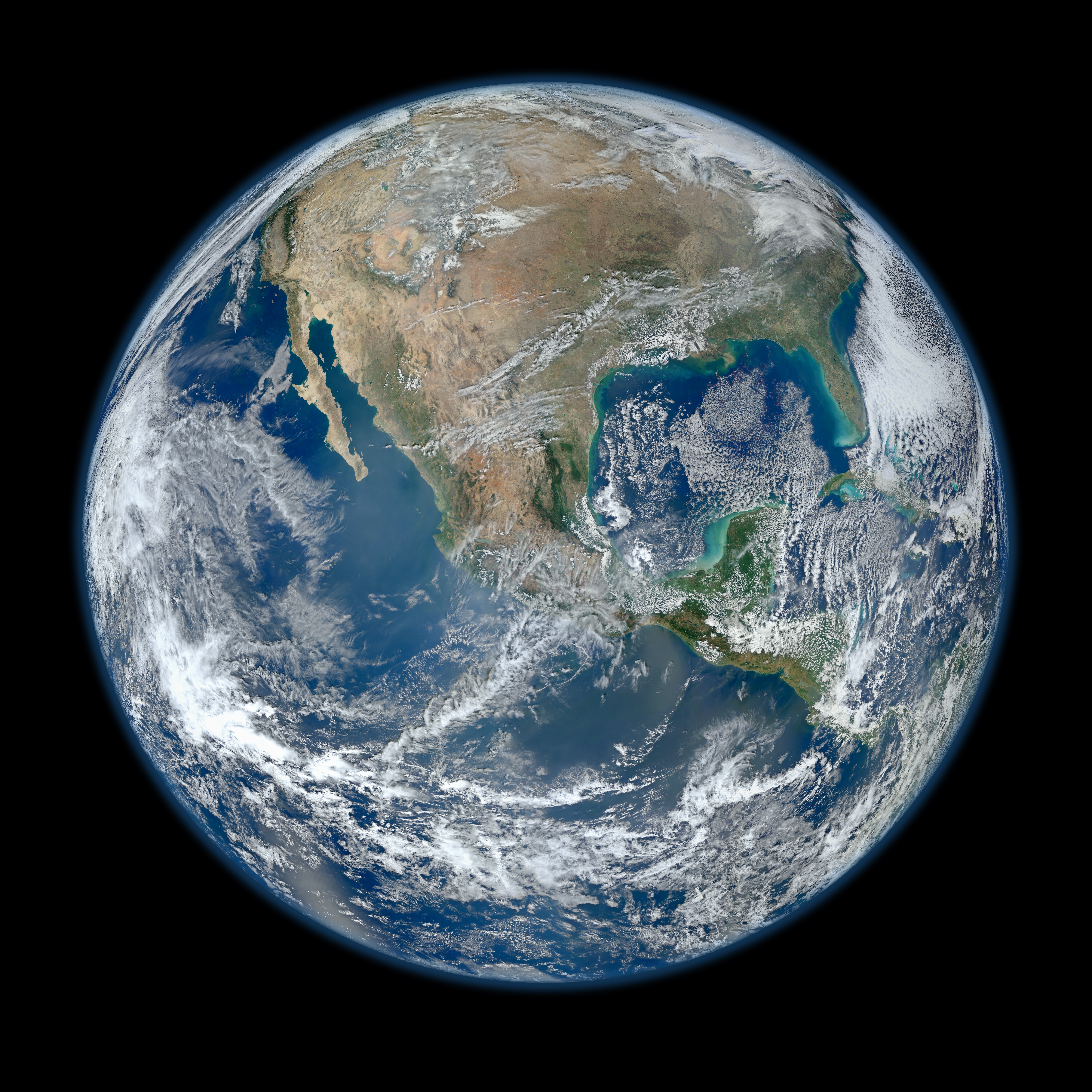
English: A view of most of North America taken from a low orbit of about 826 km altitude. The whole hemisphere is not visible owing to the low orbit, and the horizon is at a distance of about 3,300 km, while the radius of the planet is 6,371 km. The diameter seen from this height is about 125 degrees.
An image of the Earth taken from the VIIRS instrument aboard NASA's Earth-observing research satellite, Suomi NPP. This composite image uses a number of swaths of the Earth's surface taken on 4 January 2012. The NPP satellite was renamed 'Suomi NPP' on 24 January 2012 to honour the late Verner E. Suomi of the University of Wisconsin. Suomi NPP carries five instruments on board. The biggest and most important instrument is The Visible/Infrared Imager Radiometer Suite or VIIRS.
Español: Una vista de la mayor parte de América del Norte tomada desde una órbita baja. Esta vista resulta de una altura del satélite que está a unos 826 kilómetros por encima de la superficie de la Tierra. Debido a la órbita baja el hemisferio no es totalmente visible, y el horizonte se encuentra en una distancia de tan sólo aproximadamente 3300 km, mientras que el radio de nuestro planeta es 6371 kilómetros. El diámetro del horizonte visto desde esta altura es de aproximadamente 125 grados. |
||||
| Data | |||||
| Fonte |
http://www.nasa.gov/multimedia/imagegallery/image_feature_2159.html; SEE Also => http://solarsystem.nasa.gov/multimedia/display.cfm?IM_ID=9643 AND http://solarsystem.nasa.gov/planets/profile.cfm?Object=Earth |
||||
| Autore | NASA/NOAA/GSFC/Suomi NPP/VIIRS/Norman Kuring | ||||
| Altre versioni |
|

.jpg)
|
Questa immagine è stata selezionata come Immagine del giorno in data 22 aprile 2014. La didascalia era la seguente: Italiano: L'America settentrionale fotografata in orbita bassa nella Giornata della Terra dal satellite di ricerca Suomi NPP. Altre lingue:
Bosanski: Fotografija načinjena na Dan planete Zemlje, pogled na veći dio Sjeverne Amerike iz niske orbite od oko 826 km iznad površine iz NASA-inog satelita za istraživanje Zemlje Suomi NPP. Čeština: Na dnešní den: Den Země, pohled na Severní Ameriku z nízké oběžné dráhy z výšky kolem 826 km, snímek z meteorologického satelitu Suomi NPP. English: On Earth Day, a view of most of North America taken from a low orbit of about 826 km altitude aboard NASA's Earth-observing research satellite, Suomi NPP. Italiano: L'America settentrionale fotografata in orbita bassa nella Giornata della Terra dal satellite di ricerca Suomi NPP. Magyar: A Föld napja: Észak-Amerika nagyobb részének képe, amely a NASA egyik alacsony pályán, mintegy 826 km magasságban keringő Föld-megfigyelő műholdjáról, a Suomi NPP-ről készült Nederlands: Op de Dag van de Aarde een blik op Noord-Amerika vanaf een lage baan op 826 kilometer hoogte vanuit de NASA-satelliet Suomi NPP. 中文: 世界地球日,美国宇航局的地球观测卫星在低轨道826公里处拍摄的北美洲大部分地区的照片。 |
Licenza
| Public domainPublic domainfalsefalse |
| Questo file è nel pubblico dominio perché creato dalla NASA. La politica sul copyright della NASA afferma che «il materiale della NASA non è protetto da copyright a meno che non sia specificato altrimenti». (NASA copyright policy e JPL Image Use Policy). | ||
 |
Attenzione:
|
Didascalie
4 gen 2012
image/jpeg
Cronologia del file
Fare clic su un gruppo data/ora per vedere il file come si presentava nel momento indicato.
| Data/Ora | Miniatura | Dimensioni | Utente | Commento | |
|---|---|---|---|---|---|
| attuale | 06:03, 26 gen 2012 | | 8 000 × 8 000 (16,43 MB) | Hellbus | {{Information |Description ={{en|1=A 'Blue Marble' image of the Earth taken from the VIIRS instrument aboard NASA's most recently launched Earth-observing satellite - Suomi NPP. This composite image uses a number of swaths of the Earth's surface taken |
Pagine che usano questo file
Le seguenti 3 pagine usano questo file:
Utilizzo globale del file
Anche i seguenti wiki usano questo file:
- Usato nelle seguenti pagine di af.wikipedia.org:
- Usato nelle seguenti pagine di ar.wikipedia.org:
- Usato nelle seguenti pagine di as.wikipedia.org:
- Usato nelle seguenti pagine di az.wikiquote.org:
- Usato nelle seguenti pagine di be-tarask.wikipedia.org:
- Usato nelle seguenti pagine di bn.wikipedia.org:
- Usato nelle seguenti pagine di crh.wikipedia.org:
- Usato nelle seguenti pagine di cv.wikipedia.org:
- Usato nelle seguenti pagine di de.wikipedia.org:
- Usato nelle seguenti pagine di el.wikipedia.org:
- Usato nelle seguenti pagine di en.wikipedia.org:
- The Blue Marble
- Portal:Energy
- Portal:Energy/Energy topics
- User:Northamerica1000
- Portal:Society/Featured article
- User talk:Semccraw
- User talk:Jesusserrano
- User talk:Bmbrooks
- User talk:Bhaluska
- User talk:Ependell
- User talk:Mmutterperl
- User talk:Kaylaek
- User talk:Tjohns17
- User talk:BellaBeast
- User talk:JessicaSG
- User talk:Laurenm2
- User talk:Jessgutman
- User talk:Lissyh1990
- User talk:Maxsasaki
- User talk:Aebarone
- User talk:Emackin
- User talk:Lmfye
- User talk:EauroraUA
- User talk:Jaallen1
- User talk:Dkunst
- User talk:Girg45
- User talk:Cindyy1
- User talk:Aglick
- Suomi NPP
- User:Cullen328/Welcome
- Wikipedia:Featured picture candidates/February-2012
- User talk:Sdmuszyn
- User talk:Allieglock
- User talk:Cpatel623
- User talk:Darrinbrink
Visualizza l'utilizzo globale di questo file.
Metadati
Questo file contiene informazioni aggiuntive, probabilmente aggiunte dalla fotocamera o dallo scanner usati per crearlo o digitalizzarlo. Se il file è stato modificato, alcuni dettagli potrebbero non corrispondere alla realtà.
| Commento del file JPEG | Satellite: NPP
Sensor: VIIRS Date: 4 January 2012 Description: Perspective view of North and Central America Red channel: Band 5 (662-682 nm) Green channel: Band 4 (545-565 nm) Blue channel: Band 2 (436-454 nm) Projection: Near-sided perspective from 2124 kilometers above 20 North by 100 West Author: Norman Kuring Created: 2012-01-20T21:00:00Z |
|---|