File:Earth's_City_Lights_by_DMSP,_1994-1995_(medium).png
Da Wikipedia, l'enciclopedia encyclopedia
File originale (2 560 × 1 280 pixel, dimensione del file: 2,56 MB, tipo MIME: image/png)
| Questo file e la sua pagina di descrizione (discussione · modifica) si trovano su Wikimedia Commons (?) |
Dettagli
| DescrizioneEarth's City Lights by DMSP, 1994-1995 (medium).png |
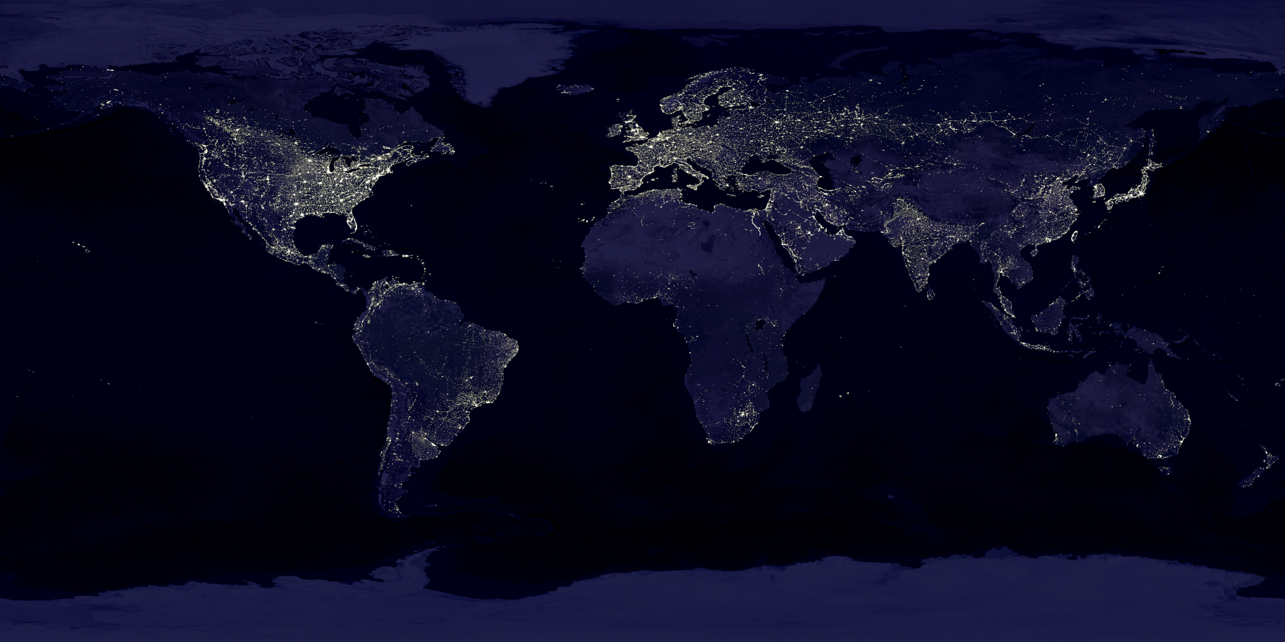
English: This image of Earth’s city lights was created with data from the Defense Meteorological Satellite Program (DMSP) Operational Linescan System (OLS). Originally designed to view clouds by moonlight, the OLS is also used to map the locations of permanent lights on the Earth’s surface.
The brightest areas of the Earth are the most urbanized, but not necessarily the most populated. (Compare western Europe with China and India.) Cities tend to grow along coastlines and transportation networks. Even without the underlying map, the outlines of many continents would still be visible. The United States interstate highway system appears as a lattice connecting the brighter dots of city centers. In Russia, the Trans-Siberian railroad is a thin line stretching from Moscow through the center of Asia to Vladivostok. The Nile River, from the Aswan Dam to the Mediterranean Sea, is another bright thread through an otherwise dark region. Even more than 100 years after the invention of the electric light, some regions remain thinly populated and unlit. Antarctica is entirely dark. The interior jungles of Africa and South America are mostly dark, but lights are beginning to appear there. Deserts in Africa, Arabia, Australia, Mongolia, and the United States are poorly lit as well (except along the coast), along with the boreal forests of Canada and Russia, and the great mountains of the Himalaya. |
| Data |
tra il 1 ottobre 1994 e il 31 marzo 1995 date QS:P,+1994-00-00T00:00:00Z/8,P1319,+1994-10-01T00:00:00Z/11,P1326,+1995-03-31T00:00:00Z/11 |
| Fonte | https://visibleearth.nasa.gov/view.php?id=55167 (image link) |
| Autore | Data: Marc Imhoff/NASA GSFC, Christopher Elvidge/NOAA NGDC; Image: Craig Mayhew and Robert Simmon/NASA GSFC |
| Altre versioni |
|
.jpg)
.jpg)
.png)

Licenza
| Public domainPublic domainfalsefalse |
| Questo file è nel pubblico dominio perché creato dalla NASA. La politica sul copyright della NASA afferma che «il materiale della NASA non è protetto da copyright a meno che non sia specificato altrimenti». (NASA copyright policy e JPL Image Use Policy). | ||
 |
Attenzione:
|
| Public domainPublic domainfalsefalse |
Questa immagine o file multimediale è di pubblico dominio poiché contiene materiale proveniente della National Oceanic and Atmospheric Administration, realizzato da personale dipendente durante l'assolvimento dei propri compiti ufficiali.
العربية ∙ čeština ∙ Deutsch ∙ Zazaki ∙ English ∙ español ∙ eesti ∙ suomi ∙ français ∙ hrvatski ∙ magyar ∙ italiano ∙ 日本語 ∙ 한국어 ∙ македонски ∙ മലയാളം ∙ Plattdüütsch ∙ Nederlands ∙ polski ∙ português ∙ română ∙ русский ∙ sicilianu ∙ slovenščina ∙ Türkçe ∙ Tiếng Việt ∙ 简体中文 ∙ 繁體中文 ∙ +/− |
Didascalie
Elementi ritratti in questo file
raffigura
image/png
Cronologia del file
Fare clic su un gruppo data/ora per vedere il file come si presentava nel momento indicato.
| Data/Ora | Miniatura | Dimensioni | Utente | Commento | |
|---|---|---|---|---|---|
| attuale | 20:49, 15 apr 2017 | | 2 560 × 1 280 (2,56 MB) | Huntster | Standardise appearance in series. |
| 22:45, 9 mar 2009 |  | 2 560 × 1 364 (2,18 MB) | Tryphon | Higher resolution. | |
| 17:05, 18 set 2007 |  | 1 499 × 797 (658 KB) | Jonathan Kovaciny~commonswiki | Re-cropped version of original NASA image. | |
| 17:03, 18 set 2007 |  | 1 521 × 797 (667 KB) | Jonathan Kovaciny~commonswiki | Cropped version of the original NASA image. | |
| 18:26, 30 mar 2007 |  | 1 500 × 1 125 (1,61 MB) | Laur2ro | {{Information |Description=Earth lights, image is slightly edited (increased contrast and brightness; similar to Image:Whole world - at night.png, but the continents are visible also). |Source=http://visibleearth.nasa.gov/view_rec.php?id=11793 |Date=m |
Pagine che usano questo file
La seguente pagina usa questo file:
Utilizzo globale del file
Anche i seguenti wiki usano questo file:
- Usato nelle seguenti pagine di ar.wikipedia.org:
- Usato nelle seguenti pagine di ca.wikipedia.org:
- Usato nelle seguenti pagine di en.wikipedia.org:
- Usato nelle seguenti pagine di en.wikiquote.org:
- Usato nelle seguenti pagine di en.wikiversity.org:
- Usato nelle seguenti pagine di es.wikinews.org:
- Usato nelle seguenti pagine di fr.wikipedia.org:
- Usato nelle seguenti pagine di fr.wikiversity.org:
- Usato nelle seguenti pagine di ha.wikipedia.org:
- Usato nelle seguenti pagine di hi.wikipedia.org:
- Usato nelle seguenti pagine di hr.wikipedia.org:
- Usato nelle seguenti pagine di mwl.wikipedia.org:
- Usato nelle seguenti pagine di pl.wikipedia.org:
- Usato nelle seguenti pagine di ru.wikipedia.org:
- Usato nelle seguenti pagine di sh.wikipedia.org:
- Usato nelle seguenti pagine di uk.wikipedia.org:
- Usato nelle seguenti pagine di uz.wikipedia.org:
- Usato nelle seguenti pagine di www.wikidata.org:
Metadati
Questo file contiene informazioni aggiuntive, probabilmente aggiunte dalla fotocamera o dallo scanner usati per crearlo o digitalizzarlo. Se il file è stato modificato, alcuni dettagli potrebbero non corrispondere alla realtà.
| Data e ora di modifica del file | 18:47, 15 apr 2017 |
|---|---|
| Risoluzione orizzontale | 15,11 punti per centimetro (dpc) |
| Risoluzione verticale | 15,11 punti per centimetro (dpc) |