File:Americas_satellite_map.jpg
Da Wikipedia, l'enciclopedia encyclopedia
File originale (2 300 × 2 900 pixel, dimensione del file: 1,87 MB, tipo MIME: image/jpeg)
| Questo file e la sua pagina di descrizione (discussione · modifica) si trovano su Wikimedia Commons (?) |
Dettagli
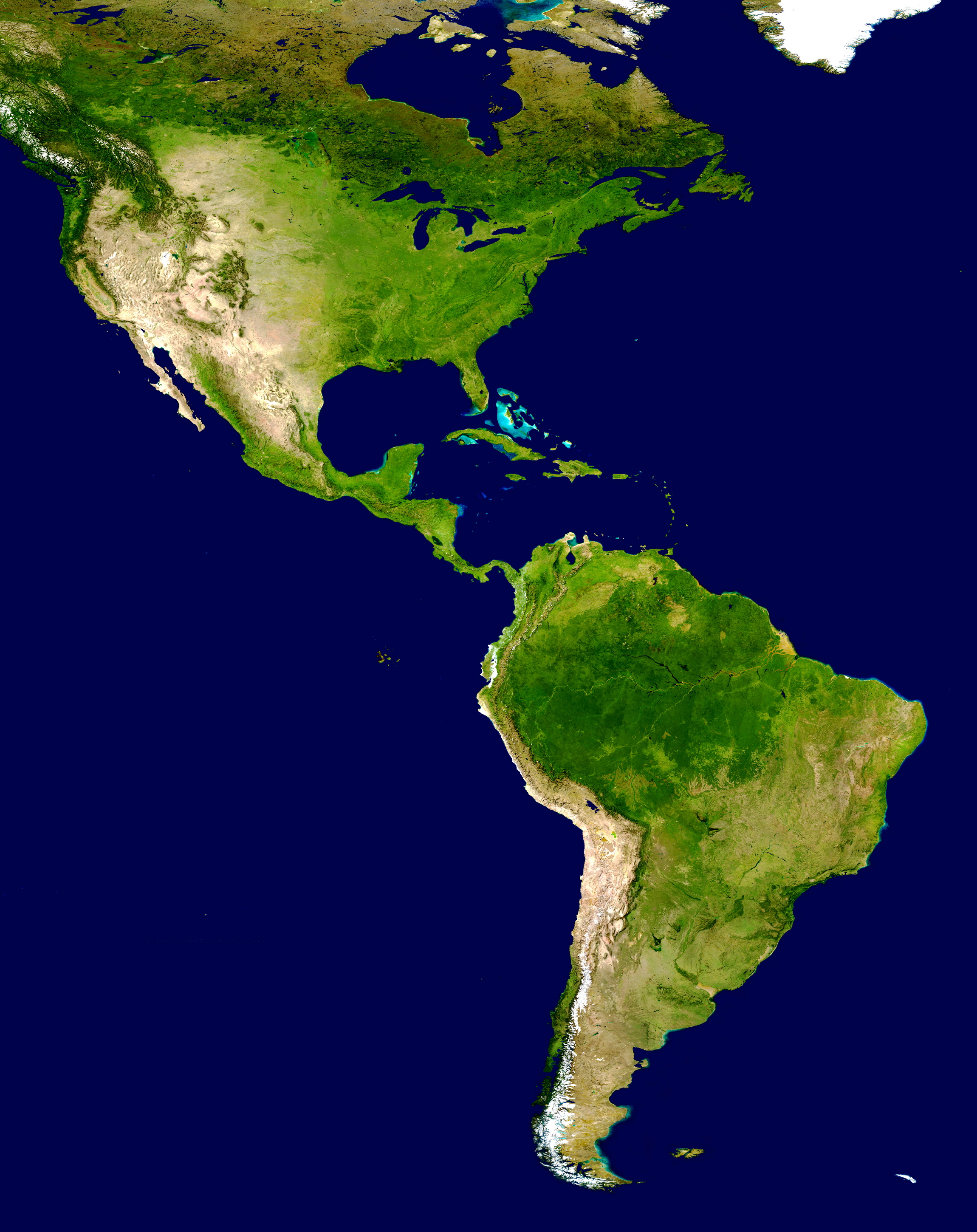
| DescrizioneAmericas satellite map.jpg |
NASA's description of the original non-cropped imageː "This spectacular “blue marble” image is the most detailed true-color image of the entire Earth to date. Using a collection of satellite-based observations, scientists and visualizers stitched together months of observations of the land surface, oceans, sea ice, and clouds into a seamless, true-color mosaic of every square kilometer (.386 square mile) of our planet. These images are freely available to educators, scientists, museums, and the public. This record includes preview images and links to full resolution versions up to 21,600 pixels across. Much of the information contained in this image came from a single remote-sensing device-NASA’s Moderate Resolution Imaging Spectroradiometer, or MODIS. Flying over 700 km above the Earth onboard the Terra satellite, MODIS provides an integrated tool for observing a variety of terrestrial, oceanic, and atmospheric features of the Earth. The land and coastal ocean portions of these images are based on surface observations collected from June through September 2001 and combined, or composited, every eight days to compensate for clouds that might block the sensor’s view of the surface on any single day. Two different types of ocean data were used in these images: shallow water true color data, and global ocean color (or chlorophyll) data. Topographic shading is based on the GTOPO 30 elevation dataset compiled by the U.S. Geological Survey’s EROS Data Center. MODIS observations of polar sea ice were combined with observations of Antarctica made by the National Oceanic and Atmospheric Administration’s AVHRR sensor—the Advanced Very High Resolution Radiometer. The cloud image is a composite of two days of imagery collected in visible light wavelengths and a third day of thermal infra-red imagery over the poles. Global city lights, derived from 9 months of observations from the Defense Meteorological Satellite Program, are superimposed on a darkened land surface map." The 8192 x 4096 TIFF NASA global map has been cropped, adjusted in brightness, and converted to JPEG. |
| Data | |
| Fonte | http://visibleearth.nasa.gov/view_rec.php?id=2433 |
| Autore | NASA |
| Altre versioni | Opere derivate da questo file: Distribution of P. peckolti.jpg |
Licenza
| Public domainPublic domainfalsefalse |
| Questo file è nel pubblico dominio perché creato dalla NASA. La politica sul copyright della NASA afferma che «il materiale della NASA non è protetto da copyright a meno che non sia specificato altrimenti». (NASA copyright policy e JPL Image Use Policy). | ||
 |
Attenzione:
|
Didascalie
Elementi ritratti in questo file
raffigura
settembre 2001
image/jpeg
414401b78c1c95749a0b485b262f063cbfb3be6a
1 958 581 byte
2 900 pixel
2 300 pixel
Cronologia del file
Fare clic su un gruppo data/ora per vedere il file come si presentava nel momento indicato.
| Data/Ora | Miniatura | Dimensioni | Utente | Commento | |
|---|---|---|---|---|---|
| attuale | 19:23, 28 giu 2008 | | 2 300 × 2 900 (1,87 MB) | WolfmanSF | {{Information |Description=This spectacular “blue marble” image is the most detailed true-color image of the entire Earth to date. Using a collection of satellite-based observations, scientists and visualizers stitched together months of observations |
| 21:54, 30 dic 2007 |  | 2 300 × 2 900 (1,93 MB) | WolfmanSF | {{Information |Description=This spectacular “blue marble” image is the most detailed true-color image of the entire Earth to date. Using a collection of satellite-based observations, scientists and visualizers stitched together months of observations |
Pagine che usano questo file
Le seguenti 3 pagine usano questo file:
Utilizzo globale del file
Anche i seguenti wiki usano questo file:
- Usato nelle seguenti pagine di ar.wikipedia.org:
- Usato nelle seguenti pagine di bn.wikipedia.org:
- Usato nelle seguenti pagine di ca.wikipedia.org:
- Usato nelle seguenti pagine di ca.wikiquote.org:
- Usato nelle seguenti pagine di ckb.wikipedia.org:
- Usato nelle seguenti pagine di en.wikipedia.org:
- Usato nelle seguenti pagine di es.wikipedia.org:
- América del Norte
- Colombia
- Haití
- Dominica
- Portal:Geografía/Titular
- Comando Sur de Estados Unidos
- Portal:América
- Policía Nacional de la República Dominicana
- Wikiproyecto:América del Sur/Proyectos hermanos
- Anexo:Supercentenarios latinoamericanos
- Categoría:Elecciones en América en 1993
- Categoría:Elecciones en América en 1913
- Categoría:Elecciones en América en 1992
- Categoría:Elecciones en América en 1996
- Categoría:Elecciones en América en 1995
- Categoría:Elecciones en América en 1997
- Categoría:Elecciones en América en 1994
- Categoría:Elecciones en América en 1965
- Categoría:Elecciones en América en 1960
- Anexo:Imperios americanos
- Categoría:Elecciones en América en 1991
- Categoría:Elecciones en América en 1990
- Categoría:Elecciones en América en 1989
- Categoría:Elecciones en América en 1988
- Categoría:Elecciones en América en 1987
- Categoría:Elecciones en América en 1985
- Categoría:Elecciones en América en 1984
- Categoría:Elecciones en América en 1983
- Categoría:Elecciones en América en 1915
- Categoría:Elecciones en América en 1937
- Usato nelle seguenti pagine di es.wikivoyage.org:
- Usato nelle seguenti pagine di eu.wikipedia.org:
- Usato nelle seguenti pagine di fa.wikipedia.org:
- Usato nelle seguenti pagine di ff.wikipedia.org:
Visualizza l'utilizzo globale di questo file.
Metadati
Questo file contiene informazioni aggiuntive, probabilmente aggiunte dalla fotocamera o dallo scanner usati per crearlo o digitalizzarlo. Se il file è stato modificato, alcuni dettagli potrebbero non corrispondere alla realtà.
| Commento del file JPEG | AppleMark |
|---|---|
| Orientamento | Normale |
| Risoluzione orizzontale | 72 punti per pollice (dpi) |
| Risoluzione verticale | 72 punti per pollice (dpi) |
| Software | QuickTime 7.5 |
| Data e ora di modifica del file | 10:02, 28 giu 2008 |
| Posizionamento componenti Y e C | Centrato |
| Versione del formato Exif | 2.2 |
| Spazio dei colori | Non calibrato |