
Wilkes-Barre/Scranton International Airport
Airport in Pennsylvania, U.S. / From Wikipedia, the free encyclopedia
Dear Wikiwand AI, let's keep it short by simply answering these key questions:
Can you list the top facts and stats about Wilkes-Barre/Scranton International Airport?
Summarize this article for a 10 year old
SHOW ALL QUESTIONS
Wilkes-Barre/Scranton International Airport (IATA: AVP, ICAO: KAVP, FAA LID: AVP) is mostly in Pittston Township, Pennsylvania, about 7 miles (11 km) from Scranton and 8 mi (13 km) from Wilkes-Barre. It spans the border between Luzerne County and Lackawanna County, and is owned and operated by the two counties. It is the fifth-largest airport in Pennsylvania by passenger count and calls itself "your gateway to Northeastern Pennsylvania and the Pocono Mountains".[3]
Quick Facts Summary, Airport type ...
Wilkes-Barre/Scranton International Airport | |||||||||||||||
|---|---|---|---|---|---|---|---|---|---|---|---|---|---|---|---|
| Summary | |||||||||||||||
| Airport type | Public | ||||||||||||||
| Owner/Operator | Luzerne and Lackawanna Counties | ||||||||||||||
| Serves | Wilkes-Barre–Scranton-Wyoming Valley | ||||||||||||||
| Location | Pittston Township, Pennsylvania, U.S. | ||||||||||||||
| Elevation AMSL | 962 ft / 293 m | ||||||||||||||
| Coordinates | 41°20′18″N 075°43′24″W | ||||||||||||||
| Website | www.FlyAVP.com | ||||||||||||||
| Maps | |||||||||||||||
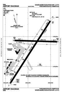 FAA airport diagram as of January 2021 | |||||||||||||||
 | |||||||||||||||
| Runways | |||||||||||||||
| |||||||||||||||
| Statistics (2021) | |||||||||||||||
| |||||||||||||||
Close