Portal:Siberia
Wikipedia portal for content related to Siberia / From Wikipedia, the free encyclopedia
Portal maintenance status: (November 2020)
|
Siberia | |
|---|---|
Geographical region | |
 Siberian Federal District |
The Siberia Portal
A portal dedicated to Siberia
Introduction
Siberia (/saɪˈbɪəriə/ sy-BEER-ee-ə; Russian: Сибирь, romanized: Sibir', IPA: [sʲɪˈbʲirʲ] ⓘ) is an extensive geographical region comprising all of North Asia, from the Ural Mountains in the west to the Pacific Ocean in the east. It has formed part of the sovereign territory of Russia and its predecessor states since the centuries-long conquest of Siberia, which began with the fall of the Khanate of Sibir in the late 16th century and concluded with the annexation of Chukotka in 1778. Siberia is vast and sparsely populated, covering an area of over 13.1 million square kilometres (5,100,000 sq mi), but home to roughly a quarter of Russia's population. Novosibirsk, Krasnoyarsk, and Omsk are the largest cities in the area.
Because Siberia is a geographic and historic concept and not a political entity, there is no single precise definition of its territorial borders. Traditionally, Siberia spans the entire expanse of land from the Ural Mountains to the Pacific Ocean, with the Ural River usually forming the southernmost portion of its western boundary, and includes most of the drainage basin of the Arctic Ocean. It is further defined as stretching from the territories within the Arctic Circle in the north to the northern borders of Kazakhstan, Mongolia, and China in the south, although the hills of north-central Kazakhstan are also commonly included. The Russian government divides the region into three federal districts (groupings of Russian federal subjects), of which only the central one is officially referred to as "Siberian"; the other two are the Ural and Far Eastern federal districts, named for the Ural and Russian Far East regions that correspond respectively to the western and eastern thirds of Siberia in the broader sense.
Siberia is known for its long, harsh winters, with a January average of −25 °C (−13 °F). Although it is geographically in Asia, Russian sovereignty and colonization since the 16th century have rendered the region culturally and ethnically European. Over 85% of its population are of European descent, chiefly Russian (comprising the Siberian sub-ethnic group), and Eastern Slavic cultural influences predominate throughout the region. Nevertheless, there exist sizable ethnic minorities of Asian lineage, including various Turkic communities—many of which, such as the Yakuts, Tuvans, Altai, and Khakas, are Indigenous—along with the Mongolic Buryats, ethnic Koreans, and smaller groups of Samoyedic and Tungusic peoples (several of whom are classified as Indigenous small-numbered peoples by the Russian government), among many others. (Full article...)
Selected article - show another

Lake Baikal (/baɪˈkɑːl, -ˈkæl/ by-KAHL, -KAL; Russian: Oзеро Байкал, romanized: Ozero Baykal [ˈozʲɪrə bɐjˈkaɫ]; Buryat: Байгал далай, romanized: Baigal dalai) is a large rift lake in Russia. It is situated in southern Siberia, between the federal subjects of Irkutsk Oblast to the northwest and the Republic of Buryatia to the southeast.
At 31,722 km2 (12,248 sq mi)—slightly larger than Belgium—Lake Baikal is the world's seventh-largest lake by surface area, as well as the second largest lake in Eurasia after the Caspian Sea. However, because it is also the deepest lake, with a maximum depth of 1,642 metres (5,387 feet; 898 fathoms), Lake Baikal is the world's largest freshwater lake by volume, containing 23,615.39 km3 (5,670 cu mi) of water or 22–23% of the world's fresh surface water, more than all of the North American Great Lakes combined. It is also the world's oldest lake at 25–30 million years, and among the clearest.
Lake Baikal is home to thousands of species of plants and animals, many of them endemic to the region. It is also home to Buryat tribes, who raise goats, camels, cattle, sheep, and horses on the eastern side of the lake, where the mean temperature varies from a winter minimum of −19 °C (−2 °F) to a summer maximum of 14 °C (57 °F). The region to the east of Lake Baikal is referred to as Transbaikalia or as the Transbaikal, and the loosely defined region around the lake itself is sometimes known as Baikalia. UNESCO declared Baikal a World Heritage Site in 1996. (Full article...)Interesting facts - show different entries

- Jan Czerski (pictured), exiled to Siberia after the January Uprising, became a self-taught scientist and Siberian explorer, thrice decorated with the gold medal by the Russian Geographical Society.
- Orange snow fell in February 2007 in western Siberia.
- Members of Sub-Carpathian Reformed Church were persecuted by communists in the Soviet Union and were sent to Gulag labour camps in Siberia.
General topics
- Prehistory of Siberia
- History of Siberia
- Geography of Siberia
- North Asia § Geography
- Demographics of Siberia
- Indigenous peoples of Siberia
- Category:Flora of Siberia – includes flora taxa that are native to Siberia. Taxa of the lowest rank are always included. Higher taxa are included only if endemic.
- Siberia Governorate
- Siberian Republic
- Great Russian Regions
- Trans-Siberian Railway
Need assistance?

Do you have a question about Siberia that you can't find the answer to? Consider asking it at the Wikipedia reference desk.
General images - show new batch

 Image 2Siberian river routes were of primary importance in the process of Russian exploration and conquest of Siberia. (from History of Siberia)
 Image 3An ethnographic map of 16th-century Siberia, made in the Russian Empire period, between 1890 and 1907 (from Indigenous peoples of Siberia)
 Image 4The tower of the 17th-century Russian Ilimsky ostrog, now in Taltsy Museum in Irkutsk, Siberia. (from History of Siberia)
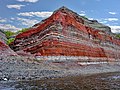 Image 5Layers of igneous rock from the Putorana Plateau. (from Siberian Traps)
 Image 6An Indigenous Siberian shaman at Kranoyarsk Regional Museum, Russia (from Indigenous peoples of Siberia)
 Image 7The Putorana Plateau is composed of Siberian Traps. (from Siberian Traps)
 Image 8Step-like geomorphology at the Putorana Plateau, which is a World Heritage Site. (from Siberian Traps)
 Image 10A 17th-century koch in a museum in Krasnoyarsk. Kochs were the earliest icebreakers and were widely used by Russian people in the Arctic and on Siberian rivers. (from History of Siberia)
 Image 12Selkup man


 Image 16Siberian Tatars
 Image 17Indigenous Siberian canoe at Krasnoyarsk Regional Museum, Russia (from Indigenous peoples of Siberia)

 Image 20Ethnographic map of the Soviet Union, 1970 (from History of Siberia)
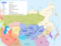 Image 22Siberia in 1636 (from History of Siberia)
 Image 23Indigenous Siberian musical instrument used with throat singing, at Krasnoyarsk Regional Museum, Russia (from Indigenous peoples of Siberia)
 Image 24Laminar armour from hardened leather reinforced by wood and bones such as this was worn by native Siberians (from Indigenous peoples of Siberia)
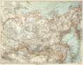 Image 251905 map of Siberia (from History of Siberia)
 Image 26Buryat shaman of Olkhon, Lake Baikal in eastern Siberia (from Indigenous peoples of Siberia)
 Image 27Lamellar armour traditionally worn by the Koryak people (c. 1900) (from Indigenous peoples of Siberia)
 Image 28Siberian peoples as depicted in the 17th century Remezov Chronicle. (from History of Siberia)
 Image 29The Khanate of Sibir in the 15th and 16th centuries (from History of Siberia)
 Image 30Ket woman
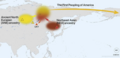 Image 31The map shows the origin of the first wave of humans into the Americas. Involved are the ANE (Ancestral Northern Eurasian, which represent a distinct Paleolithic Siberian population), and the NEA (Northeast Asians, which are an East Asian-related group). The admixture happened somewhere in Northeast Siberia. (from Indigenous peoples of Siberia)


_2_(17338266745).jpg)


_family.jpg)


_(Zeno_Fotografie).jpg)


.png)


Related portals
WikiProjects
Categories

Trans-Siberian Railway route map
| Trans–Siberian Railway | |||||||||||||||||||||||||||||||||||||||||||||||||||||||||||||||||||||||||||||||||||||||||||||||||||||||||||||||||||||||||||||||||||||||||||||||||||||||||||||||||||||||||||||||||||||||||||||||||||||||||||||||||||||||||||||||||||||||||||||||||||||||||||||||||||||||||||||||||||||||||||||||||||||||||||||||||||||||||||||||||||||||||||||||||||||||||||||||||||||||||||||||||||||||||||||||||||||||||||||||||||||||||||||||||||||||||||||||||||||||||||||||||||||||||||||||||||||||||||||||||||||||||||||||||||||||||||||||||||||||||||||||||||||||||||||||||||||||||||||||||||||||||||||||||||||||||||||||||||||||||||||||||||||||||||||||||||||||||||||||||||||||||||||||||||||||||||||||||||||||||||||||||||||||||||||||||||||||||||||||||||||||||||||||||||||||||||||||||||||||||||||||||||||||||||||||||||||||||||||||||||||||||||||||||||||||||||||||||||||||||||||||||||||||||||||||||||||||||||||||||||||||||||||||||||||||||||||||||||||||||||||||||||||||||||||||||||||||||||||||||||||||||||||||||||||||||||||||||||||||
| |||||||||||||||||||||||||||||||||||||||||||||||||||||||||||||||||||||||||||||||||||||||||||||||||||||||||||||||||||||||||||||||||||||||||||||||||||||||||||||||||||||||||||||||||||||||||||||||||||||||||||||||||||||||||||||||||||||||||||||||||||||||||||||||||||||||||||||||||||||||||||||||||||||||||||||||||||||||||||||||||||||||||||||||||||||||||||||||||||||||||||||||||||||||||||||||||||||||||||||||||||||||||||||||||||||||||||||||||||||||||||||||||||||||||||||||||||||||||||||||||||||||||||||||||||||||||||||||||||||||||||||||||||||||||||||||||||||||||||||||||||||||||||||||||||||||||||||||||||||||||||||||||||||||||||||||||||||||||||||||||||||||||||||||||||||||||||||||||||||||||||||||||||||||||||||||||||||||||||||||||||||||||||||||||||||||||||||||||||||||||||||||||||||||||||||||||||||||||||||||||||||||||||||||||||||||||||||||||||||||||||||||||||||||||||||||||||||||||||||||||||||||||||||||||||||||||||||||||||||||||||||||||||||||||||||||||||||||||||||||||||||||||||||||||||||||||||||||||||||||
External media

Most populated areas

Associated Wikimedia
The following Wikimedia Foundation sister projects provide more on this subject:
-
 Commons
Free media repository -
 Wikibooks
Free textbooks and manuals -
 Wikidata
Free knowledge base -
 Wikinews
Free-content news -
 Wikiquote
Collection of quotations -
 Wikisource
Free-content library -
 Wikiversity
Free learning tools -
 Wiktionary
Dictionary and thesaurus


