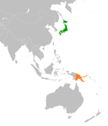
Portal:New Guinea
Wikipedia portal for content related to New Guinea / From Wikipedia, the free encyclopedia
Portal maintenance status: (April 2022)
|
Native name: Papua, Niugini, Niu Gini | |
|---|---|
 | |
| Geography | |
| Location | Oceania (Melanesia) |
| Archipelago | Melanesia and Malay Archipelago |
| Area | 785,753 km2 (303,381 sq mi) |
| Area rank | 2nd |
The New Guinea Portal
Introduction

New Guinea (Tok Pisin: Niugini; Hiri Motu: Niu Gini; Indonesian: Papua, fossilized Nugini, or historically Irian) is the world's second-largest island, with an area of 785,753 km2 (303,381 sq mi). Located in Melanesia in the southwestern Pacific Ocean, the island is separated from Australia by the 150-kilometre (81-nautical-mile; 93-mile) wide Torres Strait, though both landmasses lie on the same continental shelf, and were united during episodes of low sea level in the Pleistocene glaciations as the combined landmass of Sahul. Numerous smaller islands are located to the west and east. The island's name was given by Spanish explorer Yñigo Ortiz de Retez during his maritime expedition of 1545 due to the resemblance of the indigenous peoples of the island to those in the African region of Guinea. (Full article...)
Papua New Guinea, officially the Independent State of Papua New Guinea, is a country in Oceania that comprises the eastern half of the island of New Guinea and its offshore islands in Melanesia (a region of the southwestern Pacific Ocean north of Australia). It shares its only land border with Indonesia to the west and its other close neighbors are Australia to the south and the Solomon Islands to the east. Its capital, located on its southern coast, is Port Moresby. The country is the world's third largest island country, with an area of 462,840 km2 (178,700 sq mi). (Full article...)
Western New Guinea, also known as Papua, Indonesian New Guinea, and Indonesian Papua, is the western, formerly Dutch presently Indonesian, half of the island of New Guinea, granted to Indonesia in 1962. Given the island is alternatively named Papua, the region is also called West Papua (Indonesian: Papua Barat). (Full article...)
Selected article - load new batch
 Image 1
 Results by constituency
General elections were held in Papua New Guinea between 24 June and 8 July 2017. The writs for the election were issued on 20 April, and candidate nominations closed on 27 April.
Michael Somare, the first Prime Minister of Papua New Guinea, retired as a Member of National Parliament at the election. Somare has served continuously since he was first elected to the pre-independence House of Assembly in 1968, an unbroken term of 49 years.
On 1 August 2017 Peter O'Neill was re-elected as Prime Minister by Parliament by a vote of 64–40. (Full article...)- Image 2Papua New Guinea is home to several protected areas, which receive protection because of their environmental, cultural or similar value.
The total area of Papua New Guinea protected territories is 14,330 km2 (5,530 sq mi), which amounts to approximately 3.07% of the country's territory. The total number of protected areas as 2018 is 71.
The effort by the PNG government to protect biodiversity has resulted in 44 existing terrestrial protected areas using the International Union for the Conservation of Nature and Natural Resources (IUCN) categories. These protected areas account for 1.6% of the total land area. A study of biodiversity identified a further 398 areas as candidates for conservation. This would increase the total protected areas to 16.8% of the total country area. (Full article...) - Image 3

The Territory of New Guinea was an Australian-administered League of Nations and then United Nations trust territory on the island of New Guinea from 1914 until 1975. In 1949, the Territory and the Territory of Papua were established in an administrative union by the name of the Territory of Papua and New Guinea. That administrative union was renamed as Papua New Guinea in 1971. Notwithstanding that it was part of an administrative union, the Territory of New Guinea at all times retained a distinct legal status and identity until the advent of the Independent State of Papua New Guinea.
The initial Australian mandate, entitled the Mandate for the German Possessions in the Pacific Ocean situated South of the Equator other than German Samoa and Nauru, was based on the previous German New Guinea, which had been captured and occupied by Australian forces during World War I.
Most of the Territory of New Guinea was occupied by Japan during World War II, between 1942 and 1945. During this time, Rabaul, on the island of New Britain, became a major Japanese base (see New Guinea campaign). After World War II, the territories of Papua and New Guinea were combined in an administrative union under the Papua New Guinea Provisional Administration Act (1945–46). (Full article...) - Image 4
 Physical map of New Guinea
The Great Papuan Plateau is a karst plateau in the Southern Highlands, Hela and Western Provinces of Papua New Guinea. It is bordered the upper stretches of the Kikori River and the Strickland River on the east and west, respectively, and the Karius Range, the southern edge of the highlands, including Mount Sisa (2,650 m), to the north, and Mount Bosavi (2,507 m) to the south.
The eastern part of the plateau, east of the Sioa River, covers about 525 square miles (1,360 km2) and had a sparse population of 2,100 people (1966 government census), speaking at least five different languages. The dominant ethnic groups of this region are the Bosavi, Hawalisi, and Onabasulu. Further to the west are the Etoro, Bedamuni, and Sonia. In general, these groups practice swidden agriculture with exploitation of taro.
The Great Papuan Plateau has petroleum resources, and a pipeline from the plateau to Daru is under construction. (Full article...) - Image 5
 A view of Finschhafen, October 1943
The Battle of Finschhafen was part of the Huon Peninsula campaign in New Guinea during World War II and was fought between Australian and Japanese forces. The fighting took place between 22 September and 24 October 1943 following the landing at Scarlet Beach, which was followed by a two-pronged advance on Finschhafen as the Australian 20th Infantry Brigade advanced on the town from the north, while the 22nd Infantry Battalion drove from the south, having advanced from the landing beaches east of Lae. After the capture of Finschhafen, the Japanese forces in the area withdrew towards Sattelberg where they sought to hold the Australians before launching a counteroffensive, which subsequently threatened the landing beach. This attack was repelled by Australian and American forces, with heavy casualties being inflicted on the Japanese. In the aftermath, the Australians went on the offensive, capturing Sattelberg, and then advancing towards the Wareo plateau. (Full article...) - Image 6The COVID-19 pandemic in Papua New Guinea is part of the worldwide pandemic of coronavirus disease 2019 (COVID-19) caused by severe acute respiratory syndrome coronavirus 2 (SARS-CoV-2). The virus was confirmed to have reached Papua New Guinea on 20 March 2020. On 4 May 2020, Papua New Guinea was declared COVID-19 free. However, on 20 June, the government confirmed another case of COVID-19, meaning that the disease was present again within the country.
Until early 2021, the country managed to stave off a major COVID-19 outbreak, with only 1,275 cases reported at the end of February according to Johns Hopkins University. In March cases tripled, with Prime Minister James Marape speaking of "rampant community transmission". By early May, the number of hospitalizations in the capital Port Moresby stabilized, but delays in receiving test results from regional areas were a concern.
In mid May, as the reasons for the apparent easing of the pandemic situation remained uncertain, discrepancies between government figures and higher ones from the provinces led to concerns that hundreds of COVID-19 cases had been missed in the national tally.
As of March 2022 Papua New Guinea has a total of 41,533 cumulative cases and 639 deaths. , the country had a vaccination rate of 3.5%, one of the lowest in the world. (Full article...) - Image 7

The monarchy of Papua New Guinea is a system of government in which a hereditary monarch is the sovereign and head of state of Papua New Guinea. The current Papua New Guinean monarch and head of state, since 8 September 2022, is King Charles III. As sovereign, he is the personal embodiment of the Papua New Guinean Crown. Although the person of the sovereign is equally shared with 14 other independent countries within the Commonwealth of Nations, each country's monarchy is separate and legally distinct. As a result, the current monarch is officially titled King of Papua New Guinea and, in this capacity, he and other members of the royal family undertake public and private functions domestically and abroad as representatives of Papua New Guinea. However, the King is the only member of the royal family with any constitutional role.
All executive authority is vested in the monarch, and royal approval is required for letters patent and Orders in Council to have legal effect. But the authority for these acts stems from the country's populace, in which sovereignty is vested, and the monarch's direct participation in any of these areas of governance is limited. Most of the powers are exercised by the elected members of parliament, the ministers of the Crown generally drawn from amongst them, and the judges and justices of the peace. Other powers vested in the Crown, such as dismissal of a prime minister, are significant but are treated only as reserve powers and as an important security part of the role of the monarchy.
The Crown today primarily functions as a guarantor of continuous and stable governance and a nonpartisan safeguard against the abuse of power. While some powers are exercisable only by the sovereign, most of the monarch's operational and ceremonial duties are exercised by his representative, the governor-general of Papua New Guinea. (Full article...) - Image 8
Japanese settlement in the Territory of Papua and German New Guinea (in what now constitutes modern-day Papua New Guinea) dates back to the early 20th century when migrants from Japan established copra plantations and trading businesses in the islands, specifically Rabaul. The Japanese community remained small throughout the first half of the 20th century, although there were Japanese migrating in and out of New Guinea in different years from 1901 to 1945, it generally never exceeded more than 100 as a whole community. Some Japanese stayed for short terms and were replaced by newer emigrants from Japan, others stayed for longer periods depending on their roles. Most Japanese in Papua were businessmen and plantation managers, although a few became fishermen. As almost all the migrants were men, many of them married local Papuan wives and raised mixed-race Japanese-Papuan families while other Japanese men staying only for short periods also had sexual cohabitations with local Papuan women, but in most cases without marrying. Many of them did produce offspring but they were generally abandoned by their Japanese fathers (some of whom were already married with children in Japan) and raised by their single Papuan mothers or sent to the orphanage. These abandoned mixed-race children's were recorded as ethnic Papuans in the census as the ethnicity of their fathers was unknown.
During World War II, the Imperial Japanese Army invaded New Guinea with 350,000 troops and occupied most of its territory from January 1942 to August 1945. Some Papuan women including mixed-race Japanese-Papuan women were forced to become comfort women. Most Japanese in the unoccupied areas of New Guinea were deported to Australia where they were confined. The majority of them were repatriated to Japan after the war, although their mixed-race children were allowed to remain behind and assimilated with the local populace. Official estimates show 207 Japanese-Papuan mixed descendants. (Full article...) - Image 9
 Rabaul from the Vulcanology Observatory, with the old town to the left and the new town to the right
Rabaul (/rɑːˈbaʊl/) is a township in the East New Britain province of Papua New Guinea, on the island of New Britain. It lies about 600 kilometres to the east of the island of New Guinea. Rabaul was the provincial capital and most important settlement in the province until it was destroyed in 1994 by falling ash from a volcanic eruption in its harbor. During the eruption, ash was sent thousands of metres into the air, and the subsequent rain of ash caused 80% of the buildings in Rabaul to collapse. After the eruption the capital was moved to Kokopo, about 20 kilometres (12 mi) away. Rabaul is continually threatened by volcanic activity, because it is on the edge of the Rabaul caldera, a flooded caldera of a large pyroclastic shield.
Rabaul was planned and built around the harbour area known as Simpsonhafen (Simpson Harbour) during the German New Guinea administration, which controlled the region from 1884 and formally through 1919. Rabaul was selected as the capital of the German New Guinea administration in 1905, and the administrative offices were transferred there in 1910. Rabaul was captured by the British Empire during the early days of World War I. It became the capital of the Australian-mandated Territory of New Guinea until 1937, when it was first destroyed by a volcano. During World War II, it was captured by Japan in 1942 and became its main base of military and naval activity in the South Pacific. Settlements and military installations around the edge of the caldera are often collectively called Rabaul, although the old town of Rabaul was reduced to practical insignificance by the volcanic eruption in 1937.
As a tourist destination, Rabaul is popular for its volcanoes, scuba diving and for snorkelling sites, spectacular harbour and other scenery, World War II history, flora and fauna, and the cultural life of the Tolai people. Before the 1994 eruption, Rabaul was a popular commercial and recreational boating destination; fewer private small craft visit now, but 10 to 12 cruise ships visit Rabaul each year, including the Queen Elizabeth, carrying up to 2,000 passengers. Tourism is a major industry in Rabaul and East New Britain generally. (Full article...) - Image 10

The yellow-bellied sheath-tailed bat (Saccolaimus flaviventris), also known as the yellow-bellied sheathtail or yellow-bellied pouched bat, is a microbat species of the family Emballonuridae found extensively in Australia and less commonly in parts of Papua New Guinea.
Although found throughout most parts of Australia, very little is known about its ecology due to the small size, nocturnal activity, and general elusiveness of most microbat species, making them difficult to study. They are sometimes mistaken for the endangered and less widely distributed bare-rumped sheathtail bat where the two species occur sympatrically, as well as other similar Emballonuridae species, but upon inspection are quite distinct and easily identified.
At present, the yellow-bellied sheath-tailed bat is the only member of the Microchiroptera that has been positively identified as a carrier of Australian bat lyssavirus. (Full article...) - Image 11

Sorong is the largest city and the capital of the Indonesian province of Southwest Papua. The city is located on the western tip of the island of New Guinea with its only land borders being with Sorong Regency. It is the gateway to Indonesia's Raja Ampat Islands, species rich coral reef islands in an area considered the heart of the world's coral reef biodiversity. It also is the logistics hub for Indonesia's thriving eastern oil and gas frontier. Sorong experienced rapid growth during the decade from 2010, and further growth is anticipated as Sorong becomes linked by road to other frontier towns in Papua's Bird's Head Peninsula. The official estimate of population as at mid 2023 was 294,978 - comprising 154,543 males and 140,435 females. The suburban area of Sorong city contains tropical rainforest and mangrove forest that has increasingly become popular as ecotourism attractions especially for birdwatching or wildlife watching. (Full article...) - Image 12

German New Guinea (German: Deutsch-Neuguinea) consisted of the northeastern part of the island of New Guinea and several nearby island groups and was the first part of the German colonial empire. The mainland part of the territory, called Kaiser-Wilhelmsland, became a German protectorate in 1884. Other island groups were added subsequently. The Bismarck Archipelago (New Britain, New Ireland and several smaller islands), and the North Solomon Islands were declared a German protectorate in 1885. The Caroline Islands, Palau, and the Mariana Islands (except for Guam) were bought from Spain in 1899. German New Guinea annexed the formerly separate German Protectorate of Marshall Islands, which also included Nauru, in 1906. German Samoa, though part of the German colonial empire, was not part of German New Guinea.
Following the outbreak of the First World War in 1914, Kaiser-Wilhelmsland and nearby islands fell to Australian forces, while Japan occupied most of the remaining German possessions in the Pacific. The mainland part of German New Guinea (Kaiser-Wilhelmsland), the Bismarck Archipelago and the North Solomon Islands are now part of Papua New Guinea. The Northern Mariana Islands are an unincorporated territory of the United States. The Carolines (as the Federated States of Micronesia), the Marshall Islands, Nauru and Palau are independent countries.
The islands to the east of Kaiser-Wilhelmsland, on annexation, were renamed the Bismarck Archipelago (formerly the New Britannia Archipelago) and the two largest islands renamed Neupommern ('New Pomerania', today's New Britain) and Neumecklenburg ('New Mecklenburg', now New Ireland). Due to their accessibility by water, however, these outlying islands were, and have remained, the most economically viable part of the territory. (Full article...) - Image 13
 Satellite image of the Ok Tedi River
The Ok Tedi is a river in New Guinea. The Ok Tedi Mine is located near the headwaters of the river, which is sourced in the Star Mountains. It is the second largest tributary of the Fly River. Nearly the entirety of the river runs through the North Fly District of the Western Province of Papua New Guinea, but the river crosses the international boundary with Indonesia for less than one kilometre. The largest settlement of the Western Province, Tabubil is located near its banks. (Full article...) - Image 14
 Kiunga township from space
Kiunga is a port town on the Fly River in the Western Province of Papua New Guinea, just upstream from the D'Albertis Junction with the Ok Tedi River. It is the southernmost terminus of the Kiunga-Tabubil Highway. Local industry rests on a cornerstone of freight and haulage, particularly from the Ok Tedi Mine and provisioning for the much larger town of Tabubil. Natural rubber has been an emerging industry more recently, with a processing/manufacturing plant being built in town. (Full article...) - Image 15
Lesbian, gay, bisexual, and transgender (LGBT) people in Papua New Guinea face legal challenges not experienced by non-LGBT residents. Male same-sex sexual activity is illegal, punishable by up to 14 years' imprisonment. The law is rarely enforced, but arrests still do happen, having occurred in 2015 and 2022. There are no legal restrictions against lesbian sex in the country.
Attitudes towards LGBT people are greatly influenced by Christian churches, as a majority of Papua New Guineans are Christian. Historically, gay men had certain societal roles. They would take on traditional female roles such as cooking and would participate with women in traditional festivals. However, some tribes were observed to have practiced ritual homosexuality such as the Etoro people and the Sambia people.
A lot of the attitudes towards LBGT people are also influenced by Australia's early occupation of Papua New Guinea. The Australian criminal law, originally derived from the Queensland Criminal Code created during British colonization, was extended to Papua New Guinea. Despite the Australian states starting to decriminalize same-sex sexual activity in 1975, Papua New Guinea retained this provision due to gaining independence in the same year, resulting in the continued criminalization of such activity there. (Full article...)


.jpg)


.svg)


Did you know (auto-generated)

- ... that Australian official Jack Emanuel was awarded the George Cross in 1971 after being stabbed to death whilst trying to resolve a land dispute with the Tolai people of New Guinea?
- ... that until Rufina Peter and Kessy Sawang's election in August 2022, Papua New Guinea was one of only three countries without a woman in parliament?
- ... that Dorkas Tokoro-Hanasbey, the only female member of the New Guinea Council, arrived thirty minutes late to her inauguration ceremony?
- ... that Australiformis semoni is a parasite that infests marsupials in Australia and New Guinea and whose infestation could cause debilitating ulcerative granulomatous gastritis?
- ... that the clinical trials of British scientist Peter Pharoah helped eradicate congenital iodine deficiency syndrome (cretinism) in Papua New Guinea?
- ... that David Dexter, who wrote the New Guinea volume in the series Australia in the War of 1939–1945, was a commando who served in East Timor and New Guinea?
General images - show new batch
 Image 1An Australian soldier, Private George "Dick" Whittington, is aided by Papuan orderly Raphael Oimbari, near Buna on 25 December 1942. (from History of Papua New Guinea)
 Image 2Papuan lake dwellings with a lakatoi under sail, 1898 or before (from History of Papua New Guinea)
 Image 3Topographical map of New Guinea (from New Guinea)
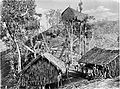
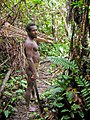
 Image 7New Guinea Volunteer Rifles with captured Japanese flag, 1942 (from History of Papua New Guinea)
 Image 8Regions of Oceania: Australasia, Polynesia, Micronesia, and Melanesia. Physiographically, Australasia includes the Australian landmass (including Tasmania), New Zealand, and New Guinea (from New Guinea)
 Image 9Group of natives at Mairy Pass. Mainland of British New Guinea in 1885. (from New Guinea)
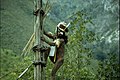 Image 10Yali Mabel, Kurulu Village War Chief at Baliem Valley (from New Guinea)
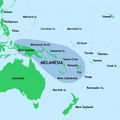
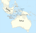 Image 12Map showing the combined landmass of Sahul formed during Pleistocene glacations (from New Guinea)
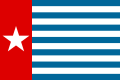 Image 13The Morning Star, flag of West Papua, was designed by the New Guinea Council in 1961. Its display is prohibited in some circumstances in Indonesia. (from History of Western New Guinea)
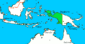
- Image 15The continent of Sahul before the rising ocean sundered Australia and New Guinea after the last ice age (from New Guinea)
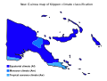 Image 16Papua New Guinea map of Köppen climate classification (from New Guinea)
 Image 18Papuans on the Lorentz River, photographed during the third South New Guinea expedition in 1912–13 (from New Guinea)

 Image 21Australian troops at Milne Bay, Papua.The Australian garrison was the first to inflict defeat on the Imperial Japanese Army during World War II at the Battle of Milne Bay of Aug–Sep 1942. (from History of Papua New Guinea)
 Image 23Flag under German control of New Guinea. (from History of Papua New Guinea)
 Image 24A 1644 map of New Guinea and the surrounding area (from New Guinea)

 Image 27British flag raised in Queensland 1883 (from History of Papua New Guinea)
 Image 28Political divisions of New Guinea (2006) (from New Guinea)
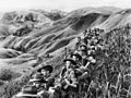 Image 29Australian soldiers resting in the Finisterre Ranges of New Guinea while en route to the front line (from New Guinea)
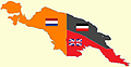 Image 30New Guinea from 1884 to 1919. The Netherlands controlled the western half of New Guinea, Germany the north-eastern part, and Britain the south-eastern part. (from New Guinea)
 Image 31A Japanese military map of New Guinea from 1943 (from New Guinea)
- Image 32A typical map from the Golden Age of Netherlandish cartography. Australasia during the Golden Age of Dutch exploration and discovery (ca. 1590s–1720s): including Nova Guinea (New Guinea), Nova Hollandia (mainland Australia), Van Diemen's Land (Tasmania), and Nova Zeelandia (New Zealand). (from History of Papua New Guinea)
- Image 33Regions of Oceania: Australasia, Polynesia, Micronesia, and Melanesia. Australasia include the Australian landmass (including Tasmania), New Zealand, and New Guinea. (from History of Papua New Guinea)
 Image 34Dutch expeditions in Netherlands New Guinea 1907–1915. (from History of Western New Guinea)
 Image 35Highlands of Papua New Guinea (from New Guinea)
 Image 36Map of New Guinea, with place names as used in English in the 1940s (from New Guinea)


.jpg)


.svg)


.png)


.jpg)


Related portals
In the news
- 27 May 2024 – 2024 Enga landslide
- Papua New Guinea asks for international help following the landslide in Enga Province three days ago, and reports that more than 2,000 people were buried alive and are now presumed deceased. (AP)
- 26 May 2024 – 2024 Enga landslide
- The International Organization for Migration estimates that more than 670 people were killed in the landslide in Enga Province, Papua New Guinea, on Friday. (AP)
- 24 May 2024 – 2024 Enga landslide
- Four people are confirmed killed and many others are presumed dead in a landslide in Enga Province, Papua New Guinea. (Papua New Guinea Post-Courier) (RNZ)
- 10 May 2024 – Palestine and the United Nations
- The United Nations General Assembly votes 143–9 with 25 abstentions to approve a resolution granting Palestine new rights and privileges, and to reconsider Palestine's request to become a UN member. The nine countries that opposed the resolution were Argentina, the Czech Republic, Hungary, Israel, Micronesia, Nauru, Palau, Papua New Guinea and the United States. (AP) (The National)
WikiProjects
General topics
Categories

Associated Wikimedia
The following Wikimedia Foundation sister projects provide more on this subject:
-
 Commons
Free media repository -
 Wikibooks
Free textbooks and manuals -
 Wikidata
Free knowledge base -
 Wikinews
Free-content news -
 Wikiquote
Collection of quotations -
 Wikisource
Free-content library -
 Wikiversity
Free learning tools -
 Wiktionary
Dictionary and thesaurus
External media


