
Leopoldshöhe
Municipality in North Rhine-Westphalia, Germany / From Wikipedia, the free encyclopedia
Leopoldshöhe is a municipality in the Lippe district of North Rhine-Westphalia, Germany, with ca. 16,000 inhabitants (2015).
Leopoldshöhe | |
|---|---|
 | |
 Coat of arms | |
Location of Leopoldshöhe within Lippe district 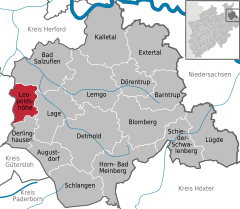 | |
 Leopoldshöhe  Leopoldshöhe | |
| Coordinates: 52°01′00″N 08°41′29″E | |
| Country | Germany |
| State | North Rhine-Westphalia |
| Admin. region | Detmold |
| District | Lippe |
| Government | |
| • Mayor (2020–25) | Martin Hoffmann[1] (SPD) |
| Area | |
| • Total | 36.93 km2 (14.26 sq mi) |
| Elevation | 113 m (371 ft) |
| Population (2022-12-31)[2] | |
| • Total | 16,614 |
| • Density | 450/km2 (1,200/sq mi) |
| Time zone | UTC+01:00 (CET) |
| • Summer (DST) | UTC+02:00 (CEST) |
| Postal codes | 33818 |
| Dialling codes | 05208, 05202, 05232, 05222 |
| Vehicle registration | LIP |
| Website | www.leopoldshoehe.de |
Located in the rolling plains north of the Teutoburger Wald range, Leopoldshöhe consists of eight formerly independent municipalities: Asemissen, Bechterdissen and Greste to the south, Leopoldshöhe proper, Krentrup and Schuckenbaum at the center, and Nienhagen and Bexterhagen to the north. Both Asemissen and Leopoldshöhe proper have a pronounced infrastructure (supermarkets, gas stations, specialized shops, etc.).
Located only 10 km from the city of Bielefeld, the southern and central parts of the municipality today have a mostly suburban feel to them, but also contain several industrial zones, whereas the north is still mainly rural.
Asemissen is only a few hundred meters away from the A2 autobahn motorway, and (with the Oerlinghausen railway station) is on the railway line from Bielefeld to Detmold and Lemgo. A bus service connects almost all villages to the railway station.