File:Wirral_peninsula_satellite.png
From Wikipedia, the free encyclopedia
No higher resolution available.
Wirral_peninsula_satellite.png (400 × 400 pixels, file size: 299 KB, MIME type: image/png)
| This is a file from the Wikimedia Commons. Information from its description page there is shown below. Commons is a freely licensed media file repository. You can help. |
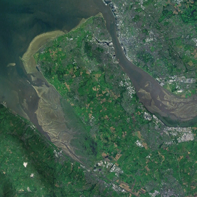
| DescriptionWirral peninsula satellite.png | A satellite photograph of the Wirral Peninsula (centre), showing the River Mersey and its estuary to the east, Liverpool Bay to the north and River Dee in the west across from the coast of Flintshire in Wales. |
| Date | |
| Source | NASA World Wind - Landsat 7 |
| Author | Smurrayinchester |
| Public domainPublic domainfalsefalse |
| This image is in the public domain because it is a screenshot from NASA’s globe software World Wind using a public domain layer, such as Blue Marble, MODIS, Landsat, SRTM, USGS or GLOBE.
العربيَّة | English | فارسی | français | עברית | македонски | മലയാളം | Nederlands | русский | 中文(中国大陆) | +/− |
 |
| Camera location | 53° 30′ 00″ N, 3° 23′ 24″ W | View this and other nearby images on: OpenStreetMap |
|---|
This file has been extracted from another file : Liverpool Bay.png |
 |
Captions
Add a one-line explanation of what this file represents
Items portrayed in this file
depicts
28 April 2007
53°30'0"N, 3°23'24"W
image/png
File history
Click on a date/time to view the file as it appeared at that time.
| Date/Time | Thumbnail | Dimensions | User | Comment | |
|---|---|---|---|---|---|
| current | 20:33, 29 August 2022 | | 400 × 400 (299 KB) | DankJae | File:Liverpool Bay.png cropped 69 % horizontally, 58 % vertically using CropTool with precise mode. |
File usage
The following pages on the English Wikipedia use this file (pages on other projects are not listed):
Global file usage
The following other wikis use this file:
- Usage on cy.wikipedia.org
Metadata
This file contains additional information, probably added from the digital camera or scanner used to create or digitize it.
If the file has been modified from its original state, some details may not fully reflect the modified file.
| File change date and time | 20:31, 29 August 2022 |
|---|
Retrieved from "https://en.wikipedia.org/wiki/File:Wirral_peninsula_satellite.png"