File:Tunis_Rapid_Transit_Map.png
From Wikipedia, the free encyclopedia
Size of this preview: 800 × 570 pixels. Other resolutions: 320 × 228 pixels | 640 × 456 pixels | 1,024 × 729 pixels | 1,280 × 912 pixels | 2,560 × 1,823 pixels | 4,403 × 3,136 pixels.
Original file (4,403 × 3,136 pixels, file size: 12.26 MB, MIME type: image/png)
| This is a file from the Wikimedia Commons. Information from its description page there is shown below. Commons is a freely licensed media file repository. You can help. |
Summary
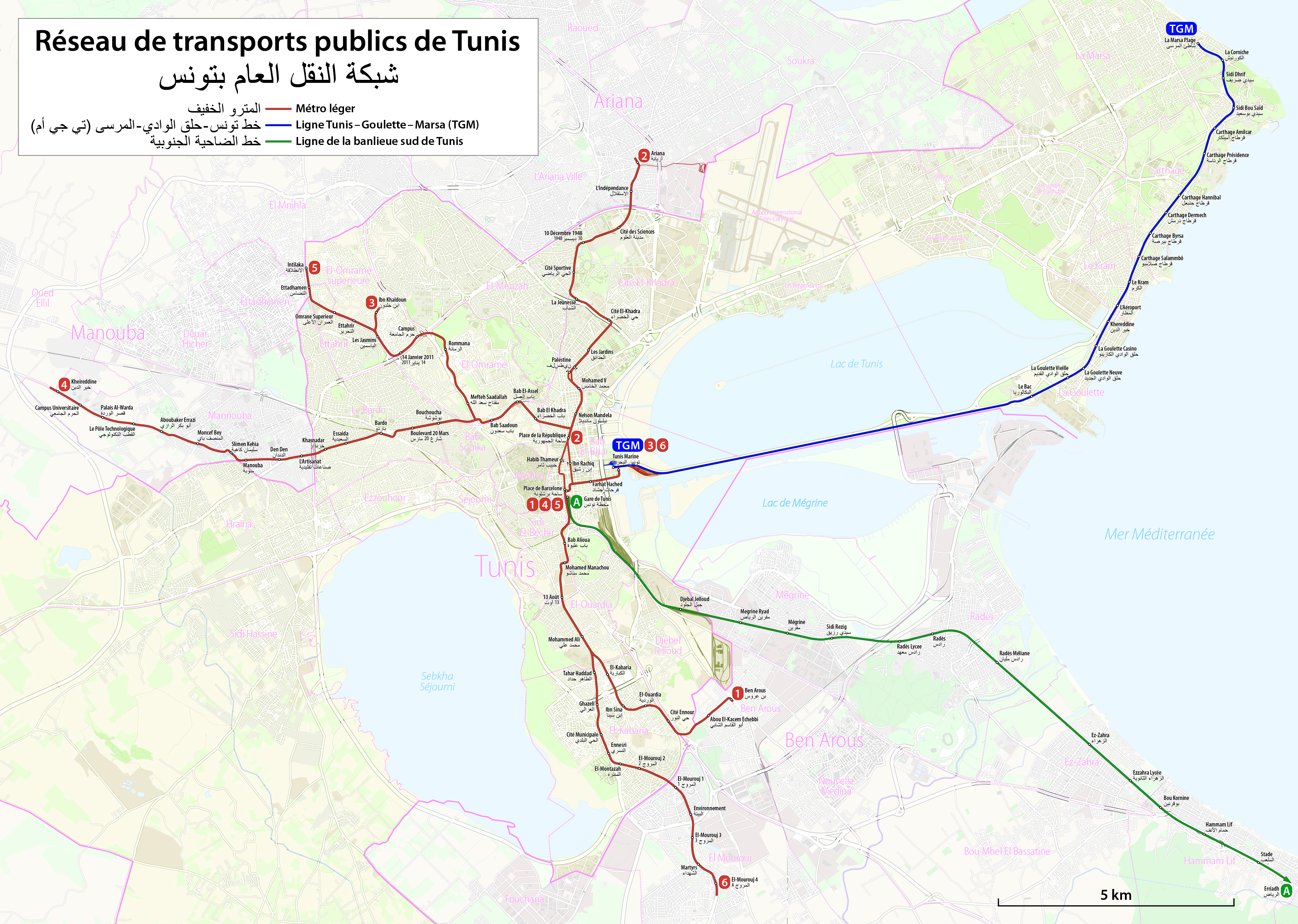
| DescriptionTunis Rapid Transit Map.png |
|
| Date | see file history |
| Source | Own work using: OpenStreetMap Data for the background |
| Author | Maximilian Dörrbecker (Chumwa) |
| Permission (Reusing this file) |
I, the copyright holder of this work, hereby publish it under the following license: This file is licensed under the Creative Commons Attribution-Share Alike 2.5 Generic license.
Sie dürfen das Bild zu den folgenden Bedingungen nutzen:
|
Captions
Add a one-line explanation of what this file represents
Items portrayed in this file
depicts
image/png
File history
Click on a date/time to view the file as it appeared at that time.
| Date/Time | Thumbnail | Dimensions | User | Comment | |
|---|---|---|---|---|---|
| current | 19:18, 12 June 2019 | | 4,403 × 3,136 (12.26 MB) | Chumwa | |
| 22:04, 11 June 2019 |  | 4,403 × 3,136 (12.26 MB) | Chumwa | ||
| 22:49, 10 June 2019 |  | 4,403 × 3,136 (12.25 MB) | Chumwa | ||
| 18:21, 10 June 2019 |  | 4,403 × 3,136 (12.09 MB) | Chumwa | ||
| 17:11, 10 June 2019 |  | 4,403 × 3,136 (12.1 MB) | Chumwa | ||
| 15:11, 10 June 2019 |  | 4,403 × 3,136 (12.13 MB) | Chumwa | == {{int:filedesc}} == {{Information |Description= *{{de|Schienennahverkehr in Tunis (Stadtbahn und Vorortzüge)}} *{{en|Tunis Rapid Transit Map (light rail and suburban trains)}} *{{fr|Réseau de transport public de Tunis (métro léger et RER)}} |Source={{own using}} OpenStreetMap Data for the background |Date=see file history |Author= Maximilian Dörrbecker (Chumwa) |Permission={{self|cc-by-sa-2.5}} Sie dürfen das Bild zu den folgenden Bedingungen nutzen... |
File usage
The following pages on the English Wikipedia use this file (pages on other projects are not listed):
Global file usage
The following other wikis use this file:
- Usage on ar.wikipedia.org
- Usage on ca.wikipedia.org
- Usage on de.wikipedia.org
- Usage on de.wikivoyage.org
- Usage on el.wikivoyage.org
- Usage on en.wikivoyage.org
- Usage on es.wikipedia.org
- Usage on fr.wikipedia.org
- Usage on fr.wikivoyage.org
- Usage on it.wikipedia.org
- Usage on it.wikivoyage.org
- Usage on ja.wikipedia.org
- Usage on nl.wikipedia.org
- Usage on pl.wikipedia.org
- Usage on pl.wikivoyage.org
- Usage on pt.wikipedia.org
- Usage on pt.wikivoyage.org
- Usage on ru.wikipedia.org
- Usage on th.wikipedia.org
- Usage on tr.wikipedia.org
- Usage on uk.wikipedia.org
- Usage on www.wikidata.org
- Usage on zh.wikipedia.org
Metadata
This file contains additional information, probably added from the digital camera or scanner used to create or digitize it.
If the file has been modified from its original state, some details may not fully reflect the modified file.
| Horizontal resolution | 37.8 dpc |
|---|---|
| Vertical resolution | 37.8 dpc |
| Software used |
Retrieved from "https://en.wikipedia.org/wiki/File:Tunis_Rapid_Transit_Map.png"