File:The_PEFO_Tepees.jpg
From Wikipedia, the free encyclopedia
Original file (4,288 × 2,536 pixels, file size: 7.73 MB, MIME type: image/jpeg)
| This is a file from the Wikimedia Commons. Information from its description page there is shown below. Commons is a freely licensed media file repository. You can help. |
| This is a featured picture, which means that members of the community have identified it as one of the finest images on the English Wikipedia, adding significantly to its accompanying article. If you have a different image of similar quality, be sure to upload it using the proper free license tag, add it to a relevant article, and nominate it. |
| This image was selected as picture of the day on the English Wikipedia for August 27, 2012. |
Summary
| DescriptionThe PEFO Tepees.jpg |
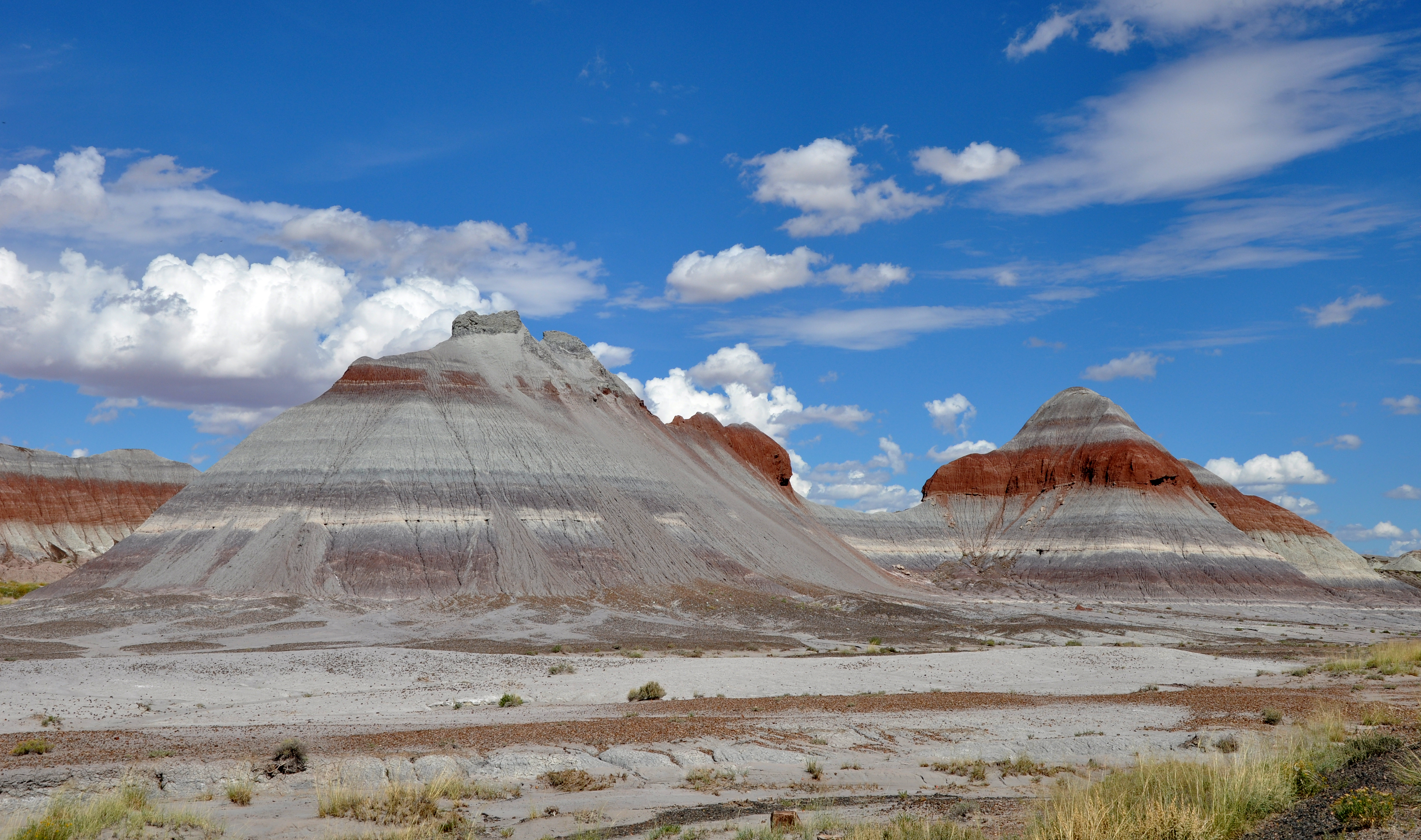
English: The Tepees in Petrified Forest National Park in northeastern Arizona, United States. View is toward the northwest from the main park road. According to a National Park Service (NPS) document, rock strata exposed in the Tepees area of the park belong to the Blue Mesa Member of the Chinle Formation and are about 220 to 225 million years old. The colorful bands of mudstone and sandstone were laid down during the Triassic, when the area was part of a huge tropical floodplain.
Français : Les Tepees (trad. « Tipis »), vus en regardant vers le nord-ouest depuis la route principale du Parc national de Petrified Forest, dans le nord-ouest de l'Arizona (États-Unis). Les roches exposées appartiennent à la formation de Chinle, datant du trias tardif (200-225 Ma). Ces bandes colorées de grès et de mudstone se sont formées lorsque la zone était une vaste plaine d'inondation. |
|||
| Date | ||||
| Source | Own work | |||
| Author | Finetooth | |||
| Other versions |
|
|

This image was selected as picture of the day on Wikimedia Commons for 8 March 2011. It was captioned as follows: English: The Tepees in Petrified Forest National Park in northeastern Arizona, United States. View is toward the northwest from the main park road. Other languages:
Čeština: Týpí v národním parku Petrified Fores (Zkamenělý les) v severovýchodní Arizoně v USA. Pohled směrem na severozápad od hlavní silnice v parku. Dansk: "The Tepees" i "Petrified Forest National Park" i det nordøstlige Arizona, USA. Set mod nordvest fra parkens hovedvej. Deutsch: Die Tepees in Petrified-Forest-Nationalpark im Nordosten Arizonas (USA) – Blick von der Hauptstraße Richtung Nordwesten English: The Tepees in Petrified Forest National Park in northeastern Arizona, United States. View is toward the northwest from the main park road. Español: Los Tepees en el Parque Nacional del Bosque Petrificado (noreste de Arizona, EE.UU.) Vista hacia el noroeste desde la carretera principal del parque. Italiano: Formazioni montuose, dette per la loro somiglianza con la tipica tenda indiana Teepee, nel Parco Nazionale della Foresta Pietrificata (Petrified Forest National Park) in Arizona. Magyar: Petrified Forest National Park (Arizona) Українська: «Вігвами» в національному парку Петріфайд Форест (Скам'янілий ліс), Аризона, США. Вид з головної дороги парку в північно-західному напрямку. Гірським породам ділянки «Вігвамів» приблизно 220 - 225 мільйонів років. Барвисті смуги аргілітів і пісковиків були закладені в Тріасі, коли територія була частиною величезної тропічної заплави. 日本語: 米国アリゾナ州西北部のペトリファイド・フォレスト国立公園にある山。ティピー(インディアンの小屋)と呼ばれている。 中文: 美国亚利桑纳州东北部石化林国家公园的土丘 |
Licensing
- You are free:
- to share – to copy, distribute and transmit the work
- to remix – to adapt the work
- Under the following conditions:
- attribution – You must give appropriate credit, provide a link to the license, and indicate if changes were made. You may do so in any reasonable manner, but not in any way that suggests the licensor endorses you or your use.
- share alike – If you remix, transform, or build upon the material, you must distribute your contributions under the same or compatible license as the original.

|
Permission is granted to copy, distribute and/or modify this document under the terms of the GNU Free Documentation License, Version 1.2 or any later version published by the Free Software Foundation; with no Invariant Sections, no Front-Cover Texts, and no Back-Cover Texts. A copy of the license is included in the section entitled GNU Free Documentation License.http://www.gnu.org/copyleft/fdl.htmlGFDLGNU Free Documentation Licensetruetrue |
This image has been assessed using the Quality image guidelines and is considered a Quality image.
العربية ∙ جازايرية ∙ беларуская ∙ беларуская (тарашкевіца) ∙ български ∙ বাংলা ∙ català ∙ čeština ∙ Cymraeg ∙ Deutsch ∙ Schweizer Hochdeutsch ∙ Zazaki ∙ Ελληνικά ∙ English ∙ Esperanto ∙ español ∙ eesti ∙ euskara ∙ فارسی ∙ suomi ∙ français ∙ galego ∙ עברית ∙ हिन्दी ∙ hrvatski ∙ magyar ∙ հայերեն ∙ Bahasa Indonesia ∙ italiano ∙ 日本語 ∙ Jawa ∙ ქართული ∙ 한국어 ∙ kurdî ∙ Lëtzebuergesch ∙ lietuvių ∙ македонски ∙ മലയാളം ∙ मराठी ∙ Bahasa Melayu ∙ Nederlands ∙ Norfuk / Pitkern ∙ polski ∙ português ∙ português do Brasil ∙ rumantsch ∙ română ∙ русский ∙ sicilianu ∙ slovenčina ∙ slovenščina ∙ shqip ∙ српски / srpski ∙ svenska ∙ தமிழ் ∙ తెలుగు ∙ ไทย ∙ Tagalog ∙ Türkçe ∙ toki pona ∙ українська ∙ vèneto ∙ Tiếng Việt ∙ 中文 ∙ 中文(简体) ∙ 中文(繁體) ∙ +/− |
Captions
Items portrayed in this file
depicts
4 October 2010
0.002 second
11
32 millimetre
200
image/jpeg
File history
Click on a date/time to view the file as it appeared at that time.
| Date/Time | Thumbnail | Dimensions | User | Comment | |
|---|---|---|---|---|---|
| current | 18:36, 31 October 2010 | | 4,288 × 2,536 (7.73 MB) | Finetooth | {{Information |Description={{en|1=The Tepees in Petrified Forest National Park in northeastern Arizona, United States. View is toward the northwest from the main park road.}} |Source={{own}} |Author=[ |
File usage
- Blue Mesa Member
- Geology of Arizona
- List of national parks of the United States
- Petrified Forest National Park
- Talk:Petrified Forest National Park
- User:Abyssal/Portal Prehistory of North America
- User:Abyssal/Prehistory of North America/Selected picture/3
- User:MattEditor02
- User:Nouill/sandbox
- User talk:Elekhh/Archive 2011
- User talk:Elekhh/Archive 2012
- User talk:Finetooth/Archive 11
- User talk:Finetooth/Archive 14
- Wikipedia:2012 main page redesign proposal/Nouill (alt. version of Pretzels design)
- Wikipedia:Featured picture candidates/January-2011
- Wikipedia:Featured picture candidates/Petrified Forest National Park
- Wikipedia:Featured pictures/Places/Landscapes
- Wikipedia:Featured pictures thumbs/26
- Wikipedia:Main Page history/2012 August 27
- Wikipedia:Main Page history/2012 June 22
- Wikipedia:Picture of the day/August 2012
- Wikipedia:Today's featured article/June 2012
- Wikipedia:Today's featured article/June 22, 2012
- Wikipedia:WikiProject Protected areas
- Wikipedia:WikiProject United States/Featured pictures
- Wikipedia:WikiProject United States/Quality content
- Wikipedia:WikiProject United States/Recognized content
- Wikipedia:Wikipedia Signpost/2010-11-22/Features and admins
- Wikipedia:Wikipedia Signpost/Single/2010-11-22
- Template:POTD/2012-08-27
- Category talk:Geography
- Portal:Arizona/Selected Article
- Portal:Arizona/Selected Article/7
- Portal:Geography/Featured article
- Portal:Geography/Featured article/17
- Portal:Paleontology/Selected picture
- Portal:Paleontology/Selected picture/22
Global file usage
The following other wikis use this file:
- Usage on ar.wikipedia.org
- Usage on ban.wikipedia.org
- Usage on be-tarask.wikipedia.org
- Usage on bn.wikipedia.org
- Usage on ca.wikipedia.org
- Usage on ceb.wikipedia.org
- Usage on crh.wikipedia.org
- Usage on cs.wikipedia.org
- Usage on cv.wikipedia.org
- Usage on cy.wikipedia.org
- Usage on da.wikipedia.org
- Usage on de.wikipedia.org
- Usage on el.wikipedia.org
- Usage on en.wikivoyage.org
- Usage on eo.wikipedia.org
- Usage on es.wikipedia.org
- Usage on et.wikipedia.org
- Usage on eu.wikipedia.org
- Usage on fa.wikipedia.org
- پارک ملی جنگل سنگی
- ویکیپدیا:نگارههای برگزیده/جاها/طبیعت
- ویکیپدیا:گزیدن نگاره برگزیده/سپتامبر-۲۰۱۲
- درگاه:جغرافیا/نگارهٔ برگزیده
- ویکیپدیا:نگارههای پیشنهادی/طبیعت
- بحث کاربر:Sunfyre/بایگانی ۵
- ویکیپدیا:گزیدن نگاره برگزیده/The PEFO Tepees.jpg
- ویکیپدیا:نگاره روز/آوریل ۲۰۱۳
- الگو:نر/2013-04-07
- الگو:نر محافظت شده/2013-04-07
- درگاه:جغرافیا/نگارهٔ برگزیده/۲۰
- درگاه:ایالات متحده آمریکا/نگاره برگزیده
- درگاه:ایالات متحده آمریکا/جغرافیا
- درگاه:ایالات متحده آمریکا/نگاره برگزیده/۴۰
- درگاه:ایالات متحده آمریکا/جغرافیا/۳
- Usage on fi.wikipedia.org
- Usage on fr.wikipedia.org
- Usage on fr.wikivoyage.org
- Usage on he.wikipedia.org
View more global usage of this file.
Metadata
This file contains additional information, probably added from the digital camera or scanner used to create or digitize it.
If the file has been modified from its original state, some details may not fully reflect the modified file.
| Camera manufacturer | NIKON CORPORATION |
|---|---|
| Camera model | NIKON D90 |
| Exposure time | 1/500 sec (0.002) |
| F-number | f/11 |
| ISO speed rating | 200 |
| Date and time of data generation | 10:43, 4 October 2010 |
| Lens focal length | 32 mm |
| Orientation | Normal |
| Horizontal resolution | 300 dpi |
| Vertical resolution | 300 dpi |
| Software used | Ver.1.00 |
| File change date and time | 10:43, 4 October 2010 |
| Y and C positioning | Co-sited |
| Exposure Program | Not defined |
| Exif version | 2.21 |
| Date and time of digitizing | 10:43, 4 October 2010 |
| Meaning of each component |
|
| Image compression mode | 4 |
| Exposure bias | 0 |
| Maximum land aperture | 4.1 APEX (f/4.14) |
| Metering mode | Pattern |
| Light source | Unknown |
| Flash | Flash did not fire, auto mode |
| DateTime subseconds | 00 |
| DateTimeOriginal subseconds | 00 |
| DateTimeDigitized subseconds | 00 |
| Supported Flashpix version | 1 |
| Color space | sRGB |
| Sensing method | One-chip color area sensor |
| File source | Digital still camera |
| Scene type | A directly photographed image |
| Custom image processing | Normal process |
| Exposure mode | Auto exposure |
| White balance | Auto white balance |
| Digital zoom ratio | 1 |
| Focal length in 35 mm film | 48 mm |
| Scene capture type | Standard |
| Scene control | None |
| Contrast | Normal |
| Saturation | Normal |
| Sharpness | Normal |
| Subject distance range | Unknown |
| GPS tag version | 2.2.0.0 |