File:Seismic-Map-of-India.png
From Wikipedia, the free encyclopedia
No higher resolution available.
Seismic-Map-of-India.png (483 × 512 pixels, file size: 192 KB, MIME type: image/png)
| This is a file from the Wikimedia Commons. Information from its description page there is shown below. Commons is a freely licensed media file repository. You can help. |
Summary
| DescriptionSeismic-Map-of-India.png |
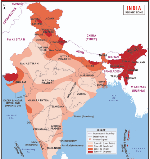
English: Seismic Zonation map of the country (state wise) given by Bureau of Indian Standards (BIS) has categorised into several seismic zones (Zone II to Zone V) |
| Date | |
| Source | https://www.moes.gov.in/ |
| Author | Ministry of Earth Science |
Licensing

|
This file is a copyrighted work of the Government of India, licensed under the Government Open Data License - India (GODL).
Information on Related Items:
https://data.gov.in/sites/default/files/Gazette_Notification_OGDL.pdf GODL-India Government Open Data License – India true true |
 |
|
Deutsch ∙ English ∙ español ∙ français ∙ हिन्दी ∙ 日本語 ∙ മലയാളം ∙ मराठी ∙ русский ∙ 中文(简体) ∙ 中文(繁體) ∙ 中文(臺灣) ∙ +/− |

|
This image, which was originally posted in the source indicated above, has not yet been reviewed by an administrator or reviewer to confirm that the above license is valid. See Category:Unreviewed photos of GODL-India for further instructions.
|
File history
Click on a date/time to view the file as it appeared at that time.
| Date/Time | Thumbnail | Dimensions | User | Comment | |
|---|---|---|---|---|---|
| current | 04:44, 4 November 2023 | | 483 × 512 (192 KB) | Curvasingh | Uploaded a work by Ministry of Earth Science from https://www.moes.gov.in/ with UploadWizard |
File usage
The following pages on the English Wikipedia use this file (pages on other projects are not listed):
Global file usage
The following other wikis use this file:
- Usage on bn.wikipedia.org
- Usage on es.wikipedia.org
- Usage on hi.wikipedia.org
- Usage on ml.wikipedia.org
- Usage on or.wikipedia.org
- Usage on ta.wikipedia.org
Retrieved from "https://en.wikipedia.org/wiki/File:Seismic-Map-of-India.png"