File:Relief_Yakutia.png
From Wikipedia, the free encyclopedia
Size of this preview: 647 × 599 pixels. Other resolutions: 259 × 240 pixels | 518 × 480 pixels | 923 × 855 pixels.
Original file (923 × 855 pixels, file size: 1.78 MB, MIME type: image/png)
| This is a file from the Wikimedia Commons. Information from its description page there is shown below. Commons is a freely licensed media file repository. You can help. |
Summary
| DescriptionRelief Yakutia.png |
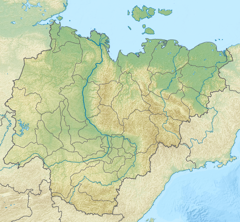
Русский: Физическая карта Якутии, Россия. |
| Date | |
| Source |
|
| Creator | |
| Geotemporal data | |
| Spatial reference system |
Русский: * Проекция: Коническая равнопромежуточная проекция, параметры проекции подобраны под File:Yakutia notext.svg
|
| Georeferencing | Georeference the map in Wikimaps Warper If inappropriate please set warp_status = skip to hide. |
Licensing
I, the copyright holder of this work, hereby publish it under the following license:
This file is licensed under the Creative Commons Attribution-Share Alike 3.0 Unported license.
- You are free:
- to share – to copy, distribute and transmit the work
- to remix – to adapt the work
- Under the following conditions:
- attribution – You must give appropriate credit, provide a link to the license, and indicate if changes were made. You may do so in any reasonable manner, but not in any way that suggests the licensor endorses you or your use.
- share alike – If you remix, transform, or build upon the material, you must distribute your contributions under the same or compatible license as the original.
Captions
Add a one-line explanation of what this file represents
Items portrayed in this file
depicts
File history
Click on a date/time to view the file as it appeared at that time.
| Date/Time | Thumbnail | Dimensions | User | Comment | |
|---|---|---|---|---|---|
| current | 18:55, 28 March 2013 | | 923 × 855 (1.78 MB) | Nzeemin | Water colors fixed |
| 10:22, 31 March 2012 |  | 923 × 855 (1.77 MB) | Nzeemin | removed thick border on coastline | |
| 19:34, 16 March 2012 |  | 923 × 855 (1.77 MB) | Nzeemin |
File usage
More than 100 pages use this file. The following list shows the first 100 pages that use this file only. A full list is available.
- Aby Lowland
- Alazeya
- Alazeya Plateau
- Aldan Highlands
- Aldan Shield
- Algama
- Allaikha
- Allakh-Yun (river)
- Ambarchik Bay
- Amedichi
- Amga (river)
- Anabar (river)
- Anabar Bay
- Baky
- Bappagay
- Batagaika crater
- Bolshaya Chukochya
- Bulkur
- Buor-Khaya Gulf
- Buotama
- Byoryolyokh
- Cape Svyatoy Nos (Laptev Sea)
- Chara (river)
- Chona
- Chondon
- Derba
- Derbeke
- Druzhina (river)
- Ebelyakh Bay
- Gonam
- Khroma
- Khroma Bay
- Kisilyakh Range
- Kolyma Bay
- Kolyma Gulf
- Kolyma Lowland
- Kular Range
- Labynkyr Lake
- Lake Bolshoye Toko
- Lake Bustakh
- Lake Khaiyr
- Lake Mogotoyevo
- Lake Nerpichye (Sakha Republic)
- Lake Ozhogino
- Linde (Lena)
- Lyutenge
- Malakatyn-Tas
- Markha (Lena)
- Markha (Vilyuy)
- Matta (river)
- Molodo (river)
- Moma Natural Park
- Moma Range
- Muna (Lena)
- Nedzheli
- Nera (Indigirka)
- Nordvik Bay
- Nyuya (river)
- Olenyok (river)
- Olyokma
- Omoloy
- Omulyakh Bay
- Omulyovka
- Orulgan Range
- Ozhogina
- Peak Pobeda (Sakha)
- Polousny Range
- Saltag-Tas
- Sededema
- Selennyakh (river)
- Selennyakh Range
- Sinyaya (Lena)
- Sundrun
- Suola (river)
- Suturuokha (lake)
- Suullar Myraan
- Tamma (river)
- Tatta
- Tiksi Bay
- Tuolba
- Uchur
- Ulakhan-Chistay Range
- Ulakhan-Sis Range
- Uyandina
- Vilyuy
- Yana-Indigirka Lowland
- Yana (river)
- Yana Bay
- Yasachnaya
- Yudoma
- Zyryanka (river)
- User:Fraenir/Draft4
- User:Ty654/List of earthquakes from 1910-1919 exceeding magnitude 6+
- User:Ty654/List of earthquakes from 1920-1929 exceeding magnitude 6+
- User:Ty654/List of earthquakes from 1950-1954 exceeding magnitude 6+
- User:Ty654/List of earthquakes from 1950-1999 exceeding magnitude 7+
- User:Ty654/List of earthquakes from 1960-1964 exceeding magnitude 6+
- User:Ty654/List of earthquakes from 1985-1989 exceeding magnitude 6+
- User:Ty654/List of earthquakes from 2005-2009 exceeding magnitude 6+
- User:Ty654/List of earthquakes from 2010-2014 exceeding magnitude 6+
View more links to this file.
Global file usage
The following other wikis use this file:
- Usage on arz.wikipedia.org
- Usage on az.wikipedia.org
- Şablon:Kömür yatağı
- Şablon:Kömür yatağı/doc
- Şablon:Yer xəritəsi Rusiya Yakutiya
- Şərqi Sibir dənizi
- Laptevlər dənizi
- Yeni Sibir
- Kotelnı (ada)
- Bennett adası
- Yaya (ada)
- Vasilevski adası
- Kolesovski
- Kolesovskaya Otmel
- Vilkiski adası
- Belkovski adası
- Stolbovoy (ada)
- Henriett adası
- Semyonovski adası
- Jeleznyakov adası
- Kotordır
- Matar
- Nanosnıy adası
- Skrıtıy adası
- Tas-Arı adası
- Posadnıy
- Diomid
- Lısov adası
- Andreyev adası
- Puşkaryov adası
- Joxov
- Krestovski adası
- Çetıryoxstolbovoy (ada)
- Makar adası
- Orto-Arı
- Daqdalax
- Yarok adası
- Böyük Beqiçev
- Kiçik Beqiçev
- Muostax adası
View more global usage of this file.
Metadata
This file contains additional information, probably added from the digital camera or scanner used to create or digitize it.
If the file has been modified from its original state, some details may not fully reflect the modified file.
| Horizontal resolution | 35.45 dpc |
|---|---|
| Vertical resolution | 35.45 dpc |
| Software used |
Retrieved from "https://en.wikipedia.org/wiki/File:Relief_Yakutia.png"