File:Relief_Map_of_Armenia.png
From Wikipedia, the free encyclopedia
Size of this preview: 585 × 599 pixels. Other resolutions: 234 × 240 pixels | 469 × 480 pixels | 1,000 × 1,024 pixels.
Original file (1,000 × 1,024 pixels, file size: 1.73 MB, MIME type: image/png)
| This is a file from the Wikimedia Commons. Information from its description page there is shown below. Commons is a freely licensed media file repository. You can help. |
Summary
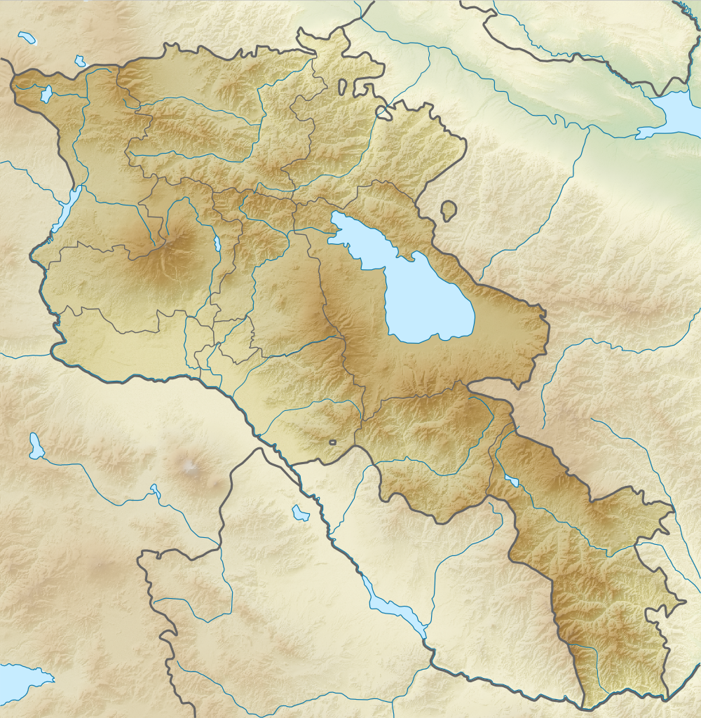
| DescriptionRelief Map of Armenia.png |
English: Relief map of Armenia. Equirectangular projection, N/S stretching 130 %. Geographic limits of the map:
Français : Carte topographique de l'Arménie. Projection cylindrique équidistante, avec étirement nord-sud de 130%.
|
| Date | |
| Source | |
| Author |
|
| Permission (Reusing this file) |
This file is licensed under the Creative Commons Attribution-Share Alike 3.0 Unported license.
|
Captions
Add a one-line explanation of what this file represents
Carte topographique de l'Arménie
Items portrayed in this file
depicts
26 August 2010
File history
Click on a date/time to view the file as it appeared at that time.
| Date/Time | Thumbnail | Dimensions | User | Comment | |
|---|---|---|---|---|---|
| current | 18:21, 22 February 2014 | | 1,000 × 1,024 (1.73 MB) | A2D2 | No unilateral changes. International borders are used. Please create additional svg map. |
| 09:21, 21 February 2014 |  | 585 × 599 (654 KB) | Հայկ Ափրիկյան | Added Artsakh. | |
| 19:49, 5 April 2012 |  | 1,000 × 1,024 (1.73 MB) | Sémhur | Adding few rivers : Dzoraget, Aghstafa, Azat, Vedi and Megri | |
| 19:36, 26 August 2010 |  | 1,000 × 1,024 (1.73 MB) | Виктор В | == {{int:filedesc}} == {{Information |Description={{en|Relief map of Armenia}} Equirectangular projection, N/S stretching 130 %. Geographic limits of the map: * N: 41.4° N * S: 38.8° N * W: 43.4° E * E: 46.7° E |Source=*[[:File:Armenia |
File usage
The following pages on the English Wikipedia use this file (pages on other projects are not listed):
- 1679 Armenia earthquake
- 1931 Zangezur earthquake
- 1988 Armenian earthquake
- 893 Dvin earthquake
- Aghjots Vank
- Akhtala Monastery
- Akhurian Reservoir
- Akhuryan (river)
- Ara (mountain)
- Aramazd mountains
- Areni-1 cave
- Areni Church
- Arevik National Park
- Azhdahak (volcano)
- Battle of Artaxata
- Battle of Garni
- Byurakan Observatory
- Dar-Alages
- Dilijan National Park
- Erebuni State Reserve
- Garni Temple
- Gazanaler
- Geghard
- Gladzor
- Godedzor
- Goshavank
- Haghartsin Monastery
- Haghpat Monastery
- Harichavank Monastery
- Hovhannavank
- Javakheti Range
- Kecharis Monastery
- Khosrov Forest State Reserve
- Khustup
- Kirants Monastery
- Kobayr monastery
- Lake Akna (Kotayk)
- Lake Arpi
- Lake Arpi National Park
- Lake Ayger
- Lake Kari
- Lake Lessing
- Lake Parz
- Lake Sev
- Lake Sevan
- List of fossiliferous stratigraphic units in Armenia
- Matosavank
- Meghri Dam
- Mordechai Navi Synagogue
- Mount Achkasar
- Mount Aragats
- Mount Kaputjugh
- Noravank
- Orgov Radio-Optical Telescope
- Porak
- Proshaberd
- Saghmosavank
- Sanahin Monastery
- Sevan National Park
- Sevanavank
- Shikahogh State Reserve
- St Gregory of Tigran Honents
- Tanahat Monastery
- Tandzut (river)
- Teishebaini
- Tejharuyk Monastery
- Tskhouk-Karckar
- Vanadzor (river)
- Vorotan (river)
- Yerevan
- Yerevan Lake
- User:Falcaorib
- User:Ty654/List of earthquakes from 1985-1989 exceeding magnitude 6+
- Module:Location map/data/Armenia
- Module:Location map/data/Armenia/doc
Global file usage
The following other wikis use this file:
- Usage on ar.wikipedia.org
- Usage on ast.wikipedia.org
- Usage on av.wikipedia.org
- Usage on azb.wikipedia.org
- Usage on az.wikipedia.org
- Ağçala dağı
- Göyçə gölü
- Şablon:Yer xəritəsi Ermənistan
- Zəngiçay
- Alagöz dağı
- Loru çökəkliyi
- Ləlvar dağı
- Qazangöl (Ermənistan)
- Şəki şəlaləsi
- Dilijan Milli Parkı
- Göyçə yarımadası
- Ardanış yarımadası
- Goravan səhrası
- Tej-əhməd dağı
- Kari gölü
- Arpi gölü
- Şikahoğ Dövlət Təbiət Qoruğu
- Erebuni Dövlət Təbiət Qoruğu
- Mehri SES
- Göyçə-Zəngi kaskadı
- İrəvan Dəmiryol Stansiyası
- Gümrü Dəmiryol Stansiyası
- Xosrov Dövlət Təbiət Qoruğu
- Göyçə Milli Parkı
- İrəvan Botanika Bağı
- Ağrı vadisi
- Şərqi Göyçə silsiləsi
- Nərədüz burnu
- Balıqlı (göl)
- Apaklu
- Qarnıyarıq dağı
- Bərgüşad kaskadı
- Bərgüşad silsiləsi
- Qılıncdağ
- Abaran (yaylaq)
- Ajdaak vulkanı
- Geğam silsiləsi
- Qanlı göl (Göyçə)
- Axuryan su anbarı
- Lecan dağı
- Gərni dərəsi
- İrəvan zəlzələsi (1679)
- Usage on ba.wikipedia.org
View more global usage of this file.
Metadata
This file contains additional information, probably added from the digital camera or scanner used to create or digitize it.
If the file has been modified from its original state, some details may not fully reflect the modified file.
| Horizontal resolution | 35.43 dpc |
|---|---|
| Vertical resolution | 35.43 dpc |
| Software used |
Retrieved from "https://en.wikipedia.org/wiki/File:Relief_Map_of_Armenia.png"