File:ReichskommissariatUkraineMap.png
From Wikipedia, the free encyclopedia
Size of this preview: 765 × 600 pixels. Other resolutions: 306 × 240 pixels | 612 × 480 pixels | 980 × 768 pixels | 1,280 × 1,004 pixels | 2,560 × 2,007 pixels | 3,000 × 2,352 pixels.
Original file (3,000 × 2,352 pixels, file size: 1.36 MB, MIME type: image/png)
| This is a file from the Wikimedia Commons. Information from its description page there is shown below. Commons is a freely licensed media file repository. You can help. |
Summary
| DescriptionReichskommissariatUkraineMap.png |
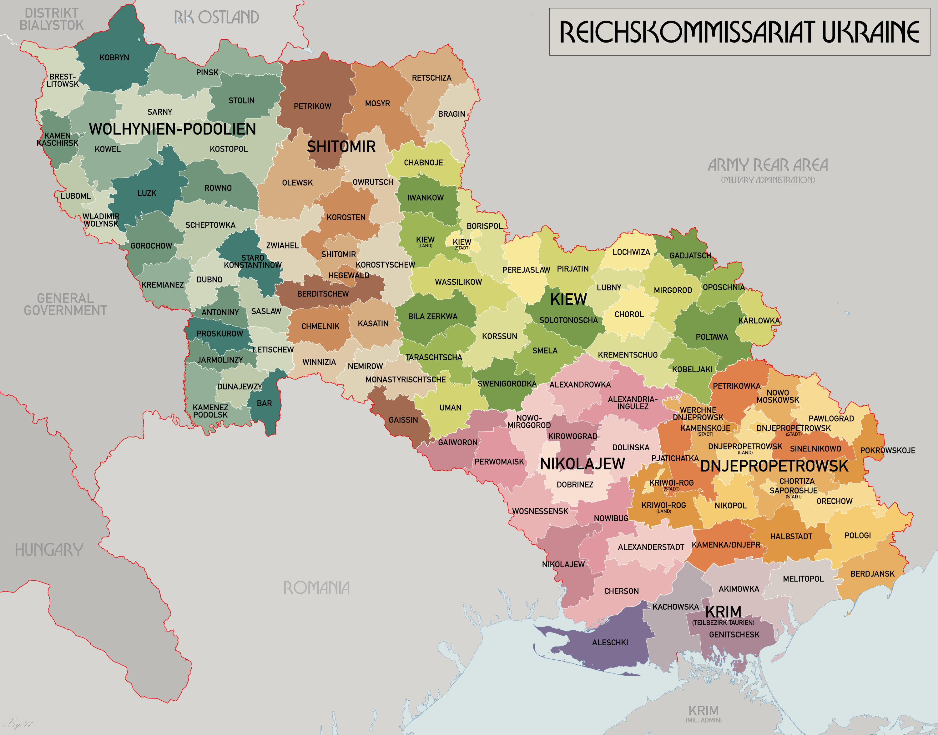
English: An administrative map of the Reichskommissariat Ukraine. Shows the boundaries of the Generalbezirke and Kreisgebiete as of September 1943. Source map data:
|
| Date | |
| Source | Own work |
| Author | XrysD |
| Other versions | Derivative works of this file: HegewaldColonyMap.png |
Licensing
I, the copyright holder of this work, hereby publish it under the following license:

|
Permission is granted to copy, distribute and/or modify this document under the terms of the GNU Free Documentation License, Version 1.2 or any later version published by the Free Software Foundation; with no Invariant Sections, no Front-Cover Texts, and no Back-Cover Texts. A copy of the license is included in the section entitled GNU Free Documentation License.http://www.gnu.org/copyleft/fdl.htmlGFDLGNU Free Documentation Licensetruetrue |
| This file is licensed under the Creative Commons Attribution-Share Alike 3.0 Unported license. | ||
| ||
| This licensing tag was added to this file as part of the GFDL licensing update.http://creativecommons.org/licenses/by-sa/3.0/CC BY-SA 3.0Creative Commons Attribution-Share Alike 3.0truetrue |
Captions
Add a one-line explanation of what this file represents
Items portrayed in this file
depicts
2008
File history
Click on a date/time to view the file as it appeared at that time.
| Date/Time | Thumbnail | Dimensions | User | Comment | |
|---|---|---|---|---|---|
| current | 09:25, 21 May 2017 | | 3,000 × 2,352 (1.36 MB) | XrysD | Reduced size and fixed edge issue. |
| 09:21, 21 May 2017 |  | 4,000 × 3,197 (1.95 MB) | XrysD | Completely new version. Source map data: [Verwaltungskarten Gebietes Ukraine 1:500k, US Library of Congress], [Karte des Deutschen Reiches (Grossblatter) 1:100k, Mapa Administracyjna Rzeczypospolitej Polska 1:300k, Karte von Mitteleuropa 1:300k, MapyWig] | |
| 16:39, 8 December 2015 |  | 1,803 × 1,060 (714 KB) | Artemco | • occupied territory under military administration, not directly Soviet Union • capital letters as Romania had • C → G | |
| 20:59, 16 May 2012 |  | 1,803 × 1,060 (708 KB) | XrysD | Added legend. Changed surrounding state names to common English versions. Changed colour set to Bartholomew version. | |
| 13:01, 22 July 2008 |  | 1,803 × 1,060 (205 KB) | XrysD | {{Information |Description={{en|1=An administrative map of the Reichskommissariat Ukraine. Shows the boundaries of the Generalbezirke and Kreisgebiete as of September 1943.}} |Source=Own work by uploader |Author=XrysD |Date=2008 |Permission |
File usage
The following pages on the English Wikipedia use this file (pages on other projects are not listed):
Global file usage
The following other wikis use this file:
- Usage on ar.wikipedia.org
- Usage on az.wikipedia.org
- Usage on be-tarask.wikipedia.org
- Usage on be.wikipedia.org
- Usage on bs.wikipedia.org
- Usage on ca.wikipedia.org
- Usage on cs.wikipedia.org
- Usage on da.wikipedia.org
- Usage on es.wikipedia.org
- Usage on fa.wikipedia.org
- Usage on fr.wikipedia.org
- Usage on he.wikipedia.org
- Usage on hr.wikipedia.org
- Usage on id.wikipedia.org
- Usage on it.wikipedia.org
- Usage on ja.wikipedia.org
- Usage on lt.wikipedia.org
- Usage on ms.wikipedia.org
- Usage on mt.wikipedia.org
- Usage on nl.wikipedia.org
- Usage on pl.wikipedia.org
- Usage on pt.wikipedia.org
- Usage on ro.wikipedia.org
- Usage on ru.wikipedia.org
- Usage on sh.wikipedia.org
- Usage on sr.wikipedia.org
- Usage on sv.wikipedia.org
- Usage on th.wikipedia.org
- Usage on uk.wikipedia.org
View more global usage of this file.
Metadata
This file contains additional information, probably added from the digital camera or scanner used to create or digitize it.
If the file has been modified from its original state, some details may not fully reflect the modified file.
| Horizontal resolution | 12.38 dpc |
|---|---|
| Vertical resolution | 12.38 dpc |
Retrieved from "https://en.wikipedia.org/wiki/File:ReichskommissariatUkraineMap.png"