File:Rangifer_tarandus_map.png
From Wikipedia, the free encyclopedia
Size of this preview: 800 × 397 pixels. Other resolutions: 320 × 159 pixels | 640 × 318 pixels | 1,024 × 508 pixels | 1,600 × 794 pixels.
Original file (1,600 × 794 pixels, file size: 107 KB, MIME type: image/png)
| This is a file from the Wikimedia Commons. Information from its description page there is shown below. Commons is a freely licensed media file repository. You can help. |
Summary
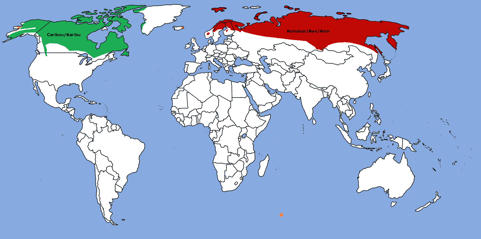
| DescriptionRangifer tarandus map.png |
Map: Distribution of Rangifer tarandus (Caribou/Reindeer)
|
| Date | |
| Source | Own work |
| Author | TBjornstad 11:46, 31 October 2006 (UTC) |
| Permission (Reusing this file) |
Public Domain |

|
This biogeographical map image could be re-created using vector graphics as an SVG file. This has several advantages; see Commons:Media for cleanup for more information. If an SVG form of this image is available, please upload it and afterwards replace this template with
{{vector version available|new image name}}.
It is recommended to name the SVG file “Rangifer tarandus map.svg”—then the template Vector version available (or Vva) does not need the new image name parameter. |
Licensing
| Public domainPublic domainfalsefalse |
| I, the copyright holder of this work, release this work into the public domain. This applies worldwide. In some countries this may not be legally possible; if so: I grant anyone the right to use this work for any purpose, without any conditions, unless such conditions are required by law. |
Captions
Add a one-line explanation of what this file represents
Items portrayed in this file
depicts
31 October 2006
File history
Click on a date/time to view the file as it appeared at that time.
| Date/Time | Thumbnail | Dimensions | User | Comment | |
|---|---|---|---|---|---|
| current | 13:39, 20 December 2019 | | 1,600 × 794 (107 KB) | Fenn-O-maniC | Fixed the southern border in Fennoscandia as according to https://www.suomenpeura.fi/en/wild-forest-reindeer/range.html (for forest reindeer, R. t. fennicus) and https://www.nordregio.org/maps/reindeer-herding-area/ (for mountain reindeer, R. t. tarandus, and its semi-domestic form) |
| 22:57, 8 July 2019 |  | 1,600 × 794 (106 KB) | Howpper | That part in southern Greenland should be green, because it was part of the larger green area, before I reduced it. | |
| 17:37, 8 May 2019 |  | 1,600 × 794 (126 KB) | Fährtenleser | Europäische Rentiere in Alaska (http://reindeerherding.org/herders/inupiaq-eskimo/) und Grönland (http://reindeerherding.org/herders/greenland/) hinzugefügt; Süd-Georgien wieder entfernt (lt. Artikel) | |
| 21:50, 17 August 2018 |  | 1,600 × 794 (63 KB) | Howpper | North America fixes. | |
| 20:07, 2 October 2014 |  | 1,600 × 794 (105 KB) | Fährtenleser | Svalbard and the other siberian islands added and scandinavien population corrected | |
| 15:30, 10 August 2012 |  | 1,600 × 794 (96 KB) | MPF | Range shown in Eurasia was too extensive; change introduced populations to orange | |
| 20:27, 23 January 2012 |  | 1,600 × 794 (95 KB) | Lemonade100 | Added population in east Iceland and the Highlands of Scotland, Great Britain | |
| 12:38, 15 March 2009 |  | 1,600 × 794 (47 KB) | Bogomolov.PL | added South Georgia | |
| 12:21, 15 March 2009 |  | 1,600 × 794 (47 KB) | Bogomolov.PL | Added en:Tuva and NW en:Mongolia | |
| 16:32, 17 December 2008 |  | 1,600 × 794 (216 KB) | Nesnad | ^o^ oops i was missing somethig apparently small population on an island here |
File usage
The following pages on the English Wikipedia use this file (pages on other projects are not listed):
Global file usage
The following other wikis use this file:
- Usage on af.wikipedia.org
- Usage on alt.wikipedia.org
- Usage on am.wikipedia.org
- Usage on ang.wikipedia.org
- Usage on ar.wikipedia.org
- Usage on arz.wikipedia.org
- Usage on ast.wikipedia.org
- Usage on avk.wikipedia.org
- Usage on be-tarask.wikipedia.org
- Usage on be.wikipedia.org
- Usage on bg.wikipedia.org
- Usage on bjn.wikipedia.org
- Usage on bn.wikipedia.org
- Usage on ca.wikipedia.org
- Usage on ceb.wikipedia.org
- Usage on cr.wikipedia.org
- Usage on cs.wikipedia.org
- Usage on cy.wikipedia.org
- Usage on da.wikipedia.org
- Usage on de.wikipedia.org
- Usage on el.wikipedia.org
- Usage on eo.wikipedia.org
- Usage on es.wikipedia.org
- Usage on eu.wikipedia.org
- Usage on fa.wikipedia.org
- Usage on fi.wikipedia.org
- Usage on fr.wikipedia.org
- Usage on ga.wikipedia.org
- Usage on gl.wikipedia.org
- Usage on hi.wikipedia.org
- Usage on hr.wikipedia.org
- Usage on hu.wikipedia.org
- Usage on id.wikipedia.org
- Usage on is.wikipedia.org
- Usage on ja.wikipedia.org
- Usage on kab.wikipedia.org
- Usage on ka.wikipedia.org
- Usage on kk.wikipedia.org
- Usage on kl.wikipedia.org
- Usage on ko.wikipedia.org
- Usage on ku.wikipedia.org
- Usage on lt.wikipedia.org
- Usage on lv.wikipedia.org
- Usage on ml.wikipedia.org
- Usage on mn.wikipedia.org
- Usage on ms.wikipedia.org
- Usage on my.wikipedia.org
View more global usage of this file.
Metadata
This file contains additional information, probably added from the digital camera or scanner used to create or digitize it.
If the file has been modified from its original state, some details may not fully reflect the modified file.
| Horizontal resolution | 37.79 dpc |
|---|---|
| Vertical resolution | 37.79 dpc |
Retrieved from "https://en.wikipedia.org/wiki/File:Rangifer_tarandus_map.png"