File:Prohibited_Area_P-40_Camp_David.png
From Wikipedia, the free encyclopedia
Size of this preview: 800 × 574 pixels. Other resolutions: 320 × 230 pixels | 640 × 459 pixels | 1,002 × 719 pixels.
Original file (1,002 × 719 pixels, file size: 408 KB, MIME type: image/png)
| This is a file from the Wikimedia Commons. Information from its description page there is shown below. Commons is a freely licensed media file repository. You can help. |
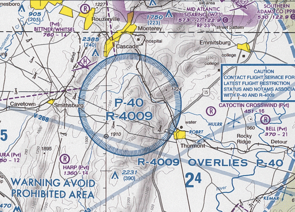
| DescriptionProhibited Area P-40 Camp David.png |
English: Section of VFR Terminal Area Raster Aeronautical Chart Baltimore/Washington, 84th edition, showing the prohibited area P-40 and restricted area R-4009 around Camp David Note: This map is valid until 26 July 2012. For navigational purposes, be sure to get the newest edition at the official FAA website |
| Date |
|
| Source | Baltimore-Washington_TAC_84.tif in Baltimore-Washington_TAC_84.zip. Note: The ZIP-File may become unavailable when the map is updated, newer editions will be available here |
| Author | US Department of Transportation, Federal Aviation Administration, National Aeronautical Navigation Services |
| Other versions |
| Public domainPublic domainfalsefalse |
This image or file is a work of a Federal Aviation Administration employee, taken or made as part of that person's official duties. As a work of the U.S. federal government, the image is in the public domain in the United States.
English | italiano | македонски | മലയാളം | Nederlands | русский | sicilianu | українська | 中文 | +/− |
 |
Captions
Add a one-line explanation of what this file represents
Items portrayed in this file
depicts
9 February 2012
File history
Click on a date/time to view the file as it appeared at that time.
| Date/Time | Thumbnail | Dimensions | User | Comment | |
|---|---|---|---|---|---|
| current | 15:34, 24 May 2012 | | 1,002 × 719 (408 KB) | El Grafo | update |
| 13:01, 27 April 2011 |  | 1,004 × 714 (353 KB) | El Grafo | {{Information |Description={{en|1=Section of VFR Terminal Area Raster Aeronautical Chart Baltimore/Washington, 82nd edition, showing the ''prohibited area'' P-40 and ''restricted area'' R-4009 around Camp David <small>Note: This map is |
File usage
The following pages on the English Wikipedia use this file (pages on other projects are not listed):
Global file usage
The following other wikis use this file:
- Usage on ar.wikipedia.org
- Usage on cs.wikipedia.org
- Usage on de.wikipedia.org
- Usage on es.wikipedia.org
- Usage on fa.wikipedia.org
- Usage on simple.wikipedia.org
- Usage on uk.wikipedia.org
- Usage on www.wikidata.org
Metadata
This file contains additional information, probably added from the digital camera or scanner used to create or digitize it.
If the file has been modified from its original state, some details may not fully reflect the modified file.
| Horizontal resolution | 28.35 dpc |
|---|---|
| Vertical resolution | 28.35 dpc |
| File change date and time | 15:00, 24 May 2012 |