File:Northern-Sentinel-Map.jpg
From Wikipedia, the free encyclopedia
Size of this preview: 628 × 600 pixels. Other resolutions: 251 × 240 pixels | 502 × 480 pixels | 804 × 768 pixels | 1,072 × 1,024 pixels | 2,144 × 2,048 pixels | 3,222 × 3,078 pixels.
Original file (3,222 × 3,078 pixels, file size: 5.3 MB, MIME type: image/jpeg)
| This is a file from the Wikimedia Commons. Information from its description page there is shown below. Commons is a freely licensed media file repository. You can help. |
Summary
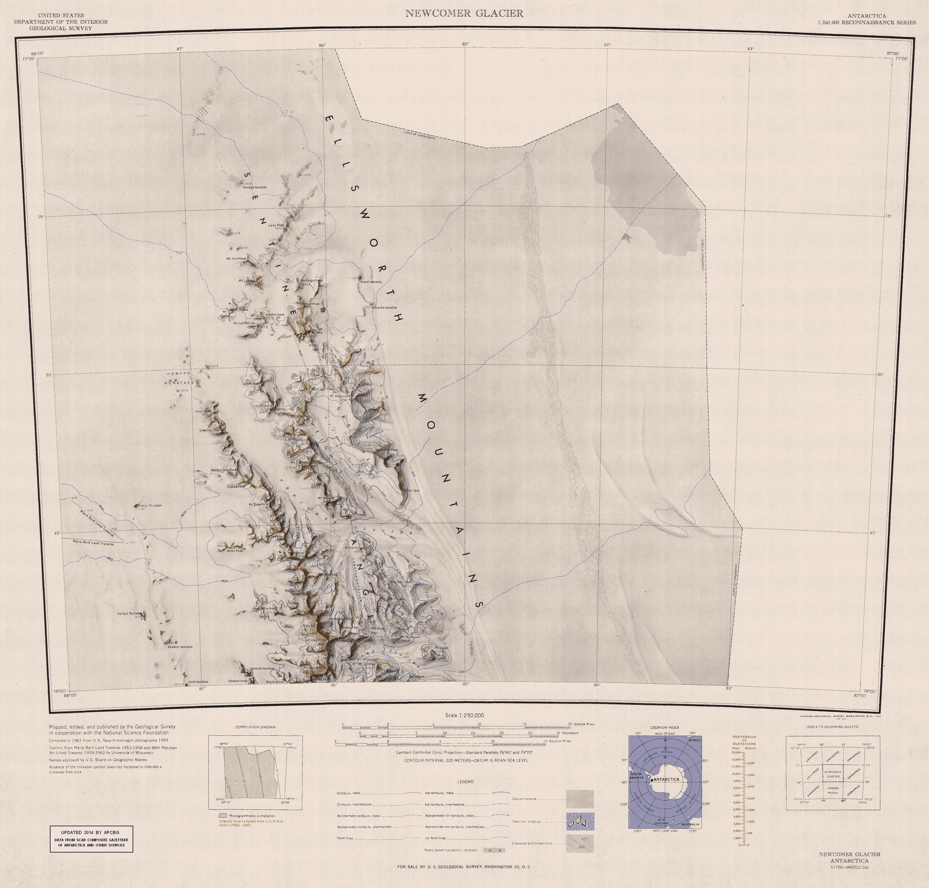
| DescriptionNorthern-Sentinel-Map.jpg |
English: Map of Northern Sentinel Range in Ellsworth Mountains, Antarctica |
| Date | |
| Source | https://usarc.usgs.gov/drgs/dir1/c77082s1.jpg |
| Author | United States Antarctic Resource Center of the US Geological Survey. |
| Other versions | Trimmed version of Wikimedia Commons File:C77082s1 Ant.Map Newcomer Glacier.jpg |
Licensing
| Public domainPublic domainfalsefalse |
This image is in the public domain in the United States because it only contains materials that originally came from the United States Geological Survey, an agency of the United States Department of the Interior. For more information, see the official USGS copyright policy.
Bahasa Indonesia ∙ català ∙ čeština ∙ Deutsch ∙ eesti ∙ English ∙ español ∙ français ∙ galego ∙ italiano ∙ Nederlands ∙ português ∙ polski ∙ sicilianu ∙ suomi ∙ Tiếng Việt ∙ Türkçe ∙ български ∙ македонски ∙ русский ∙ മലയാളം ∙ 한국어 ∙ 日本語 ∙ 中文 ∙ 中文(简体) ∙ 中文(繁體) ∙ العربية ∙ فارسی ∙ +/− |
Captions
Add a one-line explanation of what this file represents
Items portrayed in this file
depicts
1961
File history
Click on a date/time to view the file as it appeared at that time.
| Date/Time | Thumbnail | Dimensions | User | Comment | |
|---|---|---|---|---|---|
| current | 16:30, 22 January 2014 | | 3,222 × 3,078 (5.3 MB) | Apcbg | Updated with data from SCAR Composite Gazetteer of Antarctica and other sources. |
| 12:14, 20 November 2013 |  | 3,222 × 3,078 (5.22 MB) | Apcbg | User created page with UploadWizard |
File usage
The following pages on the English Wikipedia use this file (pages on other projects are not listed):
- Ahrida Peak
- Allen Peak
- Anchialus Glacier
- Arzos Peak
- Beadnos Nunatak
- Blenika Peak
- Bohot Nunatak
- Bracken Peak
- Branishte Peak
- Brocks Peak
- Duridanov Peak
- Ellsworth Mountains
- Fisher Nunatak
- Foros Spur
- Gromshin Heights
- Hariton Peak
- Helfert Nunatak
- Holth Peaks
- Howard Nunataks
- Kipra Gap
- Kovil Nunatak
- Lanz Peak
- MacDonald Peak
- Malasar Peak
- Matsch Ridge
- Memolli Nunatak
- Miller Bluffs
- Mount Alf
- Mount Barden
- Mount Cornwell (Antarctica)
- Mount Crawford (Antarctica)
- Mount Dalrymple
- Mount Dawson (Antarctica)
- Mount Goldthwait
- Mount Holmboe
- Mount Lanning
- Mount Liavaag
- Mount Lymburner
- Mount Malone
- Mount McKeown
- Mount Mogensen
- Mount Ojakangas
- Mount Reimer
- Mount Schmid
- Mount Sharp (Antarctica)
- Mount Tegge
- Mount Ulmer
- Mount Warren (Antarctica)
- Mount Weems
- Mount Wyatt Earp
- Mursalitsa Peak
- Nell Peak
- Newcomer Glacier
- Nikola Peak
- Olsen Peak
- Ostrusha Nunatak
- Pastrogor Peak
- Polarstar Peak
- Ravulya Nunatak
- Robinson Pass
- Rutford Ice Stream
- Sabazios Glacier
- Sentinel Range
- Shockey Peak
- Silyanov Peak
- Skafida Peak
- Skaklya Glacier
- Skamni Saddle
- Sostra Heights
- Vicha Glacier
- Vidul Glacier
- Vit Ice Piedmont
- Yamen Glacier
- Zhenda Glacier
Global file usage
The following other wikis use this file:
- Usage on ar.wikipedia.org
- Usage on az.wikipedia.org
- Usage on bg.wikipedia.org
- Usage on ceb.wikipedia.org
- Usage on de.wikipedia.org
- Usage on el.wikipedia.org
- Usage on es.wikipedia.org
- Usage on he.wikipedia.org
- Usage on it.wikipedia.org
- Usage on lld.wikipedia.org
- Usage on nn.wikipedia.org
- Usage on no.wikipedia.org
- Usage on tr.wikipedia.org
- Usage on uk.wikipedia.org
View more global usage of this file.
Retrieved from "https://en.wikipedia.org/wiki/File:Northern-Sentinel-Map.jpg"