File:New_Goethals_Bridge_from_airplane_cropped.jpg
From Wikipedia, the free encyclopedia
Original file (4,501 × 2,718 pixels, file size: 11.89 MB, MIME type: image/jpeg)
| This is a file from the Wikimedia Commons. Information from its description page there is shown below. Commons is a freely licensed media file repository. You can help. |
Summary
| DescriptionNew Goethals Bridge from airplane cropped.jpg |
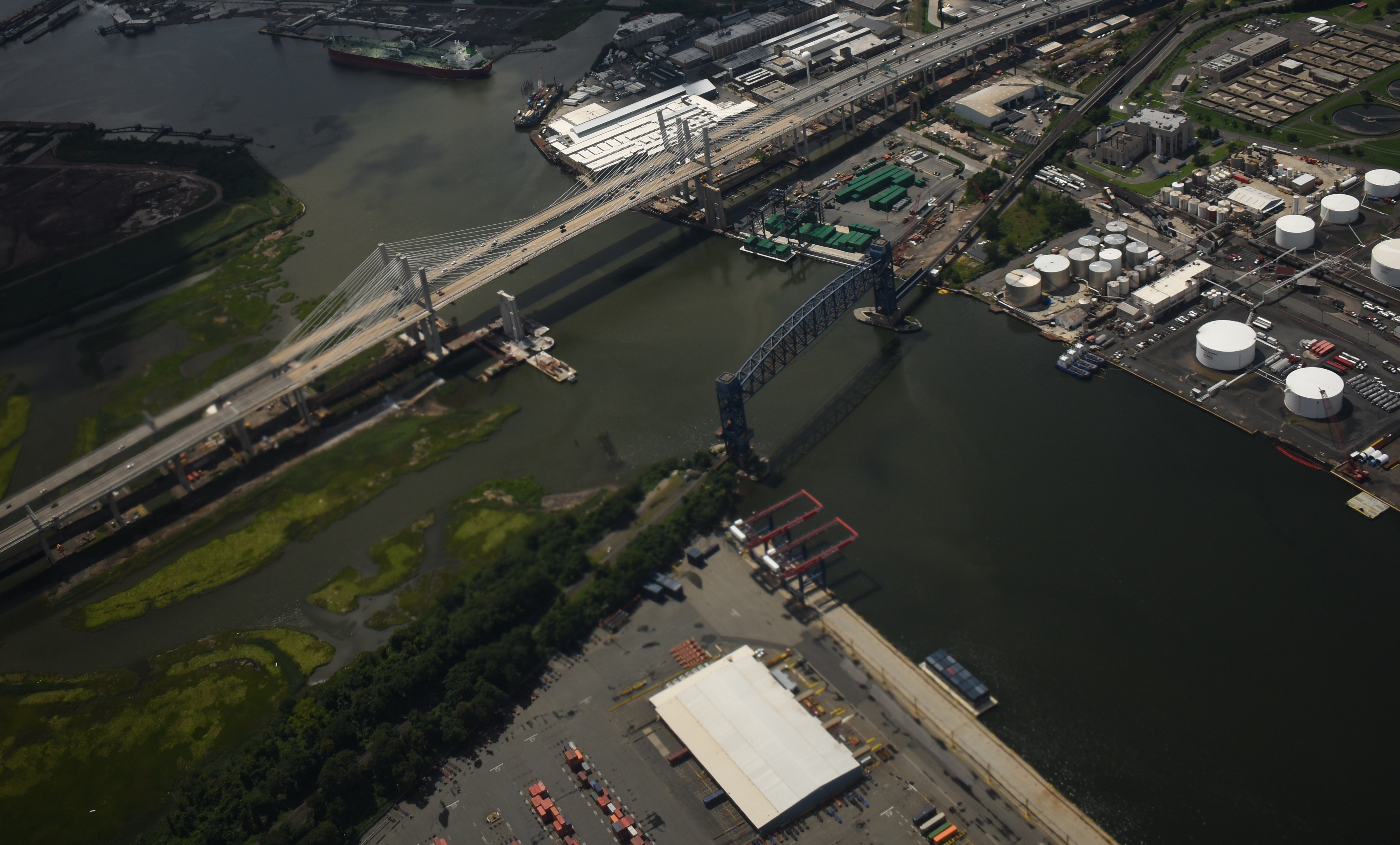
English: New w:Goethals Bridge over w:Arthur Kill between w:Staten Island, New York City and New Jersey in the USA. Supports for the old bridge are visible to the right of the new dual bridge. Also showen is the w:Arthur Kill Vertical Lift Bridge carrying a freight railroad track. The two barge-to-rail transfer facilities of New York City's new solid waste disposal system are also visible. One is on the New York Container Terminal on Staten Island, near the bottom, and is used by w:Covanta Energy; the other, on the New Jersey side between the Goethals Bridge and the Arthur Kill Vertical Lift Bridge, is used by w:Waste Management. Solid waste containers are on barges near both facilities. |
| Date | 4 August 2018, 14:06:50 |
| Source | File:New_Goethals_Bridge_from_airplane.jpg |
| Author | Siddharth Patil |
| Permission (Reusing this file) |
Cropping effort released under CC-0.--agr (talk) 15:44, 28 January 2019 (UTC) |
| Other versions | File:New_Goethals_Bridge_from_airplane.jpg |
| Camera location | 40° 38′ 07.69″ N, 74° 11′ 51.43″ W | View this and other nearby images on: OpenStreetMap |
|---|
Licensing
| This file is made available under the Creative Commons CC0 1.0 Universal Public Domain Dedication. | |
| The person who associated a work with this deed has dedicated the work to the public domain by waiving all of their rights to the work worldwide under copyright law, including all related and neighboring rights, to the extent allowed by law. You can copy, modify, distribute and perform the work, even for commercial purposes, all without asking permission.
http://creativecommons.org/publicdomain/zero/1.0/deed.enCC0Creative Commons Zero, Public Domain Dedicationfalsefalse |
| |||
| |||
Created by Siddharth Patil
Feel free to use my photo or file in any way you want. I would like it if you left me a note how you are using it on my talk page. Attribution isn't required, but it's always appreciated. |

Captions
Items portrayed in this file
depicts
40°38'7.69"N, 74°11'51.43"W
File history
Click on a date/time to view the file as it appeared at that time.
| Date/Time | Thumbnail | Dimensions | User | Comment | |
|---|---|---|---|---|---|
| current | 15:38, 28 January 2019 | | 4,501 × 2,718 (11.89 MB) | ArnoldReinhold | User created page with UploadWizard |
File usage
Global file usage
The following other wikis use this file:
- Usage on simple.wikipedia.org
- Usage on www.wikidata.org
Metadata
This file contains additional information, probably added from the digital camera or scanner used to create or digitize it.
If the file has been modified from its original state, some details may not fully reflect the modified file.
| Pixel composition | RGB |
|---|---|
| Orientation | Normal |
| Color space | sRGB |