File:National-atlas-minnesota.png
From Wikipedia, the free encyclopedia
Size of this preview: 776 × 600 pixels. Other resolutions: 311 × 240 pixels | 621 × 480 pixels | 994 × 768 pixels | 1,280 × 989 pixels | 2,560 × 1,978 pixels | 3,000 × 2,318 pixels.
Original file (3,000 × 2,318 pixels, file size: 1.41 MB, MIME type: image/png)
| This is a file from the Wikimedia Commons. Information from its description page there is shown below. Commons is a freely licensed media file repository. You can help. |
Summary
Transwiki approved by: w:en:User:Dmcdevit
This image was copied from wikipedia:en. The original description was:
Licensing
| Public domainPublic domainfalsefalse |
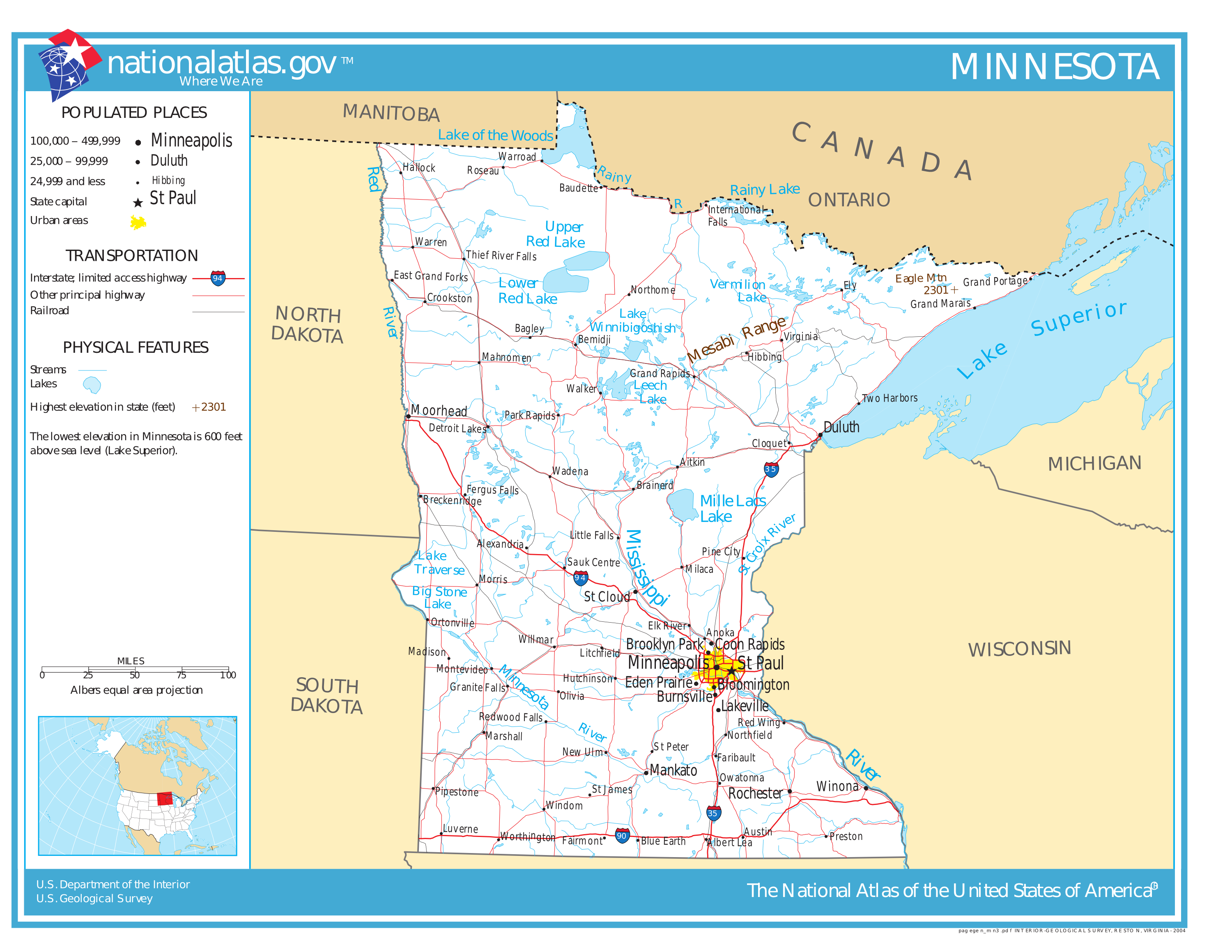
This map was obtained from an edition of the National Atlas of the United States. Like almost all works of the U.S. federal government, works from the National Atlas are in the public domain in the United States.
Online access: NationalAtlas.gov | 1970 print edition: Library of Congress, Perry-Castañeda Library čeština | Deutsch | English | français | Bahasa Indonesia | italiano | македонски | മലയാളം | sicilianu | 中文 | 中文(简体) | 中文(繁體) | +/− |
High quality SVG version of this located at: w:en::Image:National-atlas-minnesota.svg
Original upload log
| date/time | username | resolution | size | edit summary |
|---|---|---|---|---|
| 05:36, 20 September 2006 | w:en:User:Ravedave | 3000×2318 | 1.41 MB | |
| 05:31, 20 September 2006 | w:en:User:Ravedave | 3000×2318 | 1.4 MB | |
| 05:41, 2 August 2006 | w:en:User:Ravedave | 1530×1168 | 131 KB | |
| 11:40, 13 December 2004 | w:en:User:Berkut | 765×584 | 95 KB | reduced file size |
| 20:16, 4 November 2004 | w:en:User:Jengod | 765×584 | 252 KB | {{PD-USGov}} <a href="/wiki/Category:Minnesota_maps" title="Category:Minnesota maps">Category:Minnesota maps</a> |
Image description page history
Captions
Add a one-line explanation of what this file represents
Items portrayed in this file
depicts
image/png
File history
Click on a date/time to view the file as it appeared at that time.
| Date/Time | Thumbnail | Dimensions | User | Comment | |
|---|---|---|---|---|---|
| current | 16:02, 10 September 2007 | | 3,000 × 2,318 (1.41 MB) | BetacommandBot | Transwiki approved by: w:en:User:Dmcdevit This image was copied from wikipedia:en. The original description was: {{PD-USGov-Atlas}} w:en:Category:Minnesota maps High quality SVG version of this located at: [[w:en::Image:National-atlas-minnesot |
File usage
The following pages on the English Wikipedia use this file (pages on other projects are not listed):
Global file usage
The following other wikis use this file:
- Usage on et.wikipedia.org
- Usage on fo.wikipedia.org
- Usage on hr.wiktionary.org
- Usage on ja.wikipedia.org
- Usage on nl.wikipedia.org
- Usage on pam.wikipedia.org
- Usage on simple.wikipedia.org
- Usage on sr.wikipedia.org
- Usage on sv.wikipedia.org
- Usage on te.wikipedia.org
- Usage on tr.wikipedia.org
- Usage on uk.wikipedia.org
- Usage on vi.wikipedia.org
Retrieved from "https://en.wikipedia.org/wiki/File:National-atlas-minnesota.png"