File:Miami_neighborhoodsmap.png
From Wikipedia, the free encyclopedia
Size of this preview: 775 × 600 pixels. Other resolutions: 310 × 240 pixels | 620 × 480 pixels | 993 × 768 pixels | 1,280 × 990 pixels | 2,560 × 1,981 pixels | 4,063 × 3,144 pixels.
Original file (4,063 × 3,144 pixels, file size: 869 KB, MIME type: image/png)
| This is a file from the Wikimedia Commons. Information from its description page there is shown below. Commons is a freely licensed media file repository. You can help. |
Summary
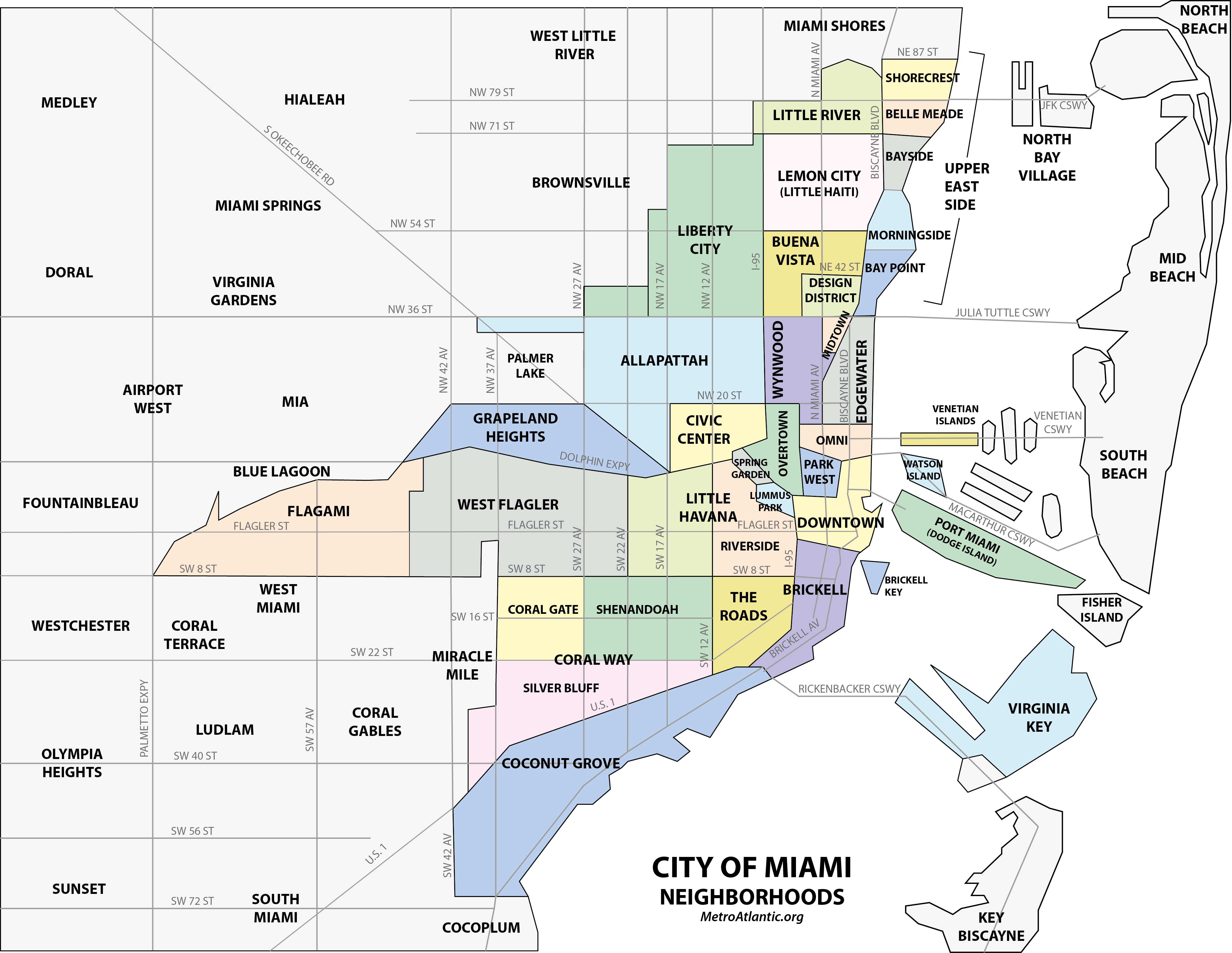
| DescriptionMiami neighborhoodsmap.png |
Map of the neighborhoods of the City of Miami, Florida, United States[1][2][3][4][5][6][7][8][9] References
|
| Date | (UTC) |
| Source | I created this work using various maps and images. |
| Author | Comayagua99 (talk) |
Licensing
Comayagua99 at English Wikipedia, the copyright holder of this work, hereby publishes it under the following licenses:
This file is licensed under the Creative Commons Attribution-Share Alike 3.0 Unported license.
Attribution: Comayagua99 at English Wikipedia
- You are free:
- to share – to copy, distribute and transmit the work
- to remix – to adapt the work
- Under the following conditions:
- attribution – You must give appropriate credit, provide a link to the license, and indicate if changes were made. You may do so in any reasonable manner, but not in any way that suggests the licensor endorses you or your use.
- share alike – If you remix, transform, or build upon the material, you must distribute your contributions under the same or compatible license as the original.

|
Permission is granted to copy, distribute and/or modify this document under the terms of the GNU Free Documentation License, Version 1.2 or any later version published by the Free Software Foundation; with no Invariant Sections, no Front-Cover Texts, and no Back-Cover Texts. A copy of the license is included in the section entitled GNU Free Documentation License.http://www.gnu.org/copyleft/fdl.htmlGFDLGNU Free Documentation Licensetruetrue |
You may select the license of your choice.
Original upload log
The original description page was here. All following user names refer to en.wikipedia.
- 2010-04-03 05:06 Comayagua99 3146×2796 (295637 bytes) {{Information |Description = |Source = I (~~~) created this work entirely by myself. |Date = ~~~~~ |Author = ~~~ |other_versions = }}
- 2010-04-03 15:41 Comayagua99 4121×3156 (594916 bytes)
- 2010-04-03 15:43 Comayagua99 4121×3156 (594916 bytes)
- 2010-04-03 15:43 Comayagua99 4121×3156 (594916 bytes)
- 2010-04-03 15:43 Comayagua99 3146×2796 (295637 bytes) Reverted to version as of 05:06, 3 April 2010
- 2010-04-03 15:46 Comayagua99 3121×2390 (967585 bytes)
- 2010-04-09 18:57 Comayagua99 4133×3158 (614086 bytes)
- 2010-04-09 18:59 Comayagua99 4133×3158 (614086 bytes)
- 2010-04-09 19:00 Comayagua99 2133×1630 (704462 bytes)
- 2011-03-27 18:34 Comayagua99 4064×3144 (616000 bytes)
- 2011-03-27 18:36 Comayagua99 977×755 (129889 bytes)
- 2011-03-27 18:37 Comayagua99 2032×1572 (278422 bytes)
- 2011-05-03 16:52 Comayagua99 2032×1572 (283481 bytes)
- 2011-05-13 02:48 Comayagua99 2032×1572 (353545 bytes)
- 2011-05-13 03:14 Comayagua99 2032×1572 (356040 bytes)
- 2011-05-13 03:57 Comayagua99 2032×1572 (355340 bytes)
- 2012-02-11 19:55 Comayagua99 4063×3144 (860264 bytes)
- 2012-02-11 20:20 Comayagua99 2031×1572 (391657 bytes)
Captions
Add a one-line explanation of what this file represents
Items portrayed in this file
depicts
File history
Click on a date/time to view the file as it appeared at that time.
| Date/Time | Thumbnail | Dimensions | User | Comment | |
|---|---|---|---|---|---|
| current | 22:31, 1 January 2013 | | 4,063 × 3,144 (869 KB) | McZusatz | Made minor revision to improve legibility of streets, neighborhood boundaries and other minor edits to improve accuracy of map. (--Comayagua99) |
| 03:56, 7 December 2012 |  | 2,031 × 1,572 (382 KB) | OgreBot | (BOT): Reverting to most recent version before archival | |
| 03:56, 7 December 2012 |  | 4,063 × 3,144 (840 KB) | OgreBot | (BOT): Uploading old version of file from en.wikipedia; originally uploaded on 2012-02-11 19:55:52 by Comayagua99 | |
| 03:56, 7 December 2012 |  | 2,032 × 1,572 (347 KB) | OgreBot | (BOT): Uploading old version of file from en.wikipedia; originally uploaded on 2011-05-13 03:57:49 by Comayagua99 | |
| 03:56, 7 December 2012 |  | 2,032 × 1,572 (348 KB) | OgreBot | (BOT): Uploading old version of file from en.wikipedia; originally uploaded on 2011-05-13 03:14:14 by Comayagua99 | |
| 03:56, 7 December 2012 |  | 2,032 × 1,572 (345 KB) | OgreBot | (BOT): Uploading old version of file from en.wikipedia; originally uploaded on 2011-05-13 02:48:29 by Comayagua99 | |
| 03:56, 7 December 2012 |  | 2,032 × 1,572 (277 KB) | OgreBot | (BOT): Uploading old version of file from en.wikipedia; originally uploaded on 2011-05-03 16:52:56 by Comayagua99 | |
| 03:56, 7 December 2012 |  | 2,032 × 1,572 (272 KB) | OgreBot | (BOT): Uploading old version of file from en.wikipedia; originally uploaded on 2011-03-27 18:37:30 by Comayagua99 | |
| 03:56, 7 December 2012 |  | 977 × 755 (127 KB) | OgreBot | (BOT): Uploading old version of file from en.wikipedia; originally uploaded on 2011-03-27 18:36:05 by Comayagua99 | |
| 03:56, 7 December 2012 |  | 4,064 × 3,144 (602 KB) | OgreBot | (BOT): Uploading old version of file from en.wikipedia; originally uploaded on 2011-03-27 18:34:08 by Comayagua99 |
File usage
The following pages on the English Wikipedia use this file (pages on other projects are not listed):
- Allapattah
- Arts & Entertainment District
- Brickell
- Brickell Key
- Buena Vista (Miami)
- Central Business District (Miami)
- Coconut Grove
- Edgewater (Miami)
- Flagami
- Grapeland Heights
- Greater Downtown Miami
- Grove Isle
- Health District (Miami)
- Liberty City (Miami)
- List of neighborhoods in Miami
- Little Haiti
- Little Havana
- Lummus Park Historic District
- Miami
- Midtown Miami
- Overtown (Miami)
- Park West (Miami)
- Riverside (Miami)
- Spring Garden (Miami)
- The Roads
- Upper Eastside
- Venetian Islands, Florida
- Virginia Key
- Watson Island
- West Flagler
- Wynwood
- User talk:Comayagua99/Archive 1
Global file usage
The following other wikis use this file:
- Usage on azb.wikipedia.org
- Usage on ca.wikipedia.org
- Usage on de.wikipedia.org
- Usage on es.wikipedia.org
- Usage on fa.wikipedia.org
- Usage on fr.wikipedia.org
- Usage on hi.wikipedia.org
- Usage on it.wikipedia.org
View more global usage of this file.
Metadata
This file contains additional information, probably added from the digital camera or scanner used to create or digitize it.
If the file has been modified from its original state, some details may not fully reflect the modified file.
| Horizontal resolution | 118.11 dpc |
|---|---|
| Vertical resolution | 118.11 dpc |
| Software used |
Retrieved from "https://en.wikipedia.org/wiki/File:Miami_neighborhoodsmap.png"