File:Macon_Bibb_Consolidated_Outline.png
From Wikipedia, the free encyclopedia
No higher resolution available.
Macon_Bibb_Consolidated_Outline.png (250 × 183 pixels, file size: 36 KB, MIME type: image/png)
| This is a file from the Wikimedia Commons. Information from its description page there is shown below. Commons is a freely licensed media file repository. You can help. |


- Other information
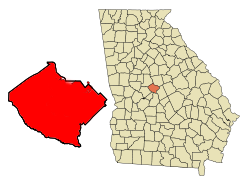
English: Logo updated to reflect new Macon city boundaries, as of July 31, 2012 consolidation referendum.
| Public domainPublic domainfalsefalse |
| This work has been released into the public domain by its author, Wikimedia Commons. This applies worldwide. In some countries this may not be legally possible; if so: Wikimedia Commons grants anyone the right to use this work for any purpose, without any conditions, unless such conditions are required by law. Public domainPublic domainfalsefalse |
Captions
Add a one-line explanation of what this file represents
Items portrayed in this file
depicts
image/png
File history
Click on a date/time to view the file as it appeared at that time.
| Date/Time | Thumbnail | Dimensions | User | Comment | |
|---|---|---|---|---|---|
| current | 17:46, 5 August 2012 | | 250 × 183 (36 KB) | Carlvlewis | {{subst:Upload marker added by en.wp UW}} {{Information |Description = {{en|The geographic outline of the newly consolidated Macon-Bibb County, Ga.}} |Source = Wikimedia Commons |Author = Wikimedia Commons |Permission = http://en.wikipedia.org/wiki/Fil... |
File usage
No pages on the English Wikipedia use this file (pages on other projects are not listed).
Global file usage
The following other wikis use this file:
- Usage on bn.wikipedia.org
- Usage on io.wikipedia.org
- Usage on nl.wikipedia.org
- Usage on tr.wikipedia.org
- Usage on zh.wikipedia.org
Metadata
This file contains additional information, probably added from the digital camera or scanner used to create or digitize it.
If the file has been modified from its original state, some details may not fully reflect the modified file.
| Horizontal resolution | 28.35 dpc |
|---|---|
| Vertical resolution | 28.35 dpc |