File:Lower_Michigan_Region_Map.png
From Wikipedia, the free encyclopedia
No higher resolution available.
Lower_Michigan_Region_Map.png (476 × 600 pixels, file size: 141 KB, MIME type: image/png)
| This is a file from the Wikimedia Commons. Information from its description page there is shown below. Commons is a freely licensed media file repository. You can help. |
Summary
| DescriptionLower Michigan Region Map.png |
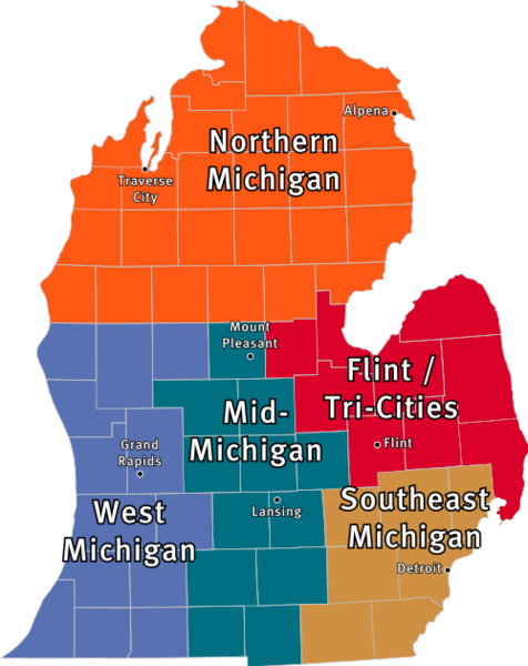
English: Map of the regions of lower Michigan |
| Source | Author |
| Author | w:User:MonkeyWrench32 |
Licensing

|
Permission is granted to copy, distribute and/or modify this document under the terms of the GNU Free Documentation License, Version 1.2 or any later version published by the Free Software Foundation; with no Invariant Sections, no Front-Cover Texts, and no Back-Cover Texts. A copy of the license is included in the section entitled GNU Free Documentation License.http://www.gnu.org/copyleft/fdl.htmlGFDLGNU Free Documentation Licensetruetrue |

|
This image could be re-created using vector graphics as an SVG file. This has several advantages; see Commons:Media for cleanup for more information. If an SVG form of this image is available, please upload it and afterwards replace this template with
{{vector version available|new image name}}.
It is recommended to name the SVG file “Lower Michigan Region Map.svg”—then the template Vector version available (or Vva) does not need the new image name parameter. |
Captions
Add a one-line explanation of what this file represents
Items portrayed in this file
depicts
image/png
File history
Click on a date/time to view the file as it appeared at that time.
| Date/Time | Thumbnail | Dimensions | User | Comment | |
|---|---|---|---|---|---|
| current | 08:04, 7 February 2011 | | 476 × 600 (141 KB) | Armbrust | Reverted to version as of 07:46, 7 February 2011 |
| 08:03, 7 February 2011 |  | 768 × 614 (136 KB) | Timeofseasons | Reverted to version as of 07:44, 7 February 2011 | |
| 07:46, 7 February 2011 |  | 476 × 600 (141 KB) | Armbrust | Reverted to version as of 07:36, 7 February 2011 | |
| 07:44, 7 February 2011 |  | 768 × 614 (136 KB) | Timeofseasons | Reverted to version as of 07:19, 7 February 2011 | |
| 07:36, 7 February 2011 |  | 476 × 600 (141 KB) | Armbrust | Reverted to version as of 07:16, 7 February 2011 | |
| 07:19, 7 February 2011 |  | 768 × 614 (136 KB) | Timeofseasons | Reverted to version as of 07:05, 7 February 2011 | |
| 07:16, 7 February 2011 |  | 476 × 600 (141 KB) | Armbrust | Reverted to version as of 07:03, 7 February 2011 it has a transparent background | |
| 07:05, 7 February 2011 |  | 768 × 614 (136 KB) | Timeofseasons | Reverted to version as of 07:04, 7 February 2011 | |
| 07:04, 7 February 2011 |  | 768 × 614 (136 KB) | Timeofseasons | Reverted to version as of 07:04, 7 February 2011 | |
| 07:04, 7 February 2011 |  | 768 × 614 (136 KB) | Timeofseasons |
File usage
The following pages on the English Wikipedia use this file (pages on other projects are not listed):
Metadata
This file contains additional information, probably added from the digital camera or scanner used to create or digitize it.
If the file has been modified from its original state, some details may not fully reflect the modified file.
| Horizontal resolution | 28.35 dpc |
|---|---|
| Vertical resolution | 28.35 dpc |
Retrieved from "https://en.wikipedia.org/wiki/File:Lower_Michigan_Region_Map.png"