File:HNL_-_FAA_airport_diagram.png
From Wikipedia, the free encyclopedia
Size of this preview: 800 × 521 pixels. Other resolutions: 320 × 208 pixels | 640 × 417 pixels | 1,024 × 667 pixels | 1,280 × 834 pixels | 1,650 × 1,075 pixels.
Original file (1,650 × 1,075 pixels, file size: 168 KB, MIME type: image/png)
| This is a file from the Wikimedia Commons. Information from its description page there is shown below. Commons is a freely licensed media file repository. You can help. |
Summary
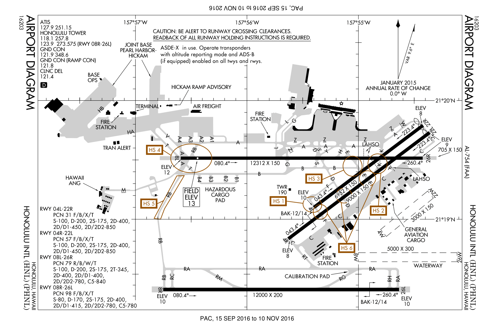
| DescriptionHNL - FAA airport diagram.png | FAA airport diagram for Honolulu International Airport (HNL) in Honolulu, Hawaii, United States. |
| Date | Effective 2005-09-29 to 2005-10-27. |
| Source |
http://www.naco.faa.gov/d-tpp/0510/00754AD.PDF Note: this URL changes every 28 days; the airport article should contain a link to the current FAA diagram. |
| Author | Produced by the National Aeronautical Charting Office (NACO), a department of the Federal Aviation Administration (FAA). |
| Permission (Reusing this file) |
Public domain. |
Licensing
| Public domainPublic domainfalsefalse |
This image or file is a work of a Federal Aviation Administration employee, taken or made as part of that person's official duties. As a work of the U.S. federal government, the image is in the public domain in the United States.
English | italiano | македонски | മലയാളം | Nederlands | русский | sicilianu | українська | 中文 | +/− |
 |
Original upload log
Originally from en:wikipedia; description page is/was here. (All user names refer to en.wikipedia)
- 2005-10-26 18:23 Zyxw 619×403×8 (43670 bytes) FAA diagram of [[Honolulu International Airport]] (HNL) http://www.naco.faa.gov/d-tpp/0510/00754AD.PDF
Original upload log
| date/time | username | resolution | size | edit summary |
|---|---|---|---|---|
| 05:44, 30 September 2007 | User:Darkwind | 619×403 | 43 KB | <span class="comment">({{Information |Description=FAA diagram of <a href="http://en.wikipedia.org/wiki/Honolulu_International_Airport" class="extiw" title="en:Honolulu_International_Airport">en:Honolulu International Airport</a> (HNL) http://www.naco.faa.gov/d-tpp/0510/00754AD.PDF <a href="http://en.wikipedia.org/wiki/commons:category:Honolulu_International_Airport" class="extiw" title="en:commons:category:Honolulu_International_Airport">en:commons:category:Honolulu International Airport</a> <a href="http://en.wikipedia.org/wiki/commons:category:Federal_Aviation_Administration" class="extiw" title="en:commons:category:Federal_Aviation_Administration">en:commons:category:Federal Aviation Administration</a> [[)</span> |
Original upload log
| Date/Time | Dimensions | User | Comment |
|---|---|---|---|
| 8 May 2008, 17:01:18 | 619 × 403 (43670 bytes) | BetacommandBot (talk · contribs) | move approved by: [[User:Siebrand]] This image was moved from [[:Image:00754AD.gif]] {{badGIF}} == Summary == {{Information | Description = FAA airport diagram for [[:en:Honolulu International Airport|Honolulu International Airport]] (HNL) in Honolulu, |
File history
Click on a date/time to view the file as it appeared at that time.
| Date/Time | Thumbnail | Dimensions | User | Comment | |
|---|---|---|---|---|---|
| current | 18:01, 29 October 2016 | | 1,650 × 1,075 (168 KB) | Will211 | Updated version (October 2016) |
| 18:37, 9 August 2015 |  | 619 × 403 (32 KB) | GifTagger | Bot: Converting file to superior PNG file. (Source: HNL - FAA airport diagram.gif). This GIF was problematic due to non-greyscale color table. |
File usage
The following pages on the English Wikipedia use this file (pages on other projects are not listed):
Global file usage
The following other wikis use this file:
- Usage on af.wikipedia.org
- Usage on de.wikipedia.org
- Usage on es.wikipedia.org
- Usage on fa.wikipedia.org
- Usage on fi.wikipedia.org
- Usage on fr.wikipedia.org
- Usage on he.wikipedia.org
- Usage on id.wikipedia.org
- Usage on pl.wikipedia.org
- Usage on simple.wikipedia.org
- Usage on sv.wikipedia.org
- Usage on th.wikipedia.org
- Usage on ur.wikipedia.org
- Usage on vi.wikipedia.org
Metadata
This file contains additional information, probably added from the digital camera or scanner used to create or digitize it.
If the file has been modified from its original state, some details may not fully reflect the modified file.
| Horizontal resolution | 37.79 dpc |
|---|---|
| Vertical resolution | 37.79 dpc |
Retrieved from "https://en.wikipedia.org/wiki/File:HNL_-_FAA_airport_diagram.png"