File:Grossdeutsches_Reich_Staatliche_Administration_1944.png
From Wikipedia, the free encyclopedia
Original file (2,606 × 2,023 pixels, file size: 270 KB, MIME type: image/png)
| This is a file from the Wikimedia Commons. Information from its description page there is shown below. Commons is a freely licensed media file repository. You can help. |
Summary
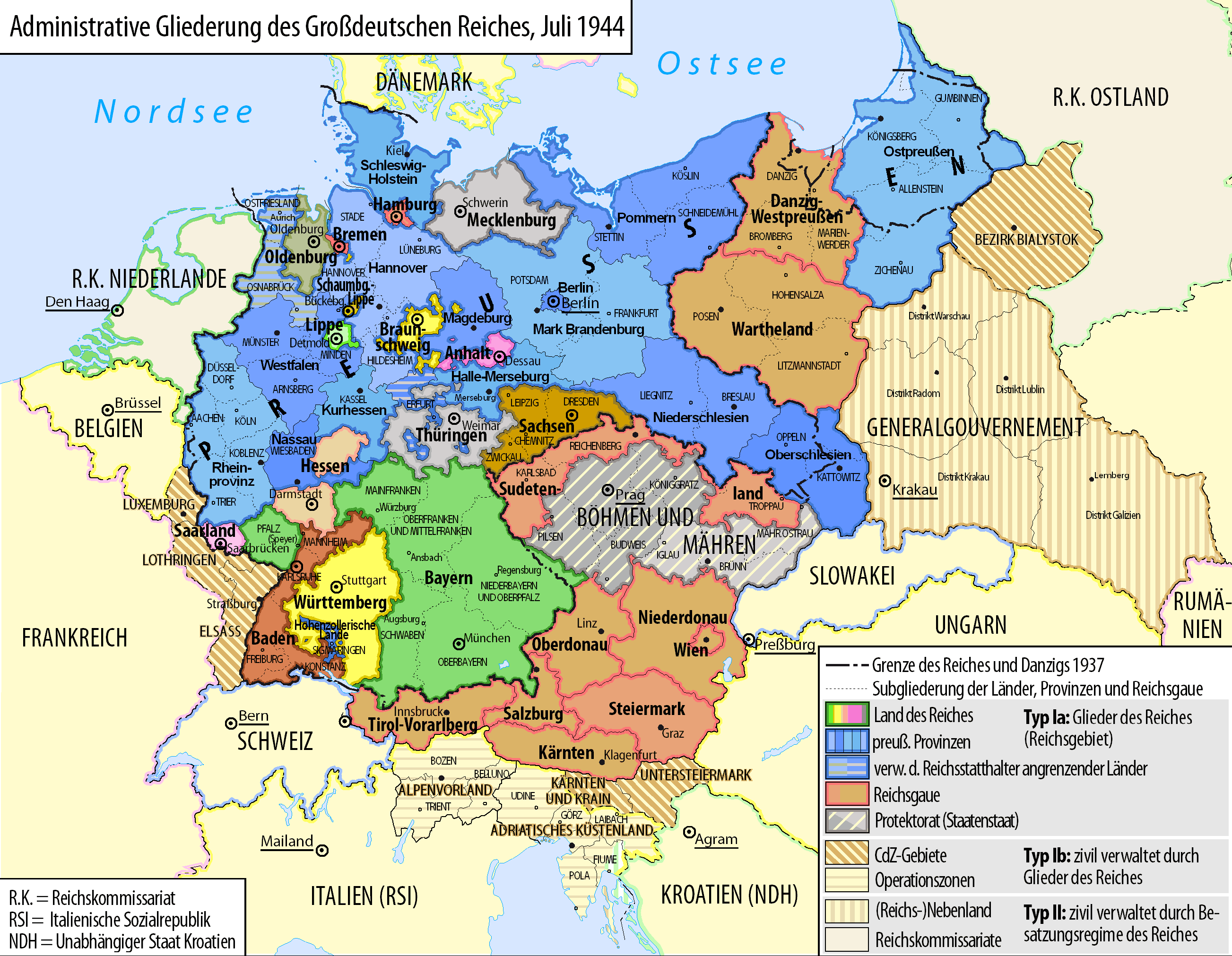
| DescriptionGrossdeutsches Reich Staatliche Administration 1944.png |
Deutsch: Karte der administrativen Gliederung des Großdeutschen Reiches in Länder, preußische Provinzen und Reichsgaue 1944.
English: Map of the administrative division of the Greater German Reich ("Großdeutsches Reich"/"Großdeutschland"/"Greater German Empire"/"Greater Germany") by federal states, Prussian provinces and Reichsgaue 1944 (in German).
Polski: Mapa Wielkiej Rzeszy Niemieckiej (1944) |
||
| Date | |||
| Source | Own work | ||
| Author | Bennet Schulte | ||
| Permission (Reusing this file) |
|
||
| Other versions |
|


Licensing
- You are free:
- to share – to copy, distribute and transmit the work
- to remix – to adapt the work
- Under the following conditions:
- attribution – You must give appropriate credit, provide a link to the license, and indicate if changes were made. You may do so in any reasonable manner, but not in any way that suggests the licensor endorses you or your use.
- share alike – If you remix, transform, or build upon the material, you must distribute your contributions under the same or compatible license as the original.

|
Permission is granted to copy, distribute and/or modify this document under the terms of the GNU Free Documentation License, Version 1.2 or any later version published by the Free Software Foundation; with no Invariant Sections, no Front-Cover Texts, and no Back-Cover Texts. A copy of the license is included in the section entitled GNU Free Documentation License.http://www.gnu.org/copyleft/fdl.htmlGFDLGNU Free Documentation Licensetruetrue |
Captions
Items portrayed in this file
depicts
some value
1 September 2010
image/png
File history
Click on a date/time to view the file as it appeared at that time.
| Date/Time | Thumbnail | Dimensions | User | Comment | |
|---|---|---|---|---|---|
| current | 13:22, 19 September 2014 | | 2,606 × 2,023 (270 KB) | Exec | - Titel und Legende |
| 14:57, 27 January 2014 |  | 5,212 × 4,044 (623 KB) | Exec | - weitere Bearbeitungsphase | |
| 16:10, 14 October 2010 |  | 2,614 × 2,028 (1.17 MB) | Exec | -weitere Bearbeitungsphase | |
| 19:48, 6 October 2010 |  | 2,615 × 2,030 (123 KB) | Exec | -Gaue eine Farbe -weitere Innenbänder für die Länder hinzugefügt -Regierungsbezirke mit grauen Trennlinien | |
| 16:09, 1 October 2010 |  | 2,615 × 2,032 (118 KB) | Exec | {{Information |Description={{en|1=Testmap}} |Source={{own}} |Author=Exec |Date= |Permission= |other_versions= }} |
File usage
Global file usage
The following other wikis use this file:
- Usage on als.wikipedia.org
- Usage on ar.wikipedia.org
- Usage on be.wikipedia.org
- Usage on ca.wikipedia.org
- Usage on de.wikipedia.org
- Geschichte Deutschlands
- Neugliederung des Bundesgebietes
- Geschichte Bayerns
- Reichsstatthalter
- Provinz Halle-Merseburg
- Provinz Magdeburg
- Provinz Kurhessen
- NS-Staat
- Verwaltungsgliederung Preußens
- Portal Diskussion:Nationalsozialismus/Archiv/2010
- Salzgitter-Gesetz
- Portal Diskussion:Nationalsozialismus/Archiv/2014
- Usage on el.wikipedia.org
- Usage on es.wikipedia.org
- Usage on ja.wikipedia.org
- Usage on kk.wikipedia.org
- Usage on ku.wikipedia.org
- Usage on lv.wikipedia.org
- Usage on nl.wikipedia.org
- Usage on no.wikipedia.org
- Usage on pt.wikipedia.org
- Usage on ru.wikipedia.org
- Usage on simple.wikipedia.org
- Usage on sl.wikipedia.org
- Usage on tr.wikipedia.org
- Usage on zh.wikipedia.org
Metadata
This file contains additional information, probably added from the digital camera or scanner used to create or digitize it.
If the file has been modified from its original state, some details may not fully reflect the modified file.
| Software used |
|---|