File:Grossdeutsches_Reich_NS_Administration_1944.png
From Wikipedia, the free encyclopedia
Original file (2,615 × 2,030 pixels, file size: 250 KB, MIME type: image/png)
| This is a file from the Wikimedia Commons. Information from its description page there is shown below. Commons is a freely licensed media file repository. You can help. |
Summary
| DescriptionGrossdeutsches Reich NS Administration 1944.png |
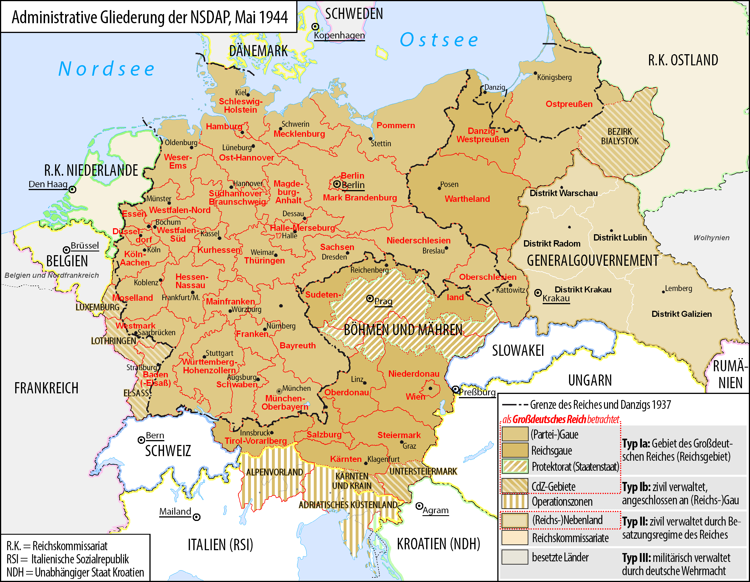
Deutsch: Karte der administrativen Gliederung des Großdeutschen Reiches durch die NSDAP 1944.
English: Map of the administrative division of the Greater German Reich ("Großdeutsches Reich"/"Großdeutschland"/"Greater German Empire"/"Greater Germany") by the NSDAP 1944 (in German).
Polski: Mapa Wielkiej Rzeszy Niemieckiej (1944) |
||
| Date | |||
| Source | Own work | ||
| Author | Bennet Schulte | ||
| Permission (Reusing this file) |
|
||
| Other versions |
|


Licensing
- You are free:
- to share – to copy, distribute and transmit the work
- to remix – to adapt the work
- Under the following conditions:
- attribution – You must give appropriate credit, provide a link to the license, and indicate if changes were made. You may do so in any reasonable manner, but not in any way that suggests the licensor endorses you or your use.
- share alike – If you remix, transform, or build upon the material, you must distribute your contributions under the same or compatible license as the original.

|
Permission is granted to copy, distribute and/or modify this document under the terms of the GNU Free Documentation License, Version 1.2 or any later version published by the Free Software Foundation; with no Invariant Sections, no Front-Cover Texts, and no Back-Cover Texts. A copy of the license is included in the section entitled GNU Free Documentation License.http://www.gnu.org/copyleft/fdl.htmlGFDLGNU Free Documentation Licensetruetrue |
Captions
Items portrayed in this file
depicts
some value
1 September 2010
image/png
File history
Click on a date/time to view the file as it appeared at that time.
| Date/Time | Thumbnail | Dimensions | User | Comment | |
|---|---|---|---|---|---|
| current | 05:23, 3 June 2017 | | 2,615 × 2,030 (250 KB) | Exec | auf vielfachen Wunsch wurden die zum Zeitpunkt der Darstellung existierenden militärisch verwalteten Gebiete "Wolhynien" (Rest von RK Ukraine) sowie "Belgien und Nordfrankreich" beschriftet und abgegrenzt wenn abweichend von Staatsgrenzen |
| 00:26, 4 February 2016 |  | 2,615 × 2,030 (344 KB) | Exec | Reverted to version as of 10:37, 11 September 2015 (UTC): thematic content don't include military administative units, see https://commons.wikimedia.org/wiki/File_talk:Greater_German_Reich_NS_Administration_1944.png#Problems_with_the_map | |
| 15:04, 6 December 2015 |  | 2,607 × 2,022 (579 KB) | Braganza | Reverted to version as of 22:32, 7 July 2014 (UTC) | |
| 10:37, 11 September 2015 |  | 2,615 × 2,030 (344 KB) | RokerHRO | optipng -i0 -zc1-9 -zm1-9 -zs0-3 -f0-5 -i0 → 35.13% decrease | |
| 09:32, 27 June 2015 |  | 2,615 × 2,030 (530 KB) | Exec | - clearified phrase for dotted line (statt "dargestellt als", "als betrachtet" | |
| 09:23, 27 June 2015 |  | 2,616 × 2,029 (530 KB) | Exec | - added subdevision of the Operationszonen - fixed explanation of red dotted line (visualisation in cartographic materials as Großdeutsches Reich) and exclude Operationszonen | |
| 00:18, 3 April 2015 |  | 2,607 × 2,022 (231 KB) | Exec | Reverted to version as of 21:17, 17 July 2014 because no fixes are identified but some black objects are switched to grey with out logic and benefit.undaries to grey | |
| 07:08, 29 March 2015 |  | 2,607 × 2,022 (345 KB) | DIREKTOR | Small fix. | |
| 21:17, 17 July 2014 |  | 2,607 × 2,022 (231 KB) | Execger | Boundaries of millitary administration is not part of the thematic content. | |
| 22:32, 7 July 2014 |  | 2,607 × 2,022 (579 KB) | Victor falk~commonswiki | belgien und nordfrankreich |
File usage
Global file usage
The following other wikis use this file:
- Usage on cs.wikipedia.org
- Usage on da.wikipedia.org
- Usage on de.wikipedia.org
- Gau
- Geschichte Österreichs
- Generalgouvernement
- Beneš-Dekrete
- Reichsstatthalter
- Reichsgau
- Danzig-Westpreußen
- Deutsche Frage
- Geschichte der Steiermark
- Kriegsschauplatz Mittelmeerraum
- NS-Staat
- Diskussion:Liste der größten deutschen Städte
- Liste der Wappen in Deutschland
- Geschichte Niederösterreichs
- Deutschland
- Operationszone Adriatisches Küstenland
- Diskussion:Deutschland/Archiv/2
- Geschichte Oberösterreichs
- Ostmarkgesetz
- Portal Diskussion:Nationalsozialismus/Archiv/2010
- Liste der Postleitregionen in Deutschland
- Wikipedia:Kartenwerkstatt/Archiv/Zurückgewiesene und zurückgestellte Aufträge 2012
- Portal Diskussion:Nationalsozialismus/Archiv/2014
- Diskussion:Uschi Nerke
- Wikipedia:Redaktion Geschichte/Archiv/2023/Feb
- Usage on frr.wikipedia.org
- Usage on fr.wikipedia.org
- Usage on fr.wiktionary.org
- Usage on gl.wikipedia.org
- Usage on hak.wikipedia.org
- Usage on he.wikipedia.org
- Usage on it.wikipedia.org
- Usage on ja.wikipedia.org
- Usage on lb.wikipedia.org
View more global usage of this file.
Metadata
This file contains additional information, probably added from the digital camera or scanner used to create or digitize it.
If the file has been modified from its original state, some details may not fully reflect the modified file.
| Software used |
|---|