File:Green_River_Overlook_Ekker_Butte.jpg
From Wikipedia, the free encyclopedia
Size of this preview: 800 × 497 pixels. Other resolutions: 320 × 199 pixels | 640 × 398 pixels | 1,024 × 636 pixels | 1,280 × 795 pixels | 3,059 × 1,900 pixels.
Original file (3,059 × 1,900 pixels, file size: 1.89 MB, MIME type: image/jpeg)
| This is a file from the Wikimedia Commons. Information from its description page there is shown below. Commons is a freely licensed media file repository. You can help. |
Summary
| DescriptionGreen River Overlook Ekker Butte.jpg |
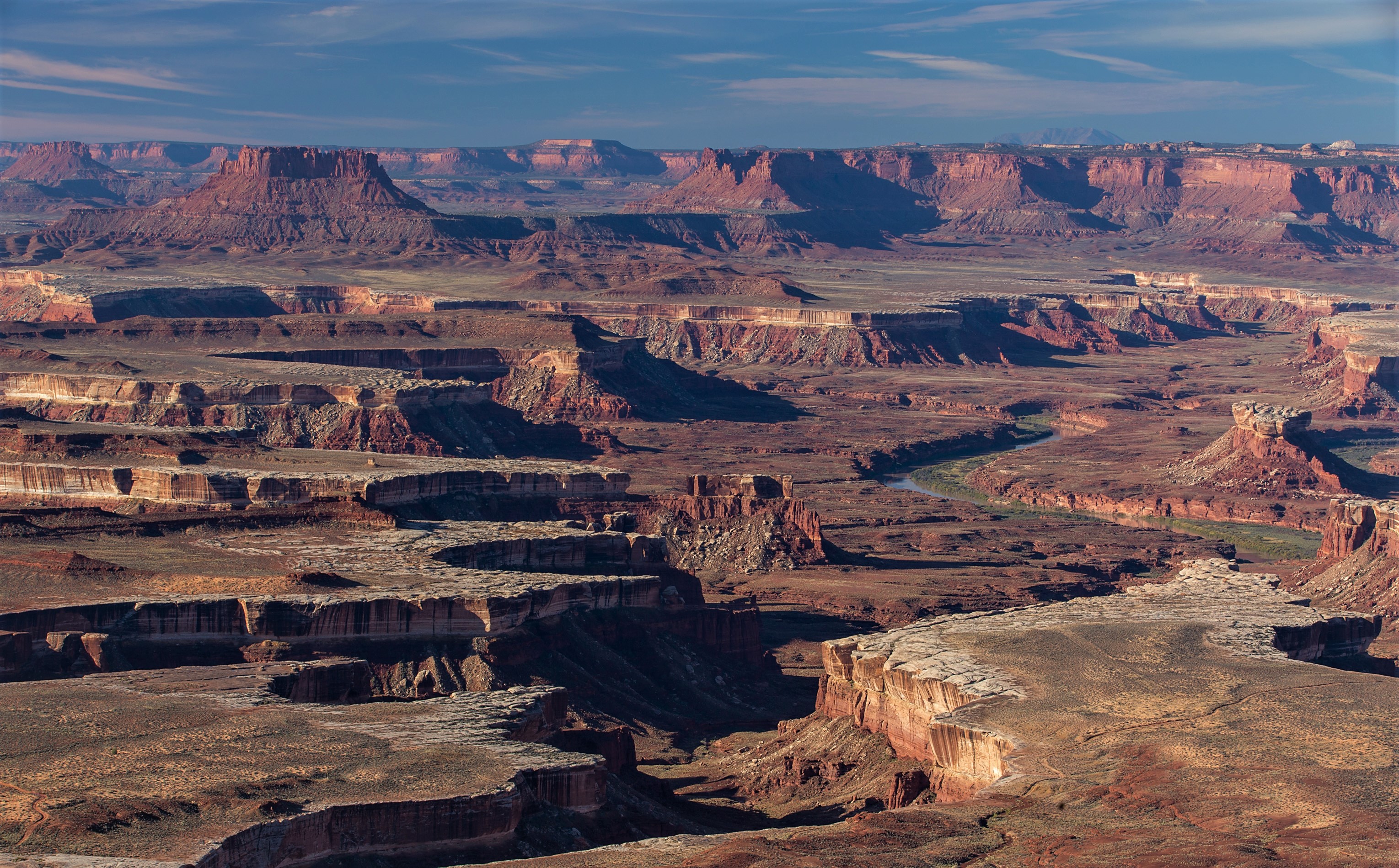
English: Green River Overlook, one of the few spots at Island in the Sky where you can actually see the river, the canyons are that deep! Ekker Butte upper left, Turks Head (right). |
| Date | Taken on 24 October 2015, 09:37:36 |
| Source | https://www.flickr.com/photos/au_ears/25373576072/ |
| Author | au_ears |
| Camera location | 38° 22′ 42.04″ N, 109° 53′ 18.63″ W | View this and other nearby images on: OpenStreetMap |
|---|
Licensing
This file is licensed under the Creative Commons Attribution-Share Alike 2.0 Generic license.
- You are free:
- to share – to copy, distribute and transmit the work
- to remix – to adapt the work
- Under the following conditions:
- attribution – You must give appropriate credit, provide a link to the license, and indicate if changes were made. You may do so in any reasonable manner, but not in any way that suggests the licensor endorses you or your use.
- share alike – If you remix, transform, or build upon the material, you must distribute your contributions under the same or compatible license as the original.
| This image was originally posted to Flickr by au_ears at https://flickr.com/photos/94900399@N07/25373576072. It was reviewed on 3 November 2020 by FlickreviewR 2 and was confirmed to be licensed under the terms of the cc-by-sa-2.0. |
3 November 2020
| Annotations InfoField | This image is annotated: View the annotations at Commons |
501
287
336
187
3059
1900
Ekker Butte
2650
845
252
226
3059
1900
Turks Head
2612
1242
84
69
3059
1900
White Rim Sandstone
Captions
Add a one-line explanation of what this file represents
Items portrayed in this file
depicts
some value
24 October 2015
38°22'42.042"N, 109°53'18.629"W
0.04 second
16
88 millimetre
100
image/jpeg
File history
Click on a date/time to view the file as it appeared at that time.
| Date/Time | Thumbnail | Dimensions | User | Comment | |
|---|---|---|---|---|---|
| current | 00:29, 3 November 2020 | | 3,059 × 1,900 (1.89 MB) | Ron Clausen | crop, exposure |
| 00:27, 3 November 2020 |  | 3,072 × 2,048 (2.37 MB) | Ron Clausen | Uploaded a work by au_ears from https://www.flickr.com/photos/au_ears/25373576072/ with UploadWizard |
File usage
The following pages on the English Wikipedia use this file (pages on other projects are not listed):
Global file usage
The following other wikis use this file:
- Usage on ban.wikipedia.org
- Usage on de.wikipedia.org
- Usage on et.wikipedia.org
- Usage on ko.wikipedia.org
Metadata
This file contains additional information, probably added from the digital camera or scanner used to create or digitize it.
If the file has been modified from its original state, some details may not fully reflect the modified file.
| Image title |
|
|---|---|
| Camera manufacturer | Canon |
| Camera model | Canon EOS 6D |
| Author | Chris Larson |
| Copyright holder |
|
| Exposure time | 1/25 sec (0.04) |
| F-number | f/16 |
| ISO speed rating | 100 |
| Date and time of data generation | 09:37, 24 October 2015 |
| Lens focal length | 88 mm |
| Latitude | 38° 22′ 42.04″ N |
| Longitude | 109° 53′ 18.63″ W |
| Altitude | 1,836.1 meters above sea level |
| Label | Red |
| Online copyright statement | http://creativecommons.org/licenses/by-sa/4.0/ |
| Short title |
|
| Usage terms |
|
| Orientation | Normal |
| Horizontal resolution | 240 dpi |
| Vertical resolution | 240 dpi |
| Software used | Windows Photo Editor 10.0.10011.16384 |
| File change date and time | 16:23, 2 November 2020 |
| Exposure Program | Manual |
| Exif version | 2.3 |
| Date and time of digitizing | 09:37, 24 October 2015 |
| Shutter speed | 4.643856 |
| APEX aperture | 8 |
| Exposure bias | 0 |
| Maximum land aperture | 3 APEX (f/2.83) |
| Metering mode | Pattern |
| Flash | Flash did not fire, compulsory flash suppression |
| DateTimeOriginal subseconds | 89 |
| DateTimeDigitized subseconds | 89 |
| Color space | sRGB |
| Focal plane X resolution | 1,520 |
| Focal plane Y resolution | 1,520 |
| Focal plane resolution unit | 3 |
| Custom image processing | Normal process |
| Exposure mode | Manual exposure |
| White balance | Auto white balance |
| Scene capture type | Standard |
| GPS time (atomic clock) | 15:37:34.999 |
| Satellites used for measurement | 8 |
| Receiver status | Measurement in progress |
| Measurement mode | 3-dimensional measurement |
| Measurement precision | Poor (4.6) |
| Geodetic survey data used | WGS-84 |
| GPS date | 24 October 2015 |
| GPS tag version | 2.3.0.0 |
| Serial number of camera | 172020000532 |
| Lens used | EF70-200mm f/2.8L IS II USM |
| Rating (out of 5) | 3 |
| Date metadata was last modified | 17:11, 3 January 2017 |
| Unique ID of original document | 609A203E721CDF940ACCD523C73D3CC6 |
| Copyright status | Copyrighted |
| Keywords |
|
| Contact information | clarson@musson.com
https://www.flickr.com/photos/au_ears/
|
| IIM version | 4 |