File:Connecticut_River_Map.gif
From Wikipedia, the free encyclopedia
Size of this preview: 448 × 600 pixels. Other resolutions: 179 × 240 pixels | 578 × 774 pixels.
Original file (578 × 774 pixels, file size: 58 KB, MIME type: image/png)
| This is a file from the Wikimedia Commons. Information from its description page there is shown below. Commons is a freely licensed media file repository. You can help. |
Summary
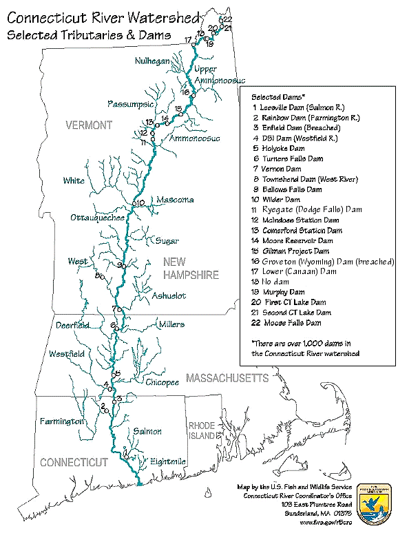
| DescriptionConnecticut River Map.png | Map of the Connecticut River, New England, USA. This map was prepared by the United States Fish and Wildlife Service, and as a product of the United States Government is in the public domain and not subject to copyright restrictions. | ||||
| Source | Originally from en.wikipedia; description page is/was here. Original uploader was Daderot at English Wikipedia | ||||
| Author | USGov | ||||
| Permission (Reusing this file) |
|


|
This transport map image could be re-created using vector graphics as an SVG file. This has several advantages; see Commons:Media for cleanup for more information. If an SVG form of this image is available, please upload it and afterwards replace this template with
{{vector version available|new image name}}.
It is recommended to name the SVG file “Connecticut River Map.svg”—then the template Vector version available (or Vva) does not need the new image name parameter. |
Original upload log
| Date/Time | Dimensions | User | Comment |
|---|---|---|---|
| 6 January 2008, 16:02:00 | 580 × 778 (61343 bytes) | Gridge (talk · contribs) | {{Information |Description=Map of the Connecticut River, New England, USA. This map was prepared by the United States Fish and Wildlife Service, and as a product of the United States Government is in the public domain and not subject to copyright restrict |
Captions
Add a one-line explanation of what this file represents
Items portrayed in this file
depicts
image/png
c04950d2689d5fe54099bed9212b219066274133
59,401 byte
774 pixel
578 pixel
File history
Click on a date/time to view the file as it appeared at that time.
| Date/Time | Thumbnail | Dimensions | User | Comment | |
|---|---|---|---|---|---|
| current | 08:26, 10 March 2024 | | 578 × 774 (58 KB) | Lojwe | Cropped < 1 % horizontally, 1 % vertically using CropTool with precise mode. |
| 04:45, 25 November 2014 |  | 580 × 778 (74 KB) | GifTagger | Bot: Converting file to superior PNG file. (Source: Connecticut_River_Map.gif). This GIF was problematic due to non-greyscale color table. |
File usage
The following pages on the English Wikipedia use this file (pages on other projects are not listed):
Global file usage
The following other wikis use this file:
- Usage on bg.wikipedia.org
- Usage on cs.wikipedia.org
- Usage on da.wikipedia.org
- Usage on de.wikipedia.org
- Usage on es.wikipedia.org
- Usage on fi.wikipedia.org
- Usage on fr.wikipedia.org
- Usage on fy.wikipedia.org
- Usage on he.wikipedia.org
- Usage on incubator.wikimedia.org
- Usage on it.wikipedia.org
- Usage on ja.wikipedia.org
- Usage on nl.wikipedia.org
- Usage on pt.wikipedia.org
- Usage on ru.wikipedia.org
- Usage on simple.wikipedia.org
- Usage on sv.wikipedia.org
- Usage on sw.wikipedia.org
- Usage on ta.wikipedia.org
- Usage on th.wikipedia.org
- Usage on www.wikidata.org
- Usage on zh.wikipedia.org
Metadata
This file contains additional information, probably added from the digital camera or scanner used to create or digitize it.
If the file has been modified from its original state, some details may not fully reflect the modified file.
| File change date and time | 08:26, 10 March 2024 |
|---|
Retrieved from "https://en.wikipedia.org/wiki/File:Connecticut_River_Map.png"