File:Colorado_Plateaus_map.png
From Wikipedia, the free encyclopedia
No higher resolution available.
Colorado_Plateaus_map.png (324 × 353 pixels, file size: 18 KB, MIME type: image/png)
| This is a file from the Wikimedia Commons. Information from its description page there is shown below. Commons is a freely licensed media file repository. You can help. |

|
This map image could be re-created using vector graphics as an SVG file. This has several advantages; see Commons:Media for cleanup for more information. If an SVG form of this image is available, please upload it and afterwards replace this template with
{{vector version available|new image name}}.
It is recommended to name the SVG file “Colorado Plateaus map.svg”—then the template Vector version available (or Vva) does not need the new image name parameter. |
Summary
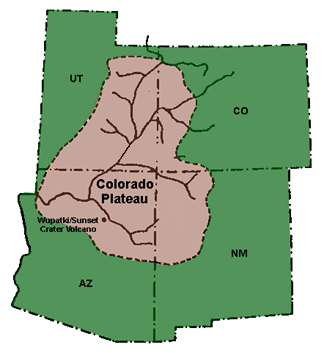
- The geographic, geologic, cultural, and biogeographic region.
- The Colorado River and Colorado River Basin originates in the Colorado Plateau.
- Source:
- U.S. NPS image @ NPS-geology: Colorado Plateau archive copy at the Wayback Machine
Licensing
| Public domainPublic domainfalsefalse |
| This image or media file contains material based on a work of a National Park Service employee, created as part of that person's official duties. As a work of the U.S. federal government, such work is in the public domain in the United States. See the NPS website and NPS copyright policy for more information. |
Captions
Map of the Colorado Plateau
Items portrayed in this file
depicts
image/png
0f554061011c873843906ede9d157e01411b8b18
18,108 byte
353 pixel
324 pixel
File history
Click on a date/time to view the file as it appeared at that time.
| Date/Time | Thumbnail | Dimensions | User | Comment | |
|---|---|---|---|---|---|
| current | 10:50, 17 May 2010 | | 324 × 353 (18 KB) | Mario1952 | {{Information |Description={{en|1=added missing section}} |Source=NPS |Author=NPS |Date= |Permission= |other_versions= }} |
| 16:08, 23 February 2005 |  | 324 × 353 (16 KB) | Complex01 |
File usage
The following pages on the English Wikipedia use this file (pages on other projects are not listed):
Global file usage
The following other wikis use this file:
- Usage on bg.wikipedia.org
- Usage on cs.wikipedia.org
- Usage on de.wikipedia.org
- Usage on eo.wikipedia.org
- Usage on es.wikipedia.org
- Usage on et.wikipedia.org
- Usage on eu.wikipedia.org
- Usage on fa.wikipedia.org
- Usage on fi.wikipedia.org
- Usage on fr.wikipedia.org
- Usage on he.wikipedia.org
- Usage on id.wikipedia.org
- Usage on is.wikipedia.org
- Usage on it.wikipedia.org
- Usage on ja.wikipedia.org
- Usage on kab.wikipedia.org
- Usage on kn.wikipedia.org
- Usage on ko.wikipedia.org
- Usage on lb.wikipedia.org
- Usage on lt.wikipedia.org
- Usage on nl.wikipedia.org
- Usage on pl.wikipedia.org
- Usage on pt.wikipedia.org
- Usage on trv.wikipedia.org
- Usage on tr.wikipedia.org
- Usage on uk.wikipedia.org
- Usage on uz.wikipedia.org
- Usage on www.wikidata.org
- Usage on zh.wikipedia.org
Retrieved from "https://en.wikipedia.org/wiki/File:Colorado_Plateaus_map.png"