Lêer:Parthia_001ad.jpg
From Wikipedia, the free encyclopedia
Oorspronklike lêer (793 × 652 piksels, lêergrootte: 741 KG, MIME-tipe: image/jpeg)
Hierdie lêer kom vanaf Wikimedia Commons en kan ook in ander projekte gebruik word. Die beskrywing op die lêer se inligtingsblad word hieronder weergegee.

|
This historical map image could be re-created using vector graphics as an SVG file. This has several advantages; see Commons:Media for cleanup for more information. If an SVG form of this image is available, please upload it and afterwards replace this template with
{{vector version available|new image name}}.
It is recommended to name the SVG file “Parthia 001ad.svg”—then the template Vector version available (or Vva) does not need the new image name parameter. |
 | This historical map image was uploaded in the JPEG format even though it consists of non-photographic data. This information could be stored more efficiently or accurately in the PNG or SVG format. If possible, please upload a PNG or SVG version of this image without compression artifacts, derived from a non-JPEG source (or with existing artifacts removed). After doing so, please tag the JPEG version with {{Superseded|NewImage.ext}} and remove this tag. This tag should not be applied to photographs or scans. If this image is a diagram or other image suitable for vectorisation, please tag this image with {{Convert to SVG}} instead of {{BadJPEG}}. If not suitable for vectorisation, use {{Convert to PNG}}. For more information, see {{BadJPEG}}. |  |
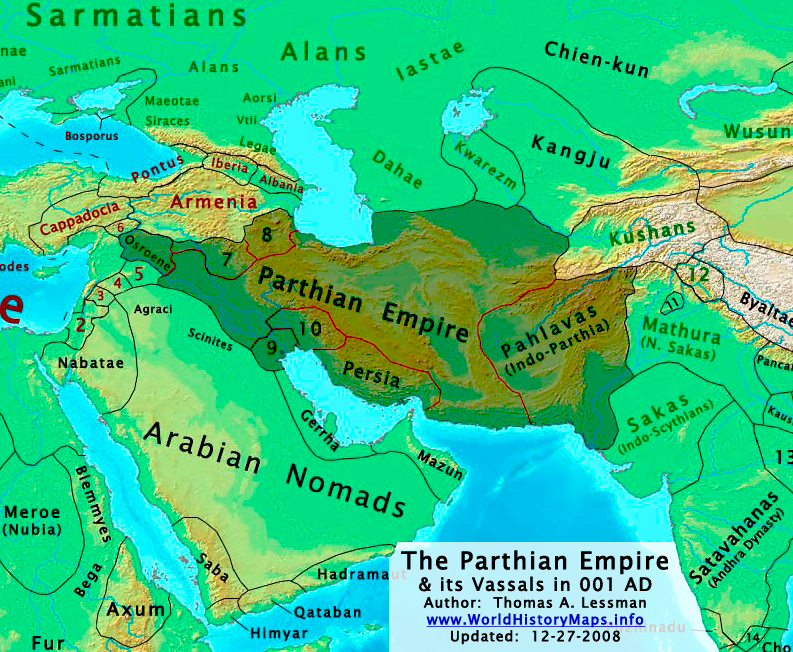
| BeskrywingParthia 001ad.jpg | The Parthian Empire in 001 AD. |
| Datum | |
| Bron | Eie werk; derived from (1) John Nelson. Interactive Historical Atlas of the World. Map of "Countries of the World 1/1/001 CE" and (2) Encyclopaedia Iranica, their article about the Parthians. |
| Outeur | Thomas Lessman (Contact!) |
| Toestemming (Hergebruik van die lêer) |
This file is licensed under the Creative Commons Attribution 3.0 Unported license.
|
| Ander weergawes | see below, العربيَّة |
Map Summary

Original Source URL: http://www.worldhistorymaps.info/images/East-Hem_001ad.jpg
This map is a zoomed-in version of Thomas Lessman's map of the
East-Hem_001ad.jpg (also available at www.WorldHistoryMaps.info).
The highlighted areas represent the Parthian Empire and its vassal kingdoms in the year 1 AD.
Map Source References
Remember, sources often conflict with each other. This map is only as accurate as the information that is available to me. To report any errors or to help further this work, please click here, or email Thomas Lessman at talessman@yis.us
References for information contained in this map:
Other Maps by Thomas Lessman
| Maps of the eastern hemisphere showing history
Bold dates are available on Wikimedia or Wikipedia. | ||
| Primeval | ||
| Ancient
|
·| 600 BC | 550 BC | 527 BC | 500 BC |
400 BC | ·| 1 AD | 50 AD | 100 AD | 200 AD | 300 AD | | |
| Medieval |
·| 500 AD | 565 AD | 600 AD | 700 AD | | |
| Modern |
·| 1500 AD | · * For historical maps of the whole world, | |
| history links talk edit view | ||
Other Info
Captions
Items portrayed in this file
uitbeelding
some value
30 Januarie 2008
source of file Engels
Lêergeskiedenis
Klik op die datum/tyd om te sien hoe die lêer destyds gelyk het.
| Datum/Tyd | Duimnael | Dimensies | Gebruiker | Opmerking | |
|---|---|---|---|---|---|
| huidig | 02:09, 29 Desember 2008 | | 793 × 652 (741 KG) | Talessman | Category:Maps of the history of Iran |
| 21:37, 16 Mei 2008 |  | 1 025 × 677 (771 KG) | Talessman | Improved border appearance, corrected eastern borders of Parthia, other corrections explained on the [http://commons.wikimedia.org/wiki/Image:East-Hem_001ad.jpg East-Hem_001ad.jpg] description page. | |
| 22:51, 9 Mei 2008 |  | 1 022 × 854 (286 KG) | Talessman | {{Information |Description='''<big>The [http://en.wikipedia.org/wiki/Parthian_Empire Parthian Empire] in 001 AD.'''</big> |Source=Self-made |Author=Thomas Lessman (Contact!) |Permission={{self|cc-by-sa-3.0}} }} |
Lêergebruik
Die volgende 2 bladsye gebruik dié lêer:
Globale lêergebruik
Die volgende ander wiki's gebruik hierdie lêer:
- Gebruik in an.wikipedia.org
- Gebruik in ar.wikipedia.org
- Gebruik in av.wikipedia.org
- Gebruik in azb.wikipedia.org
- Gebruik in az.wikipedia.org
- Gebruik in ba.wikipedia.org
- Gebruik in be.wikipedia.org
- Gebruik in bg.wikipedia.org
- Gebruik in ca.wikipedia.org
- Gebruik in ceb.wikipedia.org
- Gebruik in ckb.wikipedia.org
- Gebruik in cs.wikipedia.org
- Gebruik in da.wikipedia.org
- Gebruik in de.wikipedia.org
- Gebruik in el.wikipedia.org
- Gebruik in en.wikipedia.org
- Mark Antony
- Amol
- Roman–Persian Wars
- User:Talessman/Maps
- Roman–Parthian Wars
- User:Dhatfield/Image to Vector Tutorial
- User:Xashaiar/Parthia
- User talk:Rs4815
- User:HistoryofIran/Asfar ibn Shiruya
- User:Joelton Ivson/Gather lists/24978 – Os Romanos
- Chronicle of Arbela
- User:Falcaorib/Ancient Empires (01 AD-150 AD)
- Gebruik in es.wikipedia.org
- Gebruik in fa.wikipedia.org
- Gebruik in fr.wikipedia.org
Wys meer globale gebruik van die lêer.
Metadata
Die lêer bevat aanvullende inligting wat moontlik deur 'n digitale kamera of skandeerder bygevoeg is.
As die lêer verander is, sal sekere inligting dalk nie meer ooreenkom met dié van die gewysigde lêer nie.
| _error | 0 |
|---|